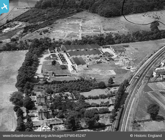
EPW045247 ENGLAND (1934). The Oldfield Works, Hampton, 1934
© Copyright OpenStreetMap contributors and licensed by the OpenStreetMap Foundation. 2026. Cartography is licensed as CC BY-SA.
Nearby Images (24)
Details
| Title | [EPW045247] The Oldfield Works, Hampton, 1934 |
| Reference | EPW045247 |
| Date | July-1934 |
| Link | |
| Place name | HAMPTON |
| Parish | |
| District | |
| Country | ENGLAND |
| Easting / Northing | 512737, 169792 |
| Longitude / Latitude | -0.3786409092665, 51.41542893137 |
| National Grid Reference | TQ127698 |
Pins
Be the first to add a comment to this image!


![[EPW045247] The Oldfield Works, Hampton, 1934](http://britainfromabove.org.uk/sites/all/libraries/aerofilms-images/public/100x100/EPW/045/EPW045247.jpg)
![[EPW045251] The Oldfield Works, Hampton, 1934. This image has been produced from a damaged negative.](http://britainfromabove.org.uk/sites/all/libraries/aerofilms-images/public/100x100/EPW/045/EPW045251.jpg)
![[EPW045641] The Oldfield Works, Hampton, 1934. This image has been produced from a damaged negative.](http://britainfromabove.org.uk/sites/all/libraries/aerofilms-images/public/100x100/EPW/045/EPW045641.jpg)
![[EPW045640] The Oldfield Works, Hampton, 1934](http://britainfromabove.org.uk/sites/all/libraries/aerofilms-images/public/100x100/EPW/045/EPW045640.jpg)
![[EPW045248] The Oldfield Works, Hampton, 1934](http://britainfromabove.org.uk/sites/all/libraries/aerofilms-images/public/100x100/EPW/045/EPW045248.jpg)
![[EPW037784] The Oldfield Works, Hampton, 1932](http://britainfromabove.org.uk/sites/all/libraries/aerofilms-images/public/100x100/EPW/037/EPW037784.jpg)
![[EPW045638] The Oldfield Works, Hampton, 1934. This image has been produced from a damaged negative.](http://britainfromabove.org.uk/sites/all/libraries/aerofilms-images/public/100x100/EPW/045/EPW045638.jpg)
![[EPW041098] Hall and Hall Oldfield Works (Hydraulic Packing), Hampton, 1933](http://britainfromabove.org.uk/sites/all/libraries/aerofilms-images/public/100x100/EPW/041/EPW041098.jpg)
![[EPW045249] The Oldfield Works, Hampton, 1934](http://britainfromabove.org.uk/sites/all/libraries/aerofilms-images/public/100x100/EPW/045/EPW045249.jpg)
![[EPW053644] The Oldfield Works, Hampton, 1937](http://britainfromabove.org.uk/sites/all/libraries/aerofilms-images/public/100x100/EPW/053/EPW053644.jpg)
![[EPW053647] The Oldfield Works, Hampton, 1937](http://britainfromabove.org.uk/sites/all/libraries/aerofilms-images/public/100x100/EPW/053/EPW053647.jpg)
![[EPW037782] The Oldfield Works, Hampton, 1932](http://britainfromabove.org.uk/sites/all/libraries/aerofilms-images/public/100x100/EPW/037/EPW037782.jpg)
![[EPW053645] The Oldfield Works, Hampton, 1937](http://britainfromabove.org.uk/sites/all/libraries/aerofilms-images/public/100x100/EPW/053/EPW053645.jpg)
![[EPW037783] The Oldfield Works, Hampton, 1932](http://britainfromabove.org.uk/sites/all/libraries/aerofilms-images/public/100x100/EPW/037/EPW037783.jpg)
![[EPW045250] The Oldfield Works, Hampton, 1934](http://britainfromabove.org.uk/sites/all/libraries/aerofilms-images/public/100x100/EPW/045/EPW045250.jpg)
![[EPW053648] The Oldfield Works, Hampton, 1937](http://britainfromabove.org.uk/sites/all/libraries/aerofilms-images/public/100x100/EPW/053/EPW053648.jpg)
![[EPW053643] The Oldfield Works, Hampton, 1937](http://britainfromabove.org.uk/sites/all/libraries/aerofilms-images/public/100x100/EPW/053/EPW053643.jpg)
![[EPW053646] The Oldfield Works, Hampton, 1937](http://britainfromabove.org.uk/sites/all/libraries/aerofilms-images/public/100x100/EPW/053/EPW053646.jpg)
![[EPW041097] Hall and Hall Oldfield Works (Hydraulic Packing), Hampton, 1933](http://britainfromabove.org.uk/sites/all/libraries/aerofilms-images/public/100x100/EPW/041/EPW041097.jpg)
![[EPW022860] The Oldfield Works, Hampton, 1928](http://britainfromabove.org.uk/sites/all/libraries/aerofilms-images/public/100x100/EPW/022/EPW022860.jpg)
![[EPW045639] The Oldfield Works, Hampton, 1934. This image has been produced from a damaged negative.](http://britainfromabove.org.uk/sites/all/libraries/aerofilms-images/public/100x100/EPW/045/EPW045639.jpg)
![[EPW041096] Hall and Hall Oldfield Works (Hydraulic Packing) and Metropolitan Water Board Water Works, Hampton, 1933](http://britainfromabove.org.uk/sites/all/libraries/aerofilms-images/public/100x100/EPW/041/EPW041096.jpg)
![[EPW041099] Hall and Hall Oldfield Works (Hydraulic Packing) and Metropolitan Water Board Water Works, Hampton, 1933](http://britainfromabove.org.uk/sites/all/libraries/aerofilms-images/public/100x100/EPW/041/EPW041099.jpg)
![[EPW041095] Hall and Hall Oldfield Works (Hydraulic Packing) and Metropolitan Water Board Water Works, Hampton, 1933](http://britainfromabove.org.uk/sites/all/libraries/aerofilms-images/public/100x100/EPW/041/EPW041095.jpg)