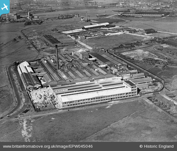
EPW045046 ENGLAND (1934). The Turners Asbestos Cement Works and surrounding industrial works, Trafford Park, 1934
© Copyright OpenStreetMap contributors and licensed by the OpenStreetMap Foundation. 2026. Cartography is licensed as CC BY-SA.
Nearby Images (38)
Details
| Title | [EPW045046] The Turners Asbestos Cement Works and surrounding industrial works, Trafford Park, 1934 |
| Reference | EPW045046 |
| Date | June-1934 |
| Link | |
| Place name | TRAFFORD PARK |
| Parish | |
| District | |
| Country | ENGLAND |
| Easting / Northing | 377789, 397285 |
| Longitude / Latitude | -2.3346524052717, 53.471576959431 |
| National Grid Reference | SJ778973 |
Pins
Be the first to add a comment to this image!


![[EPW045046] The Turners Asbestos Cement Works and surrounding industrial works, Trafford Park, 1934](http://britainfromabove.org.uk/sites/all/libraries/aerofilms-images/public/100x100/EPW/045/EPW045046.jpg)
![[EPW060417] Turners Asbestos Cement Co Works, Trafford Park, 1939](http://britainfromabove.org.uk/sites/all/libraries/aerofilms-images/public/100x100/EPW/060/EPW060417.jpg)
![[EPW045047] The Turners Asbestos Cement Works and surrounding industrial works, Trafford Park, 1934](http://britainfromabove.org.uk/sites/all/libraries/aerofilms-images/public/100x100/EPW/045/EPW045047.jpg)
![[EPW045044] The Turners Asbestos Cement Works, Trafford Park, 1934](http://britainfromabove.org.uk/sites/all/libraries/aerofilms-images/public/100x100/EPW/045/EPW045044.jpg)
![[EPW045045] The Turners Asbestos Cement Works and surrounding industrial works, Trafford Park, 1934](http://britainfromabove.org.uk/sites/all/libraries/aerofilms-images/public/100x100/EPW/045/EPW045045.jpg)
![[EPW045041] The Turners Asbestos Cement Works, Trafford Park, 1934](http://britainfromabove.org.uk/sites/all/libraries/aerofilms-images/public/100x100/EPW/045/EPW045041.jpg)
![[EPW060500] Turners Asbestos Cement Co Ltd, Trafford Park, 1939](http://britainfromabove.org.uk/sites/all/libraries/aerofilms-images/public/100x100/EPW/060/EPW060500.jpg)
![[EPW060499] Turners Asbestos Cement Co Ltd, Trafford Park, 1939](http://britainfromabove.org.uk/sites/all/libraries/aerofilms-images/public/100x100/EPW/060/EPW060499.jpg)
![[EPW016585] The Turner Brothers Asbestos Co. Ltd., Trafford Park, 1926](http://britainfromabove.org.uk/sites/all/libraries/aerofilms-images/public/100x100/EPW/016/EPW016585.jpg)
![[EPW045040] The Turners Asbestos Cement Works and an unidentified Steel Works, Trafford Park, 1934](http://britainfromabove.org.uk/sites/all/libraries/aerofilms-images/public/100x100/EPW/045/EPW045040.jpg)
![[EPW016583] The Turner Brothers Asbestos Co. Ltd., Trafford Park, 1926](http://britainfromabove.org.uk/sites/all/libraries/aerofilms-images/public/100x100/EPW/016/EPW016583.jpg)
![[EPW045042] The Turners Asbestos Cement Works, Trafford Park, 1934](http://britainfromabove.org.uk/sites/all/libraries/aerofilms-images/public/100x100/EPW/045/EPW045042.jpg)
![[EPW016582] The Turner Brothers Asbestos Co. Ltd., Trafford Park, 1926](http://britainfromabove.org.uk/sites/all/libraries/aerofilms-images/public/100x100/EPW/016/EPW016582.jpg)
![[EPW060497] Turners Asbestos Cement Co Ltd, Trafford Park, 1939](http://britainfromabove.org.uk/sites/all/libraries/aerofilms-images/public/100x100/EPW/060/EPW060497.jpg)
![[EPW009607] Asbestos Works, Trafford Park, 1923](http://britainfromabove.org.uk/sites/all/libraries/aerofilms-images/public/100x100/EPW/009/EPW009607.jpg)
![[EPW016586] The Turner Brothers Asbestos Co. Ltd., Trafford Park, 1926](http://britainfromabove.org.uk/sites/all/libraries/aerofilms-images/public/100x100/EPW/016/EPW016586.jpg)
![[EPW016584] The Turner Brothers Asbestos Co. Ltd., Trafford Park, 1926](http://britainfromabove.org.uk/sites/all/libraries/aerofilms-images/public/100x100/EPW/016/EPW016584.jpg)
![[EPW060419] Turners Asbestos Cement Co Works, Trafford Park, 1939](http://britainfromabove.org.uk/sites/all/libraries/aerofilms-images/public/100x100/EPW/060/EPW060419.jpg)
![[EPW016587] The Turner Brothers Asbestos Co. Ltd., Trafford Park, 1926](http://britainfromabove.org.uk/sites/all/libraries/aerofilms-images/public/100x100/EPW/016/EPW016587.jpg)
![[EPW045043] The Turners Asbestos Cement Works and surrounding industrial works, Trafford Park, 1934](http://britainfromabove.org.uk/sites/all/libraries/aerofilms-images/public/100x100/EPW/045/EPW045043.jpg)
![[EPW060496] Turners Asbestos Cement Co Ltd, Trafford Park, 1939](http://britainfromabove.org.uk/sites/all/libraries/aerofilms-images/public/100x100/EPW/060/EPW060496.jpg)
![[EPW027482] Turners Asbestos Works, Trafford Park, 1929](http://britainfromabove.org.uk/sites/all/libraries/aerofilms-images/public/100x100/EPW/027/EPW027482.jpg)
![[EPW016581] The Turner Brothers Asbestos Co. Ltd., Trafford Park, 1926](http://britainfromabove.org.uk/sites/all/libraries/aerofilms-images/public/100x100/EPW/016/EPW016581.jpg)
![[EPW060422] Turners Asbestos Cement Co Works, Trafford Park, 1939](http://britainfromabove.org.uk/sites/all/libraries/aerofilms-images/public/100x100/EPW/060/EPW060422.jpg)
![[EPW060494] Turners Asbestos Cement Co Ltd, Trafford Park, 1939](http://britainfromabove.org.uk/sites/all/libraries/aerofilms-images/public/100x100/EPW/060/EPW060494.jpg)
![[EPW027469] The Taylor Bros Steel Works and environs, Trafford Park, 1929](http://britainfromabove.org.uk/sites/all/libraries/aerofilms-images/public/100x100/EPW/027/EPW027469.jpg)
![[EPW060498] Turners Asbestos Cement Co Ltd and environs, Trafford Park, from the south-east, 1939](http://britainfromabove.org.uk/sites/all/libraries/aerofilms-images/public/100x100/EPW/060/EPW060498.jpg)
![[EPW060420] Turners Asbestos Cement Co Works, Trafford Park, 1939](http://britainfromabove.org.uk/sites/all/libraries/aerofilms-images/public/100x100/EPW/060/EPW060420.jpg)
![[EPW060421] Turners Asbestos Cement Co Works, Trafford Park, 1939](http://britainfromabove.org.uk/sites/all/libraries/aerofilms-images/public/100x100/EPW/060/EPW060421.jpg)
![[EPW060495] Turners Asbestos Cement Co Ltd, Trafford Park, 1939](http://britainfromabove.org.uk/sites/all/libraries/aerofilms-images/public/100x100/EPW/060/EPW060495.jpg)
![[EPW060418] Turners Asbestos Cement Co Works, Trafford Park, 1939](http://britainfromabove.org.uk/sites/all/libraries/aerofilms-images/public/100x100/EPW/060/EPW060418.jpg)
![[EPW027774] Turner Brothers Asbestos Co Ltd and Taylor Brothers Steel Works, Trafford Park, 1929. This image has been produced from a print.](http://britainfromabove.org.uk/sites/all/libraries/aerofilms-images/public/100x100/EPW/027/EPW027774.jpg)
![[EAW002523] The Taylor Brothers Steel Works, Trafford Park, 1946](http://britainfromabove.org.uk/sites/all/libraries/aerofilms-images/public/100x100/EAW/002/EAW002523.jpg)
![[EAW002521] The Taylor Brothers Steel Works, Trafford Park, 1946](http://britainfromabove.org.uk/sites/all/libraries/aerofilms-images/public/100x100/EAW/002/EAW002521.jpg)