
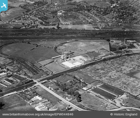
EPW044846 ENGLAND (1934). The Heinz Food Factory, Grand Union Canal and environs, Harlesden, 1934
© Copyright OpenStreetMap contributors and licensed by the OpenStreetMap Foundation. 2026. Cartography is licensed as CC BY-SA.
Nearby Images (38)
EPW044846

EPW044847

EPW056368

EPW044849

EPW044844

EPW025122

EPW044841

EPW025218

EPW025125

EPW025083

EPW025079

EPW025086

EPW025081

EPW044848

EPW032155

EPW025082

EPW025084

EPW025076

EPW025078

EPW025087

EPW020205

EPW025215

EPW025217

EPW025216

EPW025124

EPW044842

EPW044843

EPW025221

EPW025214

EPW044850

EPW025077

EPW025123

EPW044851

EPW025085

EPW025219

EPW022718

EPW044845

EPW044840

Details
| Title | [EPW044846] The Heinz Food Factory, Grand Union Canal and environs, Harlesden, 1934 |
| Reference | EPW044846 |
| Date | June-1934 |
| Link | |
| Place name | HARLESDEN |
| Parish | |
| District | |
| Country | ENGLAND |
| Easting / Northing | 520007, 183443 |
| Longitude / Latitude | -0.26949679031287, 51.536637746422 |
| National Grid Reference | TQ200834 |
Pins
Be the first to add a comment to this image!
User Comment Contributions
Stonebridge Park 1934 |

classicforever |
Friday 2nd of August 2013 06:37:16 PM |