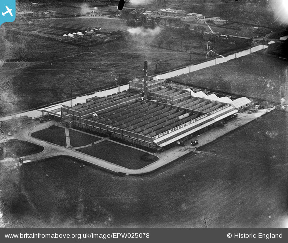
EPW025078 ENGLAND (1928). The Heinz Food Production Works, Stonebridge, 1928
© Copyright OpenStreetMap contributors and licensed by the OpenStreetMap Foundation. 2026. Cartography is licensed as CC BY-SA.
Nearby Images (38)
Details
| Title | [EPW025078] The Heinz Food Production Works, Stonebridge, 1928 |
| Reference | EPW025078 |
| Date | 19-October-1928 |
| Link | |
| Place name | STONEBRIDGE |
| Parish | |
| District | |
| Country | ENGLAND |
| Easting / Northing | 520116, 183394 |
| Longitude / Latitude | -0.26794250254238, 51.536174130519 |
| National Grid Reference | TQ201834 |
Pins
Be the first to add a comment to this image!


![[EPW025078] The Heinz Food Production Works, Stonebridge, 1928](http://britainfromabove.org.uk/sites/all/libraries/aerofilms-images/public/100x100/EPW/025/EPW025078.jpg)
![[EPW025217] The H. J. Heinz and Co. factory, Harlesden, 1928](http://britainfromabove.org.uk/sites/all/libraries/aerofilms-images/public/100x100/EPW/025/EPW025217.jpg)
![[EPW025216] The H. J. Heinz and Co. factory, Harlesden, 1928](http://britainfromabove.org.uk/sites/all/libraries/aerofilms-images/public/100x100/EPW/025/EPW025216.jpg)
![[EPW025084] The Heinz Food Production Works, Stonebridge, 1928](http://britainfromabove.org.uk/sites/all/libraries/aerofilms-images/public/100x100/EPW/025/EPW025084.jpg)
![[EPW025124] The Heinz Food Production Works, Stonebridge, 1928](http://britainfromabove.org.uk/sites/all/libraries/aerofilms-images/public/100x100/EPW/025/EPW025124.jpg)
![[EPW025076] The Heinz Food Production Works, Stonebridge, 1928](http://britainfromabove.org.uk/sites/all/libraries/aerofilms-images/public/100x100/EPW/025/EPW025076.jpg)
![[EPW025077] The Heinz Food Production Works, Stonebridge, 1928](http://britainfromabove.org.uk/sites/all/libraries/aerofilms-images/public/100x100/EPW/025/EPW025077.jpg)
![[EPW025087] The Heinz Food Production Works, Stonebridge, 1928](http://britainfromabove.org.uk/sites/all/libraries/aerofilms-images/public/100x100/EPW/025/EPW025087.jpg)
![[EPW025123] The Heinz Food Production Works, Stonebridge, 1928](http://britainfromabove.org.uk/sites/all/libraries/aerofilms-images/public/100x100/EPW/025/EPW025123.jpg)
![[EPW025214] The H. J. Heinz and Co. factory, Harlesden, 1928](http://britainfromabove.org.uk/sites/all/libraries/aerofilms-images/public/100x100/EPW/025/EPW025214.jpg)
![[EPW025215] The H. J. Heinz and Co. factory, Harlesden, 1928](http://britainfromabove.org.uk/sites/all/libraries/aerofilms-images/public/100x100/EPW/025/EPW025215.jpg)
![[EPW044843] The Heinz Food Factory and environs, Harlesden, 1934](http://britainfromabove.org.uk/sites/all/libraries/aerofilms-images/public/100x100/EPW/044/EPW044843.jpg)
![[EPW025085] The Heinz Food Production Works, Stonebridge, 1928](http://britainfromabove.org.uk/sites/all/libraries/aerofilms-images/public/100x100/EPW/025/EPW025085.jpg)
![[EPW044851] The Heinz Food Factory and Grand Union Canal, Harlesden, 1934](http://britainfromabove.org.uk/sites/all/libraries/aerofilms-images/public/100x100/EPW/044/EPW044851.jpg)
![[EPW025219] The H. J. Heinz and Co. factory, Harlesden, 1928](http://britainfromabove.org.uk/sites/all/libraries/aerofilms-images/public/100x100/EPW/025/EPW025219.jpg)
![[EPW025221] The H. J. Heinz and Co. factory, Harlesden, 1928](http://britainfromabove.org.uk/sites/all/libraries/aerofilms-images/public/100x100/EPW/025/EPW025221.jpg)
![[EPW025082] The Heinz Food Production Works, Stonebridge, 1928](http://britainfromabove.org.uk/sites/all/libraries/aerofilms-images/public/100x100/EPW/025/EPW025082.jpg)
![[EPW044841] The Heinz Food Factory, Grand Union Canal and environs, Harlesden, 1934](http://britainfromabove.org.uk/sites/all/libraries/aerofilms-images/public/100x100/EPW/044/EPW044841.jpg)
![[EPW025218] The H. J. Heinz and Co. factory, Harlesden, 1928](http://britainfromabove.org.uk/sites/all/libraries/aerofilms-images/public/100x100/EPW/025/EPW025218.jpg)
![[EPW044850] The Heinz Food Factory, Harlesden, 1934](http://britainfromabove.org.uk/sites/all/libraries/aerofilms-images/public/100x100/EPW/044/EPW044850.jpg)
![[EPW025083] The Heinz Food Production Works, Stonebridge, 1928](http://britainfromabove.org.uk/sites/all/libraries/aerofilms-images/public/100x100/EPW/025/EPW025083.jpg)
![[EPW025122] The Heinz Food Production Works, Stonebridge, 1928](http://britainfromabove.org.uk/sites/all/libraries/aerofilms-images/public/100x100/EPW/025/EPW025122.jpg)
![[EPW032155] The Heinz Food Production Works, Stonebridge, 1930](http://britainfromabove.org.uk/sites/all/libraries/aerofilms-images/public/100x100/EPW/032/EPW032155.jpg)
![[EPW044845] The Heinz Food Factory, Grand Union Canal and environs, Harlesden, 1934](http://britainfromabove.org.uk/sites/all/libraries/aerofilms-images/public/100x100/EPW/044/EPW044845.jpg)
![[EPW044840] The Heinz Food Factory, Grand Union Canal and environs, Harlesden, 1934](http://britainfromabove.org.uk/sites/all/libraries/aerofilms-images/public/100x100/EPW/044/EPW044840.jpg)
![[EPW025086] The Heinz Food Production Works, Stonebridge, 1928](http://britainfromabove.org.uk/sites/all/libraries/aerofilms-images/public/100x100/EPW/025/EPW025086.jpg)
![[EPW020205] The Heinz Food Production Factory, Stonebridge, 1928](http://britainfromabove.org.uk/sites/all/libraries/aerofilms-images/public/100x100/EPW/020/EPW020205.jpg)
![[EPW022718] The Heinz Food Production Factory, Lower Place, 1928](http://britainfromabove.org.uk/sites/all/libraries/aerofilms-images/public/100x100/EPW/022/EPW022718.jpg)
![[EPW044844] The Heinz Food Factory, Grand Union Canal and environs, Harlesden, 1934](http://britainfromabove.org.uk/sites/all/libraries/aerofilms-images/public/100x100/EPW/044/EPW044844.jpg)
![[EPW025081] The Heinz Food Production Works, Stonebridge, 1928](http://britainfromabove.org.uk/sites/all/libraries/aerofilms-images/public/100x100/EPW/025/EPW025081.jpg)
![[EPW044842] The Heinz Food Factory, Grand Union Canal and environs, Harlesden, 1934](http://britainfromabove.org.uk/sites/all/libraries/aerofilms-images/public/100x100/EPW/044/EPW044842.jpg)
![[EPW044847] The Heinz Food Factory, Grand Union Canal and environs, Harlesden, 1934](http://britainfromabove.org.uk/sites/all/libraries/aerofilms-images/public/100x100/EPW/044/EPW044847.jpg)
![[EPW044849] The Heinz Food Factory, Grand Union Canal and environs, Harlesden, 1934](http://britainfromabove.org.uk/sites/all/libraries/aerofilms-images/public/100x100/EPW/044/EPW044849.jpg)
![[EPW025125] The Heinz Food Production Works, Stonebridge, 1928](http://britainfromabove.org.uk/sites/all/libraries/aerofilms-images/public/100x100/EPW/025/EPW025125.jpg)
![[EPW025079] The Heinz Food Production Works, Stonebridge, 1928](http://britainfromabove.org.uk/sites/all/libraries/aerofilms-images/public/100x100/EPW/025/EPW025079.jpg)
![[EPW044846] The Heinz Food Factory, Grand Union Canal and environs, Harlesden, 1934](http://britainfromabove.org.uk/sites/all/libraries/aerofilms-images/public/100x100/EPW/044/EPW044846.jpg)
![[EPW044848] The Heinz Food Factory and Grand Union Canal, Harlesden, 1934](http://britainfromabove.org.uk/sites/all/libraries/aerofilms-images/public/100x100/EPW/044/EPW044848.jpg)
![[EPW056368] The Heinz Food Production Factory, Stonebridge, 1938](http://britainfromabove.org.uk/sites/all/libraries/aerofilms-images/public/100x100/EPW/056/EPW056368.jpg)