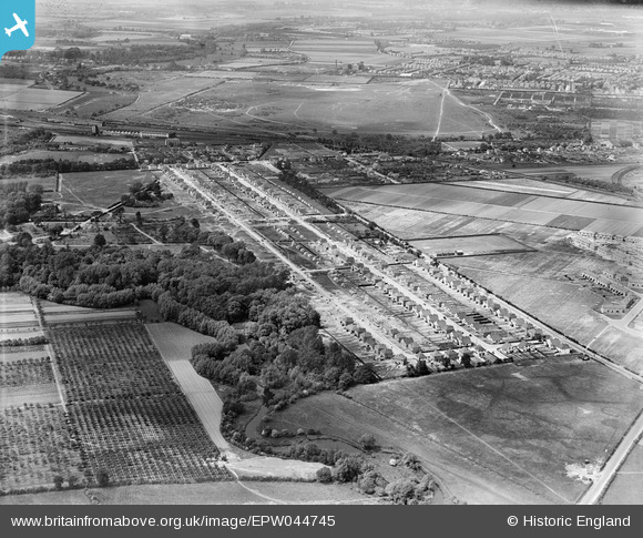
EPW044745 ENGLAND (1934). The River Crane, Powder Mill Lane and housing under construction along Waverley Avenue and Lyndhurst Avenue, Twickenham, from the south-east, 1934
    © Copyright OpenStreetMap contributors and licensed by the OpenStreetMap Foundation. 2025. Cartography is licensed as CC BY-SA.
  
Details
| Title | [EPW044745] The River Crane, Powder Mill Lane and housing under construction along Waverley Avenue and Lyndhurst Avenue, Twickenham, from the south-east, 1934 | 
| Reference | EPW044745 | 
| Date | July-1934 | 
| Link | |
| Place name | TWICKENHAM | 
| Parish | |
| District | |
| Country | ENGLAND | 
| Easting / Northing | 513377, 172900 | 
| Longitude / Latitude | -0.36844557499533, 51.443238993182 | 
| National Grid Reference | TQ134729 | 
Pins
Be the first to add a comment to this image!
 
             
  ![[EPW044745] The River Crane, Powder Mill Lane and housing under construction along Waverley Avenue and Lyndhurst Avenue, Twickenham, from the south-east, 1934](http://britainfromabove.org.uk/sites/all/libraries/aerofilms-images/public/100x100/EPW/044/EPW044745.jpg) 
  
                                          ![[EPW044748] Powder Mill Lane and housing under construction along Waverley Avenue and Lyndhurst Avenue, Twickenham, 1934](http://britainfromabove.org.uk/sites/all/libraries/aerofilms-images/public/100x100/EPW/044/EPW044748.jpg) 
 ![[EPW044743] Powder Mill Lane and housing under construction along Waverley Avenue and Lyndhurst Avenue, Twickenham, 1934](http://britainfromabove.org.uk/sites/all/libraries/aerofilms-images/public/100x100/EPW/044/EPW044743.jpg) 
 ![[EPW044747] Powder Mill Lane and housing under construction along Waverley Avenue and Lyndhurst Avenue, Twickenham, 1934](http://britainfromabove.org.uk/sites/all/libraries/aerofilms-images/public/100x100/EPW/044/EPW044747.jpg)