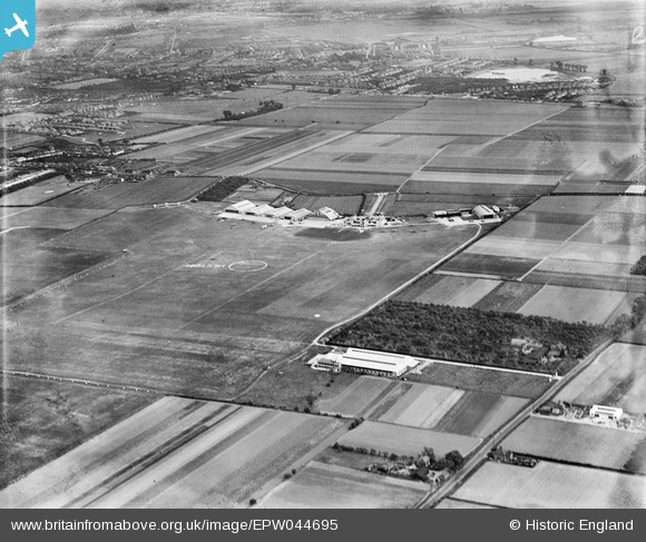
EPW044695 ENGLAND (1934). Heston Aerodrome and environs, Heston, 1934
© Copyright OpenStreetMap contributors and licensed by the OpenStreetMap Foundation. 2026. Cartography is licensed as CC BY-SA.
Nearby Images (48)
Details
| Title | [EPW044695] Heston Aerodrome and environs, Heston, 1934 |
| Reference | EPW044695 |
| Date | May-1934 |
| Link | |
| Place name | HESTON |
| Parish | |
| District | |
| Country | ENGLAND |
| Easting / Northing | 511298, 177923 |
| Longitude / Latitude | -0.3967688574917, 51.488803378764 |
| National Grid Reference | TQ113779 |
Pins
Be the first to add a comment to this image!


![[EPW044695] Heston Aerodrome and environs, Heston, 1934](http://britainfromabove.org.uk/sites/all/libraries/aerofilms-images/public/100x100/EPW/044/EPW044695.jpg)
![[EPW037987] Heston, aircraft lined up for the start of The Morning Post Cross-Country Air Race at Heston Aerodrome, 1932](http://britainfromabove.org.uk/sites/all/libraries/aerofilms-images/public/100x100/EPW/037/EPW037987.jpg)
![[EPW037991] Heston, aircraft lined up for the start of The Morning Post Cross-Country Air Race at Heston Aerodrome, 1932](http://britainfromabove.org.uk/sites/all/libraries/aerofilms-images/public/100x100/EPW/037/EPW037991.jpg)
![[EPW037992] Heston, aircraft lined up for the start of The Morning Post Cross-Country Air Race at Heston Aerodrome, from the north-west, 1932](http://britainfromabove.org.uk/sites/all/libraries/aerofilms-images/public/100x100/EPW/037/EPW037992.jpg)
![[EPW034901] DH60G Gipsy Moth G-AAKE flying above Heston Air Park, Heston, 1931](http://britainfromabove.org.uk/sites/all/libraries/aerofilms-images/public/100x100/EPW/034/EPW034901.jpg)
![[EPW037993] Heston, aircraft lined up for the start of The Morning Post Cross-Country Air Race at Heston Aerodrome, from the north-west, 1932](http://britainfromabove.org.uk/sites/all/libraries/aerofilms-images/public/100x100/EPW/037/EPW037993.jpg)
![[EPW037940] Heston, Household Brigade Flying Club Meeting at Heston Airport, 1932](http://britainfromabove.org.uk/sites/all/libraries/aerofilms-images/public/100x100/EPW/037/EPW037940.jpg)
![[EPW033757] Heston Air Park, Heston, from the north, 1930](http://britainfromabove.org.uk/sites/all/libraries/aerofilms-images/public/100x100/EPW/033/EPW033757.jpg)
![[EPW037988] Heston, aircraft lined up for the start of The Morning Post Cross-Country Air Race at Heston Aerodrome, from the north, 1932](http://britainfromabove.org.uk/sites/all/libraries/aerofilms-images/public/100x100/EPW/037/EPW037988.jpg)
![[EPW037990] Heston, aircraft lined up for the start of The Morning Post Cross-Country Air Race at Heston Aerodrome, from the north, 1932](http://britainfromabove.org.uk/sites/all/libraries/aerofilms-images/public/100x100/EPW/037/EPW037990.jpg)
![[EPW033767] Heston Air Park, Heston, from the north, 1930](http://britainfromabove.org.uk/sites/all/libraries/aerofilms-images/public/100x100/EPW/033/EPW033767.jpg)
![[EPW025552] The site of Heston Aerodrome, Heston, 1928. This image has been produced from a print.](http://britainfromabove.org.uk/sites/all/libraries/aerofilms-images/public/100x100/EPW/025/EPW025552.jpg)
![[EPW031234] Heston, the Gloster Survey Aeroplane (G-AADO) at Heston Air Park, 1930](http://britainfromabove.org.uk/sites/all/libraries/aerofilms-images/public/100x100/EPW/031/EPW031234.jpg)
![[EPW031236] Heston, the Gloster Survey Aeroplane (G-AADO) at Heston Air Park, 1930](http://britainfromabove.org.uk/sites/all/libraries/aerofilms-images/public/100x100/EPW/031/EPW031236.jpg)
![[EPW031239] Heston, the Gloster Survey Aeroplane (G-AADO) at Heston Air Park, 1930](http://britainfromabove.org.uk/sites/all/libraries/aerofilms-images/public/100x100/EPW/031/EPW031239.jpg)
![[EPW053979] Heston Aerodrome, Heston, 1937. This image has been produced from a damaged negative.](http://britainfromabove.org.uk/sites/all/libraries/aerofilms-images/public/100x100/EPW/053/EPW053979.jpg)
![[EPW041420] Aircraft assembled for the second Morning Post Cross-Country Air Race, Heston, from the south-west, 1933](http://britainfromabove.org.uk/sites/all/libraries/aerofilms-images/public/100x100/EPW/041/EPW041420.jpg)
![[EPW036120] Heston, the King's Cup Race competitors' aircraft assembled on the airfield, 1931](http://britainfromabove.org.uk/sites/all/libraries/aerofilms-images/public/100x100/EPW/036/EPW036120.jpg)
![[EPW040093] A Handley Page H.P. 42 Heracles passenger plane G-AAXC in flight over Heston Airport, Heston, 1932](http://britainfromabove.org.uk/sites/all/libraries/aerofilms-images/public/100x100/EPW/040/EPW040093.jpg)
![[EPW037337] Heston Airport, Heston, from the north-west, 1932](http://britainfromabove.org.uk/sites/all/libraries/aerofilms-images/public/100x100/EPW/037/EPW037337.jpg)
![[EPW037936] Heston, Household Brigade Flying Club Meeting at Heston Airport, 1932](http://britainfromabove.org.uk/sites/all/libraries/aerofilms-images/public/100x100/EPW/037/EPW037936.jpg)
![[EPW034935] Heston Airport, Heston, from the south, 1931. This image has been produced from a copy-negative.](http://britainfromabove.org.uk/sites/all/libraries/aerofilms-images/public/100x100/EPW/034/EPW034935.jpg)
![[EPW037938] Heston, Household Brigade Flying Club Meeting at Heston Airport, 1932](http://britainfromabove.org.uk/sites/all/libraries/aerofilms-images/public/100x100/EPW/037/EPW037938.jpg)
![[EPW028591] The Heston Air Park, Heston, 1929](http://britainfromabove.org.uk/sites/all/libraries/aerofilms-images/public/100x100/EPW/028/EPW028591.jpg)
![[EPW038202] Handley Page HP.42W Western 42/5 G-AAXD "Horatius" and other aircraft at Heston Aerodrome, Heston, 1932](http://britainfromabove.org.uk/sites/all/libraries/aerofilms-images/public/100x100/EPW/038/EPW038202.jpg)
![[EPW036078] Heston, the Household Brigade Flying Club meeting at Heston Air Park, 1931](http://britainfromabove.org.uk/sites/all/libraries/aerofilms-images/public/100x100/EPW/036/EPW036078.jpg)
![[EPW037522] Heston Airport buildings with De Havilland DH60G "Gipsy Moth" aircraft G-ABEO on the airfield, Heston, 1932](http://britainfromabove.org.uk/sites/all/libraries/aerofilms-images/public/100x100/EPW/037/EPW037522.jpg)
![[EPW033763] Hangar and terminal buildings at Heston Air Park, Heston, 1930](http://britainfromabove.org.uk/sites/all/libraries/aerofilms-images/public/100x100/EPW/033/EPW033763.jpg)
![[EPW034842] Heston, Mrs Victor Bruce arrives at Heston Aerodrome in a Blackburn Bluebird IV (G-ABDS) after completing her world solo flight, 1931](http://britainfromabove.org.uk/sites/all/libraries/aerofilms-images/public/100x100/EPW/034/EPW034842.jpg)
![[EPW038201] Handley Page HP.42W Western 42/5 G-AAXD "Horatius" and other aircraft at Heston Aerodrome, Heston, 1932](http://britainfromabove.org.uk/sites/all/libraries/aerofilms-images/public/100x100/EPW/038/EPW038201.jpg)
![[EPW038205] Handley Page HP.42W Western 42/5 G-AAXD "Horatius" and other aircraft at Heston Aerodrome, Heston, 1932](http://britainfromabove.org.uk/sites/all/libraries/aerofilms-images/public/100x100/EPW/038/EPW038205.jpg)
![[EPW037523] Heston Airport buildings with De Havilland DH60G "Gipsy Moth" aircraft G-ABEO on the airfield, Heston, 1932](http://britainfromabove.org.uk/sites/all/libraries/aerofilms-images/public/100x100/EPW/037/EPW037523.jpg)
![[EPW040089] Heston Airport, Heston, 1932](http://britainfromabove.org.uk/sites/all/libraries/aerofilms-images/public/100x100/EPW/040/EPW040089.jpg)
![[EPW040092] Heston Airport, Heston, 1932](http://britainfromabove.org.uk/sites/all/libraries/aerofilms-images/public/100x100/EPW/040/EPW040092.jpg)
![[EPW040094] Heston Airport, Heston, 1932](http://britainfromabove.org.uk/sites/all/libraries/aerofilms-images/public/100x100/EPW/040/EPW040094.jpg)
![[EPW031403] Heston Air Park Hangars with biplanes on the airfield, Heston, 1930](http://britainfromabove.org.uk/sites/all/libraries/aerofilms-images/public/100x100/EPW/031/EPW031403.jpg)
![[EPW037586] Heston Airport buildings, Heston, 1932](http://britainfromabove.org.uk/sites/all/libraries/aerofilms-images/public/100x100/EPW/037/EPW037586.jpg)
![[EPW053980] Heston Aerodrome, Heston, 1937](http://britainfromabove.org.uk/sites/all/libraries/aerofilms-images/public/100x100/EPW/053/EPW053980.jpg)
![[EPW037935] Heston, Household Brigade Flying Club Meeting at Heston Airport, 1932](http://britainfromabove.org.uk/sites/all/libraries/aerofilms-images/public/100x100/EPW/037/EPW037935.jpg)
![[EPW037585] Heston Airport buildings, Heston, 1932](http://britainfromabove.org.uk/sites/all/libraries/aerofilms-images/public/100x100/EPW/037/EPW037585.jpg)
![[EPW035529] Heston Aerodrome, Heston, 1931](http://britainfromabove.org.uk/sites/all/libraries/aerofilms-images/public/100x100/EPW/035/EPW035529.jpg)
![[EPW037941] Heston, Household Brigade Flying Club Meeting at Heston Airport, 1932](http://britainfromabove.org.uk/sites/all/libraries/aerofilms-images/public/100x100/EPW/037/EPW037941.jpg)
![[EPW041419] Aircraft assembled for the second Morning Post Cross-Country Air Race, Heston, from the west, 1933](http://britainfromabove.org.uk/sites/all/libraries/aerofilms-images/public/100x100/EPW/041/EPW041419.jpg)
![[EPW043685] Comper Aircraft Company Workshop at Heston Aerodrome, Heston, 1933](http://britainfromabove.org.uk/sites/all/libraries/aerofilms-images/public/100x100/EPW/043/EPW043685.jpg)
![[EPW043681] Comper Aircraft Company Workshop at Heston Aerodrome, Heston, 1933](http://britainfromabove.org.uk/sites/all/libraries/aerofilms-images/public/100x100/EPW/043/EPW043681.jpg)
![[EPW043683] Comper Aircraft Company Workshop at Heston Aerodrome, Heston, 1933](http://britainfromabove.org.uk/sites/all/libraries/aerofilms-images/public/100x100/EPW/043/EPW043683.jpg)
![[EAW039264] The Heston Aircraft Co Factory at Heston Airport, Hounslow, 1951. This image has been produced from a print marked by Aerofilms Ltd for photo editing.](http://britainfromabove.org.uk/sites/all/libraries/aerofilms-images/public/100x100/EAW/039/EAW039264.jpg)
![[EAW039269] The Heston Aircraft Co Factory at Heston Airport, Hounslow, 1951. This image has been produced from a print marked by Aerofilms Ltd for photo editing.](http://britainfromabove.org.uk/sites/all/libraries/aerofilms-images/public/100x100/EAW/039/EAW039269.jpg)