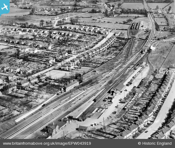
EPW043919 ENGLAND (1934). Upminster Railway Station and environs, Upminster, 1934
© Copyright OpenStreetMap contributors and licensed by the OpenStreetMap Foundation. 2025. Cartography is licensed as CC BY-SA.
Nearby Images (8)
Details
| Title | [EPW043919] Upminster Railway Station and environs, Upminster, 1934 |
| Reference | EPW043919 |
| Date | March-1934 |
| Link | |
| Place name | UPMINSTER |
| Parish | |
| District | |
| Country | ENGLAND |
| Easting / Northing | 556430, 186918 |
| Longitude / Latitude | 0.25688159474986, 51.558944061457 |
| National Grid Reference | TQ564869 |
Pins

John Wass |
Monday 22nd of June 2015 03:38:23 PM | |

John Wass |
Monday 22nd of June 2015 03:37:13 PM | |

GeoffR |
Thursday 15th of January 2015 05:22:48 PM | |

GeoffR |
Thursday 15th of January 2015 05:21:27 PM | |

GeoffR |
Thursday 15th of January 2015 05:19:59 PM | |

GeoffR |
Thursday 15th of January 2015 05:19:27 PM | |

GeoffR |
Thursday 15th of January 2015 05:18:53 PM | |

GeoffR |
Thursday 15th of January 2015 05:17:14 PM | |

GeoffR |
Thursday 15th of January 2015 05:07:44 PM |


![[EPW043919] Upminster Railway Station and environs, Upminster, 1934](http://britainfromabove.org.uk/sites/all/libraries/aerofilms-images/public/100x100/EPW/043/EPW043919.jpg)
![[EPW043925] Upminster Railway Station Engine Shed, Deyncourt Gardens and environs, Upminster, 1934](http://britainfromabove.org.uk/sites/all/libraries/aerofilms-images/public/100x100/EPW/043/EPW043925.jpg)
![[EPW043847] Upminster Railway Station and environs, Upminster, 1934](http://britainfromabove.org.uk/sites/all/libraries/aerofilms-images/public/100x100/EPW/043/EPW043847.jpg)
![[EPW043848] Upminster Railway Station and environs, Upminster, 1934](http://britainfromabove.org.uk/sites/all/libraries/aerofilms-images/public/100x100/EPW/043/EPW043848.jpg)
![[EPW043850] Station Road, housing development around Sunnyside Gardens and environs, Upminster, 1934](http://britainfromabove.org.uk/sites/all/libraries/aerofilms-images/public/100x100/EPW/043/EPW043850.jpg)
![[EPW043923] Upminster Railway Station and environs, Upminster, 1934](http://britainfromabove.org.uk/sites/all/libraries/aerofilms-images/public/100x100/EPW/043/EPW043923.jpg)
![[EPW043852] Housing development around Sunnyside Gardens and environs, Upminster, 1934](http://britainfromabove.org.uk/sites/all/libraries/aerofilms-images/public/100x100/EPW/043/EPW043852.jpg)
![[EPW043846] Upminster Railway Station and the town, Upminster, 1934](http://britainfromabove.org.uk/sites/all/libraries/aerofilms-images/public/100x100/EPW/043/EPW043846.jpg)