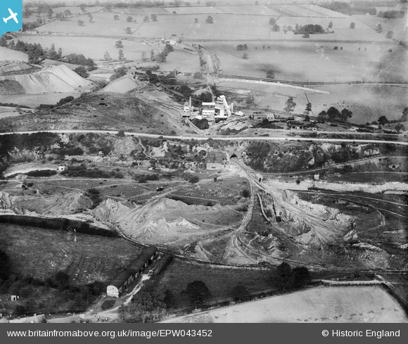
EPW043452 ENGLAND (1933). The Hartshill Quarries, Hartshill, 1933
© Copyright OpenStreetMap contributors and licensed by the OpenStreetMap Foundation. 2025. Cartography is licensed as CC BY-SA.
Nearby Images (10)
Details
| Title | [EPW043452] The Hartshill Quarries, Hartshill, 1933 |
| Reference | EPW043452 |
| Date | October-1933 |
| Link | |
| Place name | HARTSHILL |
| Parish | HARTSHILL |
| District | |
| Country | ENGLAND |
| Easting / Northing | 433299, 294212 |
| Longitude / Latitude | -1.5089219339774, 52.544379638704 |
| National Grid Reference | SP333942 |
Pins
Be the first to add a comment to this image!


![[EPW043452] The Hartshill Quarries, Hartshill, 1933](http://britainfromabove.org.uk/sites/all/libraries/aerofilms-images/public/100x100/EPW/043/EPW043452.jpg)
![[EPW043453] The Hartshill Quarries, Hartshill, 1933](http://britainfromabove.org.uk/sites/all/libraries/aerofilms-images/public/100x100/EPW/043/EPW043453.jpg)
![[EPW043451] The Hartshill Quarries, Hartshill, 1933](http://britainfromabove.org.uk/sites/all/libraries/aerofilms-images/public/100x100/EPW/043/EPW043451.jpg)
![[EPW043449] The Hartshill Quarries, Hartshill, 1933](http://britainfromabove.org.uk/sites/all/libraries/aerofilms-images/public/100x100/EPW/043/EPW043449.jpg)
![[EPW043454] The Hartshill Quarries, Hartshill, 1933](http://britainfromabove.org.uk/sites/all/libraries/aerofilms-images/public/100x100/EPW/043/EPW043454.jpg)
![[EPW043455] The Hartshill Quarries, Hartshill, 1933](http://britainfromabove.org.uk/sites/all/libraries/aerofilms-images/public/100x100/EPW/043/EPW043455.jpg)
![[EPW043450] The Hartshill Quarries, Hartshill, 1933](http://britainfromabove.org.uk/sites/all/libraries/aerofilms-images/public/100x100/EPW/043/EPW043450.jpg)
![[EPW042882] Jees Granite and Brick Company Hartshill Quarries and surrounding countryside, Hartshill, 1933](http://britainfromabove.org.uk/sites/all/libraries/aerofilms-images/public/100x100/EPW/042/EPW042882.jpg)
![[EPW042886] Jees Granite and Brick Company Hartshill Quarries and surrounding countryside, Hartshill, 1933](http://britainfromabove.org.uk/sites/all/libraries/aerofilms-images/public/100x100/EPW/042/EPW042886.jpg)
![[EPW043456] The Hartshill Quarries, Hartshill, from the south-west, 1933](http://britainfromabove.org.uk/sites/all/libraries/aerofilms-images/public/100x100/EPW/043/EPW043456.jpg)