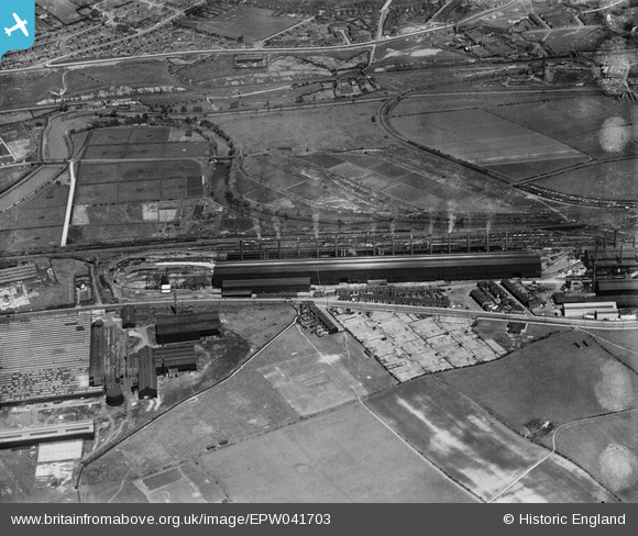
EPW041703 ENGLAND (1933). The Templeborough Steel Works and environs, Rotherham, 1933
© Copyright OpenStreetMap contributors and licensed by the OpenStreetMap Foundation. 2026. Cartography is licensed as CC BY-SA.
Nearby Images (11)
Details
| Title | [EPW041703] The Templeborough Steel Works and environs, Rotherham, 1933 |
| Reference | EPW041703 |
| Date | June-1933 |
| Link | |
| Place name | ROTHERHAM |
| Parish | |
| District | |
| Country | ENGLAND |
| Easting / Northing | 440724, 391566 |
| Longitude / Latitude | -1.3871667104178, 53.419062115803 |
| National Grid Reference | SK407916 |


![[EPW041703] The Templeborough Steel Works and environs, Rotherham, 1933](http://britainfromabove.org.uk/sites/all/libraries/aerofilms-images/public/100x100/EPW/041/EPW041703.jpg)
![[EAW029393] The Steel, Peech and Tozer Templeborough Steel Works, Ickles, 1950](http://britainfromabove.org.uk/sites/all/libraries/aerofilms-images/public/100x100/EAW/029/EAW029393.jpg)
![[EAW025969] The Templeborough Steel Works, Templeborough, 1949. This image has been produced from a print.](http://britainfromabove.org.uk/sites/all/libraries/aerofilms-images/public/100x100/EAW/025/EAW025969.jpg)
![[EAW029398] The River Don and the Steel, Peech and Tozer Templeborough Steel Works, Ickles, 1950](http://britainfromabove.org.uk/sites/all/libraries/aerofilms-images/public/100x100/EAW/029/EAW029398.jpg)
![[EAW030490] The Steel, Peech and Tozer Templeborough Steel Works and environs, Templeborough, 1950](http://britainfromabove.org.uk/sites/all/libraries/aerofilms-images/public/100x100/EAW/030/EAW030490.jpg)
![[EAW025973] The Templeborough Steel Works, Templeborough, 1949. This image has been produced from a print marked by Aerofilms Ltd for photo editing.](http://britainfromabove.org.uk/sites/all/libraries/aerofilms-images/public/100x100/EAW/025/EAW025973.jpg)
![[EAW030491] The Steel, Peech and Tozer Templeborough Steel Works, Templeborough, 1950](http://britainfromabove.org.uk/sites/all/libraries/aerofilms-images/public/100x100/EAW/030/EAW030491.jpg)
![[EAW024154] The Steel, Peech and Tozer Templeborough Steel Works, Templeborough, from the south-west, 1949](http://britainfromabove.org.uk/sites/all/libraries/aerofilms-images/public/100x100/EAW/024/EAW024154.jpg)
![[EAW030484] The Steel, Peech and Tozer Templeborough Steel Works and environs, Templeborough, 1950](http://britainfromabove.org.uk/sites/all/libraries/aerofilms-images/public/100x100/EAW/030/EAW030484.jpg)
![[EAW030483] The Steel, Peech and Tozer Templeborough Steel Works and environs, Templeborough, 1950](http://britainfromabove.org.uk/sites/all/libraries/aerofilms-images/public/100x100/EAW/030/EAW030483.jpg)
![[EPW041706] The Templeborough Steel Works alongside the River Don, Rotherham, 1933](http://britainfromabove.org.uk/sites/all/libraries/aerofilms-images/public/100x100/EPW/041/EPW041706.jpg)