
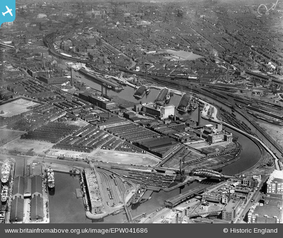
EPW041686 ENGLAND (1933). The Pomona Docks alongside the Manchester Ship Canal and environs, Old Trafford, 1933
© Copyright OpenStreetMap contributors and licensed by the OpenStreetMap Foundation. 2026. Cartography is licensed as CC BY-SA.
Nearby Images (18)
EPW041686

EPW045991

EPW008986

EPW036819

EPW008987

EPW008990

EPW008991

EPW008989

EPW008988

EPW008985

EPW027780

EPW027779

EAW050415

EPW016770

EPW016776

EPW016771

EPW045068

EPW016774

Details
| Title | [EPW041686] The Pomona Docks alongside the Manchester Ship Canal and environs, Old Trafford, 1933 |
| Reference | EPW041686 |
| Date | June-1933 |
| Link | |
| Place name | OLD TRAFFORD |
| Parish | |
| District | |
| Country | ENGLAND |
| Easting / Northing | 381840, 396853 |
| Longitude / Latitude | -2.2735919963097, 53.467848867946 |
| National Grid Reference | SJ818969 |
Pins

Crispin Edwards |
Tuesday 7th of April 2026 11:20:11 AM | |
|
Crispin Edwards |
Tuesday 7th of April 2026 11:19:23 AM | |
|
Crispin Edwards |
Tuesday 7th of April 2026 11:18:55 AM | |
|
Crispin Edwards |
Tuesday 7th of April 2026 11:18:20 AM | |
|
Crispin Edwards |
Tuesday 7th of April 2026 11:18:00 AM | |
|
Crispin Edwards |
Tuesday 7th of April 2026 11:17:22 AM | |
|
Crispin Edwards |
Tuesday 7th of April 2026 11:17:05 AM | |
|
Stretfordian |
Thursday 7th of March 2019 03:50:43 PM | |
|
Stretfordian |
Thursday 7th of March 2019 03:49:49 PM | |
|
Stretfordian |
Thursday 7th of March 2019 03:49:04 PM | |
|
Stretfordian |
Thursday 7th of March 2019 03:47:52 PM |