
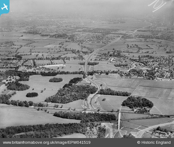
EPW041519 ENGLAND (1933). Wythenshawe Park and the Princess Parkway under construction, Wythenshawe, from the south, 1933
© Copyright OpenStreetMap contributors and licensed by the OpenStreetMap Foundation. 2026. Cartography is licensed as CC BY-SA.
Nearby Images (7)
EPW041519

EPW036814
 under construction at Gib Lane Wood, Wythenshawe, 1931. This image has been produced from a copy-negative.")
EPW041521

EPW041517

EPW041520

EPW041518

EPW041516

Details
| Title | [EPW041519] Wythenshawe Park and the Princess Parkway under construction, Wythenshawe, from the south, 1933 |
| Reference | EPW041519 |
| Date | June-1933 |
| Link | |
| Place name | WYTHENSHAWE |
| Parish | |
| District | |
| Country | ENGLAND |
| Easting / Northing | 382253, 389510 |
| Longitude / Latitude | -2.2669559735492, 53.40185333099 |
| National Grid Reference | SJ823895 |
Pins

MisterB |
Wednesday 18th of February 2026 01:06:26 PM | |
|
John Ellis |
Saturday 18th of January 2014 07:31:11 PM | |
|
John Ellis |
Saturday 18th of January 2014 07:29:53 PM | |
|
John Ellis |
Saturday 18th of January 2014 07:28:53 PM | |
|
John Ellis |
Saturday 18th of January 2014 07:24:33 PM | |
|
John Ellis |
Saturday 18th of January 2014 07:21:52 PM | |
|
John Ellis |
Saturday 18th of January 2014 07:21:07 PM | |
|
John Ellis |
Saturday 18th of January 2014 07:20:35 PM | |
|
John Ellis |
Saturday 18th of January 2014 07:19:22 PM | |
|
John Ellis |
Saturday 18th of January 2014 07:17:31 PM | |
|
John Ellis |
Wednesday 8th of January 2014 10:58:35 AM | |
|
John Ellis |
Wednesday 8th of January 2014 10:57:19 AM | |
|
John Ellis |
Wednesday 8th of January 2014 10:56:13 AM | |
|
John Ellis |
Wednesday 8th of January 2014 10:55:34 AM | |
|
John Ellis |
Wednesday 8th of January 2014 10:54:49 AM | |
|
John Ellis |
Wednesday 8th of January 2014 10:54:12 AM | |
|
John Ellis |
Tuesday 7th of January 2014 05:58:16 PM | |
|
John Ellis |
Tuesday 7th of January 2014 05:57:04 PM | |
|
John Ellis |
Tuesday 7th of January 2014 05:56:24 PM | |
|
John Ellis |
Tuesday 7th of January 2014 05:55:39 PM | |
|
John Ellis |
Tuesday 7th of January 2014 05:54:55 PM | |
|
John Ellis |
Tuesday 7th of January 2014 05:54:27 PM | |
|
John Ellis |
Tuesday 7th of January 2014 05:53:54 PM | |
|
John Ellis |
Tuesday 7th of January 2014 05:53:21 PM | |
|
John Ellis |
Tuesday 7th of January 2014 05:52:17 PM | |
|
John Ellis |
Tuesday 7th of January 2014 05:51:34 PM | |
|
John Ellis |
Tuesday 7th of January 2014 05:50:57 PM | |
|
John Ellis |
Tuesday 7th of January 2014 05:50:27 PM | |
|
John Ellis |
Tuesday 7th of January 2014 05:49:34 PM | |
|
John Ellis |
Tuesday 7th of January 2014 05:47:40 PM | |
|
John Ellis |
Tuesday 7th of January 2014 05:46:59 PM | |
|
John Ellis |
Tuesday 7th of January 2014 05:46:19 PM | |
|
John Ellis |
Tuesday 7th of January 2014 05:45:02 PM | |
|
John Ellis |
Tuesday 7th of January 2014 05:43:34 PM | |
|
John Ellis |
Tuesday 7th of January 2014 05:42:56 PM | |
|
John Ellis |
Tuesday 7th of January 2014 05:42:19 PM | |
|
John Ellis |
Tuesday 7th of January 2014 05:41:46 PM | |
|
John Ellis |
Tuesday 7th of January 2014 05:40:39 PM | |
|
John Ellis |
Tuesday 7th of January 2014 05:37:46 PM | |
|
John Ellis |
Tuesday 7th of January 2014 05:37:15 PM | |
|
John Ellis |
Tuesday 7th of January 2014 05:36:44 PM | |
|
John Ellis |
Tuesday 7th of January 2014 05:36:18 PM | |
|
John Ellis |
Tuesday 7th of January 2014 05:35:41 PM | |
|
John Ellis |
Tuesday 7th of January 2014 05:34:57 PM | |
|
John Ellis |
Tuesday 7th of January 2014 05:33:58 PM | |
|
John Ellis |
Tuesday 7th of January 2014 04:45:41 PM | |
|
John Ellis |
Tuesday 7th of January 2014 04:45:20 PM |