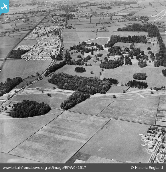
EPW041517 ENGLAND (1933). Wythenshawe Park and the Princess Parkway under construction at Gib Lane Wood, Wythenshawe, 1933
© Copyright OpenStreetMap contributors and licensed by the OpenStreetMap Foundation. 2026. Cartography is licensed as CC BY-SA.
Nearby Images (7)
Details
| Title | [EPW041517] Wythenshawe Park and the Princess Parkway under construction at Gib Lane Wood, Wythenshawe, 1933 |
| Reference | EPW041517 |
| Date | June-1933 |
| Link | |
| Place name | WYTHENSHAWE |
| Parish | |
| District | |
| Country | ENGLAND |
| Easting / Northing | 382143, 389526 |
| Longitude / Latitude | -2.2686115142342, 53.401993452767 |
| National Grid Reference | SJ821895 |
Pins

John Ellis |
Tuesday 7th of January 2014 09:26:36 PM | |

John Ellis |
Tuesday 7th of January 2014 09:11:37 PM | |

John Ellis |
Tuesday 7th of January 2014 09:09:52 PM | |

John Ellis |
Tuesday 7th of January 2014 09:08:57 PM | |

John Ellis |
Tuesday 7th of January 2014 09:07:54 PM | |

John Ellis |
Tuesday 7th of January 2014 09:07:17 PM | |

John Ellis |
Tuesday 7th of January 2014 09:06:35 PM | |

John Ellis |
Tuesday 7th of January 2014 09:06:01 PM | |

John Ellis |
Tuesday 7th of January 2014 09:05:05 PM | |

John Ellis |
Tuesday 7th of January 2014 09:04:08 PM | |

John Ellis |
Tuesday 7th of January 2014 09:02:43 PM | |

John Ellis |
Tuesday 7th of January 2014 09:01:12 PM | |

John Ellis |
Tuesday 7th of January 2014 08:59:40 PM | |

John Ellis |
Tuesday 7th of January 2014 08:58:00 PM | |

John Ellis |
Tuesday 7th of January 2014 08:57:05 PM | |

John Ellis |
Tuesday 7th of January 2014 08:56:26 PM | |

John Ellis |
Tuesday 7th of January 2014 08:54:56 PM | |

John Ellis |
Tuesday 7th of January 2014 08:53:20 PM | |

John Ellis |
Tuesday 7th of January 2014 08:51:34 PM | |

John Ellis |
Tuesday 7th of January 2014 08:50:31 PM | |

John Ellis |
Tuesday 7th of January 2014 08:48:40 PM | |

John Ellis |
Tuesday 7th of January 2014 08:46:51 PM | |

John Ellis |
Tuesday 7th of January 2014 08:44:42 PM | |

John Ellis |
Tuesday 7th of January 2014 08:42:41 PM | |

John Ellis |
Tuesday 7th of January 2014 08:38:05 PM | |

John Ellis |
Tuesday 7th of January 2014 08:37:15 PM | |

John Ellis |
Tuesday 7th of January 2014 08:35:35 PM | |

John Ellis |
Tuesday 7th of January 2014 08:33:41 PM | |

John Ellis |
Tuesday 7th of January 2014 08:30:46 PM | |

John Ellis |
Tuesday 7th of January 2014 08:29:46 PM | |

John Ellis |
Tuesday 7th of January 2014 08:27:20 PM | |

John Ellis |
Tuesday 7th of January 2014 08:26:43 PM | |

John Ellis |
Tuesday 7th of January 2014 08:25:34 PM | |

John Ellis |
Tuesday 7th of January 2014 08:24:12 PM | |

John Ellis |
Tuesday 7th of January 2014 08:23:32 PM | |

John Ellis |
Tuesday 7th of January 2014 08:22:35 PM | |

John Ellis |
Tuesday 7th of January 2014 06:07:47 PM | |

John Ellis |
Tuesday 7th of January 2014 06:07:20 PM | |

John Ellis |
Tuesday 7th of January 2014 06:05:43 PM | |

John Ellis |
Tuesday 7th of January 2014 06:04:53 PM | |

John Ellis |
Tuesday 7th of January 2014 06:03:55 PM | |

John Ellis |
Tuesday 7th of January 2014 06:03:29 PM | |

John Ellis |
Tuesday 7th of January 2014 06:03:02 PM | |

John Ellis |
Tuesday 7th of January 2014 06:02:37 PM | |

John Ellis |
Tuesday 7th of January 2014 06:02:16 PM | |

John Ellis |
Tuesday 7th of January 2014 06:01:50 PM | |

John Ellis |
Tuesday 7th of January 2014 06:01:21 PM | |

John Ellis |
Tuesday 7th of January 2014 06:00:43 PM | |

John Ellis |
Tuesday 7th of January 2014 05:59:57 PM | |

Lee |
Tuesday 29th of October 2013 06:09:17 PM |


![[EPW041517] Wythenshawe Park and the Princess Parkway under construction at Gib Lane Wood, Wythenshawe, 1933](http://britainfromabove.org.uk/sites/all/libraries/aerofilms-images/public/100x100/EPW/041/EPW041517.jpg)
![[EPW041521] Wythenshawe Park and the Princess Parkway under construction, Wythenshawe, from the south, 1933. This image has been produced from a print.](http://britainfromabove.org.uk/sites/all/libraries/aerofilms-images/public/100x100/EPW/041/EPW041521.jpg)
![[EPW041519] Wythenshawe Park and the Princess Parkway under construction, Wythenshawe, from the south, 1933](http://britainfromabove.org.uk/sites/all/libraries/aerofilms-images/public/100x100/EPW/041/EPW041519.jpg)
![[EPW041518] Wythenshawe Park and the Princess Parkway under construction at Gib Lane Wood, Wythenshawe, 1933](http://britainfromabove.org.uk/sites/all/libraries/aerofilms-images/public/100x100/EPW/041/EPW041518.jpg)
![[EPW041516] Wythenshawe Park and the Princess Parkway under construction at Gib Lane Wood, Wythenshawe, 1933](http://britainfromabove.org.uk/sites/all/libraries/aerofilms-images/public/100x100/EPW/041/EPW041516.jpg)
![[EPW036814] Princess Parkway (A5103) under construction at Gib Lane Wood, Wythenshawe, 1931. This image has been produced from a copy-negative.](http://britainfromabove.org.uk/sites/all/libraries/aerofilms-images/public/100x100/EPW/036/EPW036814.jpg)
![[EPW041520] Wythenshawe Park and the Princess Parkway under construction, Wythenshawe, from the south, 1933](http://britainfromabove.org.uk/sites/all/libraries/aerofilms-images/public/100x100/EPW/041/EPW041520.jpg)