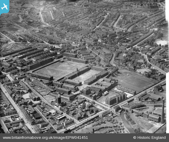
EPW041451 ENGLAND (1933). The Burdall's Buildings (formerly Hillsborough Barracks) and environs, Walkley, 1933
© Copyright OpenStreetMap contributors and licensed by the OpenStreetMap Foundation. 2026. Cartography is licensed as CC BY-SA.
Nearby Images (7)
Details
| Title | [EPW041451] The Burdall's Buildings (formerly Hillsborough Barracks) and environs, Walkley, 1933 |
| Reference | EPW041451 |
| Date | June-1933 |
| Link | |
| Place name | WALKLEY |
| Parish | |
| District | |
| Country | ENGLAND |
| Easting / Northing | 433568, 389577 |
| Longitude / Latitude | -1.4950601704738, 53.401686482172 |
| National Grid Reference | SK336896 |
Pins

Mick Downes |
Thursday 6th of March 2025 09:20:41 PM | |

highsidedvehicles |
Tuesday 31st of August 2021 02:50:48 PM | |

Class31 |
Thursday 12th of May 2016 10:21:21 PM | |

Class31 |
Thursday 12th of May 2016 10:19:10 PM | |

Class31 |
Thursday 12th of May 2016 10:16:38 PM | |

Class31 |
Thursday 12th of May 2016 10:12:01 PM | |

Class31 |
Thursday 12th of May 2016 10:07:01 PM | |

Class31 |
Thursday 12th of May 2016 10:04:33 PM | |

neddy |
Tuesday 26th of April 2016 08:58:06 PM | |

Ace |
Wednesday 19th of August 2015 11:18:01 PM | |

Ace |
Wednesday 19th of August 2015 11:17:38 PM | |

Ace |
Wednesday 19th of August 2015 11:16:54 PM | |

Ace |
Wednesday 19th of August 2015 11:16:31 PM | |

Ace |
Wednesday 19th of August 2015 11:14:55 PM | |

Ace |
Wednesday 19th of August 2015 11:13:55 PM | |

Class31 |
Monday 20th of July 2015 01:52:53 PM |


![[EPW041451] The Burdall's Buildings (formerly Hillsborough Barracks) and environs, Walkley, 1933](http://britainfromabove.org.uk/sites/all/libraries/aerofilms-images/public/100x100/EPW/041/EPW041451.jpg)
![[EPW041450] The Burdall's Buildings (formerly Hillsborough Barracks) and environs, Walkley, 1933](http://britainfromabove.org.uk/sites/all/libraries/aerofilms-images/public/100x100/EPW/041/EPW041450.jpg)
![[EPW041454] The Burdall's Buildings (formerly Hillsborough Barracks), Walkley, 1933](http://britainfromabove.org.uk/sites/all/libraries/aerofilms-images/public/100x100/EPW/041/EPW041454.jpg)
![[EPW041626] Hillsborough Barracks, Hillsborough Park and environs, Sheffield, 1933](http://britainfromabove.org.uk/sites/all/libraries/aerofilms-images/public/100x100/EPW/041/EPW041626.jpg)
![[EPW041452] The Burdall's Buildings (formerly Hillsborough Barracks), Walkley, 1933](http://britainfromabove.org.uk/sites/all/libraries/aerofilms-images/public/100x100/EPW/041/EPW041452.jpg)
![[EPW041449] The Burdall's Buildings (formerly Hillsborough Barracks) and environs, Walkley, 1933](http://britainfromabove.org.uk/sites/all/libraries/aerofilms-images/public/100x100/EPW/041/EPW041449.jpg)
![[EPW041453] The Burdall's Buildings (formerly Hillsborough Barracks) and environs, Walkley, 1933](http://britainfromabove.org.uk/sites/all/libraries/aerofilms-images/public/100x100/EPW/041/EPW041453.jpg)