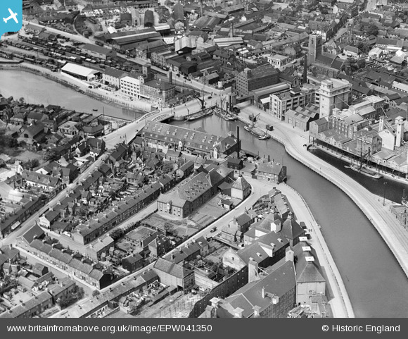
EPW041350 ENGLAND (1933). Stoke Bridge, Stoke Bridge Wharf and environs, Ipswich, 1933
© Copyright OpenStreetMap contributors and licensed by the OpenStreetMap Foundation. 2026. Cartography is licensed as CC BY-SA.
Nearby Images (8)
Details
| Title | [EPW041350] Stoke Bridge, Stoke Bridge Wharf and environs, Ipswich, 1933 |
| Reference | EPW041350 |
| Date | May-1933 |
| Link | |
| Place name | IPSWICH |
| Parish | |
| District | |
| Country | ENGLAND |
| Easting / Northing | 616413, 243924 |
| Longitude / Latitude | 1.1566620965815, 52.050957298315 |
| National Grid Reference | TM164439 |
Pins
Be the first to add a comment to this image!


![[EPW041350] Stoke Bridge, Stoke Bridge Wharf and environs, Ipswich, 1933](http://britainfromabove.org.uk/sites/all/libraries/aerofilms-images/public/100x100/EPW/041/EPW041350.jpg)
![[EPW041353] The New Cut at Stoke Bridge and environs, Ipswich, 1933](http://britainfromabove.org.uk/sites/all/libraries/aerofilms-images/public/100x100/EPW/041/EPW041353.jpg)
![[EPW041352] Stoke Bridge and environs, Ipswich, 1933](http://britainfromabove.org.uk/sites/all/libraries/aerofilms-images/public/100x100/EPW/041/EPW041352.jpg)
![[EPW041351] Stoke Bridge and environs, Ipswich, 1933](http://britainfromabove.org.uk/sites/all/libraries/aerofilms-images/public/100x100/EPW/041/EPW041351.jpg)
![[EAW053511] The town and docks, Ipswich, 1954](http://britainfromabove.org.uk/sites/all/libraries/aerofilms-images/public/100x100/EAW/053/EAW053511.jpg)
![[EPW058746] Stoke Bridge, St Peter's Church and environs, Ipswich, 1938](http://britainfromabove.org.uk/sites/all/libraries/aerofilms-images/public/100x100/EPW/058/EPW058746.jpg)
![[EPW058747] Wet Dock, New Cut and environs, Ipswich, 1938](http://britainfromabove.org.uk/sites/all/libraries/aerofilms-images/public/100x100/EPW/058/EPW058747.jpg)
![[EPW049173] Wet Dock and the town, Ipswich, 1935. This image has been produced from a copy-negative.](http://britainfromabove.org.uk/sites/all/libraries/aerofilms-images/public/100x100/EPW/049/EPW049173.jpg)