
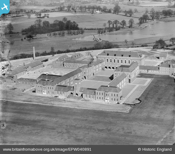
EPW040891 ENGLAND (1933). The Merchant Taylors' School, Moor Park, 1933
© Copyright OpenStreetMap contributors and licensed by the OpenStreetMap Foundation. 2026. Cartography is licensed as CC BY-SA.
Nearby Images (16)
EPW040891

EPW040890

EPW040892

EPW040893

EPW040899

EPW040888

EPR000494

EPW040895

EPW040896

EPW040889

EPR000496

EPR000495

EPW031466

EPW031285

EPW040897

EPW031471

Details
| Title | [EPW040891] The Merchant Taylors' School, Moor Park, 1933 |
| Reference | EPW040891 |
| Date | March-1933 |
| Link | |
| Place name | MOOR PARK |
| Parish | |
| District | |
| Country | ENGLAND |
| Easting / Northing | 509149, 194057 |
| Longitude / Latitude | -0.42270156631337, 51.634251094588 |
| National Grid Reference | TQ091941 |
Pins
Be the first to add a comment to this image!
User Comment Contributions
Beyond the newly-completed independent Merchant Taylors' School in the foreground is a dragline excavator, possibly steam driven, digging gravel from a "wet" pit, i.e. extracted from below the water table, thus creating Hampermill Lake. In 1932/33, approximately 12 million tons of gravel and sand were extracted in Britain, with about one-third coming from pits such as the one shown here. Further west of this location, new lakes appeared south-west of Rickmansworth when massive quantities of material were removed for the construction of Wembley Stadium and the 1924 British Empire Exhibition during the early 1920s, to form the popular Aquadrome. |

John Swain |
Monday 16th of September 2013 01:33:11 PM |