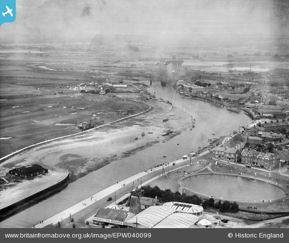
EPW040099 ENGLAND (1932). The Oyster Pond, River Arun and environs, Littlehampton, from the south-east, 1932
© Copyright OpenStreetMap contributors and licensed by the OpenStreetMap Foundation. 2026. Cartography is licensed as CC BY-SA.
Nearby Images (15)
Details
| Title | [EPW040099] The Oyster Pond, River Arun and environs, Littlehampton, from the south-east, 1932 |
| Reference | EPW040099 |
| Date | August-1932 |
| Link | |
| Place name | LITTLEHAMPTON |
| Parish | LITTLEHAMPTON |
| District | |
| Country | ENGLAND |
| Easting / Northing | 502783, 101460 |
| Longitude / Latitude | -0.54121676086715, 50.803006427227 |
| National Grid Reference | TQ028015 |
Pins
Be the first to add a comment to this image!


![[EPW040099] The Oyster Pond, River Arun and environs, Littlehampton, from the south-east, 1932](http://britainfromabove.org.uk/sites/all/libraries/aerofilms-images/public/100x100/EPW/040/EPW040099.jpg)
![[EAW022240] Butlins Park (Harbour Park) and the seafront, Littlehampton, from the west, 1949](http://britainfromabove.org.uk/sites/all/libraries/aerofilms-images/public/100x100/EAW/022/EAW022240.jpg)
![[EPW020175] Pond at Arun Terrace, Littlehampton, 1927](http://britainfromabove.org.uk/sites/all/libraries/aerofilms-images/public/100x100/EPW/020/EPW020175.jpg)
![[EPW043007] Butlin's Park and Arun Parade, Littlehampton, 1933](http://britainfromabove.org.uk/sites/all/libraries/aerofilms-images/public/100x100/EPW/043/EPW043007.jpg)
![[EPW011536] South Terrace and environs, Littlehampton, 1924](http://britainfromabove.org.uk/sites/all/libraries/aerofilms-images/public/100x100/EPW/011/EPW011536.jpg)
![[EAW012230] The mouth of the River Arun at Littlehampton Fort, the town and seafront, Littlehampton, from the west, 1947](http://britainfromabove.org.uk/sites/all/libraries/aerofilms-images/public/100x100/EAW/012/EAW012230.jpg)
![[EPW039467] East Pier, The Green and the seafront, Littlehampton, from the west, 1932](http://britainfromabove.org.uk/sites/all/libraries/aerofilms-images/public/100x100/EPW/039/EPW039467.jpg)
![[EPW039469] Littlehampton Fort, The Green and the seafront, Littlehampton, 1932](http://britainfromabove.org.uk/sites/all/libraries/aerofilms-images/public/100x100/EPW/039/EPW039469.jpg)
![[EPW017750] The seafront and pier, Littlehampton, 1927](http://britainfromabove.org.uk/sites/all/libraries/aerofilms-images/public/100x100/EPW/017/EPW017750.jpg)
![[EPW000530] Littlehampton, from the south-east, 1920](http://britainfromabove.org.uk/sites/all/libraries/aerofilms-images/public/100x100/EPW/000/EPW000530.jpg)
![[EAW012226] The Beach Hotel, Pavilion-on-the-Green and The Promenade, Littlehampton, from the west, 1947. This image was marked by Aerofilms Ltd for photo editing.](http://britainfromabove.org.uk/sites/all/libraries/aerofilms-images/public/100x100/EAW/012/EAW012226.jpg)
![[EAW022237] The mouth of the River Arun and the seafront, Littlehampton, from the south-east, 1949](http://britainfromabove.org.uk/sites/all/libraries/aerofilms-images/public/100x100/EAW/022/EAW022237.jpg)
![[EPW001486] General view of the town and The Green, Littlehampton, 1920](http://britainfromabove.org.uk/sites/all/libraries/aerofilms-images/public/100x100/EPW/001/EPW001486.jpg)
![[EAW022239] East Pier, Butlins Park (Harbour Park) and the seafront, Littlehampton, from the south-east, 1949](http://britainfromabove.org.uk/sites/all/libraries/aerofilms-images/public/100x100/EAW/022/EAW022239.jpg)
![[EAW022238] Littlehampton Golf Course, the River Arun and the town, Littlehampton, 1949](http://britainfromabove.org.uk/sites/all/libraries/aerofilms-images/public/100x100/EAW/022/EAW022238.jpg)