
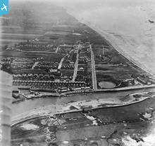
EPW001486 ENGLAND (1920). General view of the town and The Green, Littlehampton, 1920

© Copyright OpenStreetMap contributors and licensed by the OpenStreetMap Foundation. 2026. Cartography is licensed as CC BY-SA.
Nearby Images (8)
EPW001486

EAW022241
, the seafront and the town, Littlehampton, 1949")
EPW020175

EPW011536

EAW012226

EPW000530

EPW040099

EAW012223

Details
| Title | [EPW001486] General view of the town and The Green, Littlehampton, 1920 |
| Reference | EPW001486 |
| Date | June-1920 |
| Link | |
| Place name | LITTLEHAMPTON |
| Parish | LITTLEHAMPTON |
| District | |
| Country | ENGLAND |
| Easting / Northing | 502964, 101635 |
| Longitude / Latitude | -0.53859965740647, 50.804547646936 |
| National Grid Reference | TQ030016 |
Pins

MB |
Friday 5th of October 2012 03:42:37 PM | |
|
MB |
Friday 5th of October 2012 03:42:14 PM | |
|
MB |
Friday 5th of October 2012 03:41:36 PM | |
|
MB |
Friday 5th of October 2012 03:39:42 PM | |
|
MB |
Friday 5th of October 2012 03:38:50 PM | |
|
MB |
Friday 5th of October 2012 03:38:27 PM | |
|
MB |
Friday 5th of October 2012 03:37:18 PM | |
|
MB |
Friday 5th of October 2012 03:36:29 PM | |
|
MB |
Friday 5th of October 2012 03:34:21 PM | |
|
MB |
Friday 5th of October 2012 03:33:55 PM | |
|
MB |
Friday 5th of October 2012 03:33:24 PM | |
|
MB |
Friday 5th of October 2012 03:32:59 PM | |
|
MB |
Friday 5th of October 2012 03:31:59 PM | |
|
MB |
Friday 5th of October 2012 03:30:57 PM |
User Comment Contributions
Littlehampton can claim to be the fifth course in Sussex, opened in 1889 and it also had an unusual, if not unique feature. The only direct route from Littlehampton Town to the Club Room and first tee was by ferry across the River Arun. This remained the sole access route until Henry, 15th Duke of Norfolk, opened the Swing Bridge on 7th August 1908. During 1893 it was decided to turn the 9 hole course into 18 holes, which were subsequently lengthened and the bunkering tightened up by Messrs Hawtree and JH Taylor Ltd. |
royalfixit |
Thursday 7th of August 2014 05:43:49 PM |