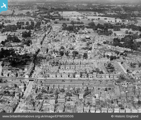
EPW039506 ENGLAND (1932). East Street and the town centre, Horsham, 1932
    © Copyright OpenStreetMap contributors and licensed by the OpenStreetMap Foundation. 2025. Cartography is licensed as CC BY-SA.
  
Nearby Images (13)
Details
| Title | [EPW039506] East Street and the town centre, Horsham, 1932 | 
| Reference | EPW039506 | 
| Date | August-1932 | 
| Link | |
| Place name | HORSHAM | 
| Parish | |
| District | |
| Country | ENGLAND | 
| Easting / Northing | 517382, 130572 | 
| Longitude / Latitude | -0.32472561595535, 51.061936208098 | 
| National Grid Reference | TQ174306 | 
Pins
|  Denne Road Gospel Hall |   Dan Gregory | Monday 2nd of June 2014 09:04:42 PM | 
|  Congregational Church. Gothic Revival chapel dating from 1884, replaced by a modern United Reformed Church in 1983. |   Dan Gregory | Monday 2nd of June 2014 09:03:50 PM | 
|  The Manor House. Large house to a design of 1704 by Nathaniel Tredgold. The building has been used as a school and as offices for the RSPCA but is now divided into private apartments. |   Dan Gregory | Monday 2nd of June 2014 08:30:45 PM | 
|  Roman Catholic Church of St. John the Evangelist. Sandstone rubble building in perpendicular style by E. and J. Goldie, 1919–23. |   Dan Gregory | Monday 2nd of June 2014 08:09:03 PM | 
|  King and Barnes Brewery |   Dan Gregory | Monday 2nd of June 2014 08:07:57 PM | 
|  Horsham Urban District Council Depot. Electricity generating station, maintenance workshops and refuse destructor built c.1902 |   Dan Gregory | Monday 2nd of June 2014 08:06:50 PM | 
|  Jireh Baptist Chapel, built 1857. In 2008 the then redundant building was converted to become the Madina Mosque. |   Dan Gregory | Monday 2nd of June 2014 08:04:25 PM | 
|  The Iron Bridge in East Street. |   Dan Gregory | Monday 2nd of June 2014 07:59:34 PM | 
|  The Capitol Theatre. Not to be confused with the current Capitol, which was formerly the Ritz Cinema, Later the ABC and then Horsham Arts Centre. |   Dan Gregory | Monday 2nd of June 2014 07:57:30 PM | 
|  Horsham Gas Works, demolished c. 1970 |   Dan Gregory | Monday 2nd of June 2014 07:52:54 PM | 
|   Alan McFaden | Thursday 25th of April 2013 05:06:35 PM | |
|  The Carfax area |   Biggles1951 | Friday 14th of December 2012 11:25:44 AM | 
|  Demolished in the 1990s (leaving only the Spire) to make way for the building of a large office complex (complete with road underpass) for Sun Alliance Insurance. Many of the surrounding houses were also levelled. |   Biggles1951 | Friday 14th of December 2012 11:23:04 AM | 
 
             
  ![[EPW039506] East Street and the town centre, Horsham, 1932](http://britainfromabove.org.uk/sites/all/libraries/aerofilms-images/public/100x100/EPW/039/EPW039506.jpg) 
  
                                          ![[EAW028787] The town, Horsham, 1950](http://britainfromabove.org.uk/sites/all/libraries/aerofilms-images/public/100x100/EAW/028/EAW028787.jpg) 
 ![[EPW039507] Horsham Park and the town centre, Horsham, 1932](http://britainfromabove.org.uk/sites/all/libraries/aerofilms-images/public/100x100/EPW/039/EPW039507.jpg) 
 ![[EAW028785] Horsham Park and the town centre, Horsham, 1950](http://britainfromabove.org.uk/sites/all/libraries/aerofilms-images/public/100x100/EAW/028/EAW028785.jpg) 
 ![[EPW024719] The town centre, Horsham, 1928. This image has been produced from a damaged negative.](http://britainfromabove.org.uk/sites/all/libraries/aerofilms-images/public/100x100/EPW/024/EPW024719.jpg) 
 ![[EAW039310] Horsham Park and the town, Horsham, from the south, 1951. This image has been produced from a damaged print.](http://britainfromabove.org.uk/sites/all/libraries/aerofilms-images/public/100x100/EAW/039/EAW039310.jpg) 
 ![[EPW024717] The town centre, Horsham, 1928. This image has been produced from a damaged negative.](http://britainfromabove.org.uk/sites/all/libraries/aerofilms-images/public/100x100/EPW/024/EPW024717.jpg) 
 ![[EAW028786] The town centre, Horsham, 1950](http://britainfromabove.org.uk/sites/all/libraries/aerofilms-images/public/100x100/EAW/028/EAW028786.jpg) 
 ![[EAW037050] The town centre, Horsham, 1951. This image has been produced from a print.](http://britainfromabove.org.uk/sites/all/libraries/aerofilms-images/public/100x100/EAW/037/EAW037050.jpg) 
 ![[EPW039510] Horsham Park, North Street and the town, Horsham, 1932](http://britainfromabove.org.uk/sites/all/libraries/aerofilms-images/public/100x100/EPW/039/EPW039510.jpg) 
 ![[EAW037049] The town, Horsham, 1951. This image has been produced from a print.](http://britainfromabove.org.uk/sites/all/libraries/aerofilms-images/public/100x100/EAW/037/EAW037049.jpg) 
 ![[EAW039309] The town, Horsham, 1951. This image has been produced from a print marked by Aerofilms Ltd for photo editing.](http://britainfromabove.org.uk/sites/all/libraries/aerofilms-images/public/100x100/EAW/039/EAW039309.jpg) 
 ![[EPW039508] The Horsham gasometer, London Road and the town centre, Horsham, 1932](http://britainfromabove.org.uk/sites/all/libraries/aerofilms-images/public/100x100/EPW/039/EPW039508.jpg) 
 