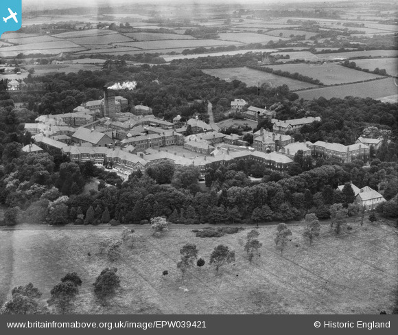
EPW039421 ENGLAND (1932). Hellingly Hospital and surrounding countryside, Hellingly, 1932
© Copyright OpenStreetMap contributors and licensed by the OpenStreetMap Foundation. 2026. Cartography is licensed as CC BY-SA.
Nearby Images (5)
Details
| Title | [EPW039421] Hellingly Hospital and surrounding countryside, Hellingly, 1932 |
| Reference | EPW039421 |
| Date | August-1932 |
| Link | |
| Place name | HELLINGLY |
| Parish | HELLINGLY |
| District | |
| Country | ENGLAND |
| Easting / Northing | 559756, 112357 |
| Longitude / Latitude | 0.27158872331912, 50.888024823914 |
| National Grid Reference | TQ598124 |
Pins

Dan Gregory |
Wednesday 4th of June 2014 03:49:28 PM | |

Dan Gregory |
Wednesday 4th of June 2014 03:48:59 PM | |

Dan Gregory |
Wednesday 4th of June 2014 03:29:27 PM | |

Dan Gregory |
Wednesday 4th of June 2014 03:26:35 PM | |

Dan Gregory |
Wednesday 4th of June 2014 03:26:01 PM | |

Dan Gregory |
Wednesday 4th of June 2014 03:24:57 PM | |

Dan Gregory |
Wednesday 4th of June 2014 03:24:33 PM | |

Dan Gregory |
Wednesday 4th of June 2014 03:24:04 PM | |

Dan Gregory |
Wednesday 4th of June 2014 03:22:11 PM | |

Dan Gregory |
Wednesday 4th of June 2014 03:21:17 PM | |

Dan Gregory |
Wednesday 4th of June 2014 03:20:05 PM | |

Dan Gregory |
Wednesday 4th of June 2014 03:10:42 PM |
User Comment Contributions

Dan Gregory |
Wednesday 4th of June 2014 03:50:22 PM |


![[EPW039421] Hellingly Hospital and surrounding countryside, Hellingly, 1932](http://britainfromabove.org.uk/sites/all/libraries/aerofilms-images/public/100x100/EPW/039/EPW039421.jpg)
![[EPW039420] Hellingly Hospital and surrounding countryside, Hellingly, 1932](http://britainfromabove.org.uk/sites/all/libraries/aerofilms-images/public/100x100/EPW/039/EPW039420.jpg)
![[EPW039422] Hellingly Hospital and surrounding countryside, Hellingly, 1932](http://britainfromabove.org.uk/sites/all/libraries/aerofilms-images/public/100x100/EPW/039/EPW039422.jpg)
![[EPW039426] Hellingly Hospital Homestead and Church, Hellingly, 1932](http://britainfromabove.org.uk/sites/all/libraries/aerofilms-images/public/100x100/EPW/039/EPW039426.jpg)
![[EPW039425] Hellingly Hospital Homestead and Church, Hellingly, 1932. This image has been affected by flare.](http://britainfromabove.org.uk/sites/all/libraries/aerofilms-images/public/100x100/EPW/039/EPW039425.jpg)
