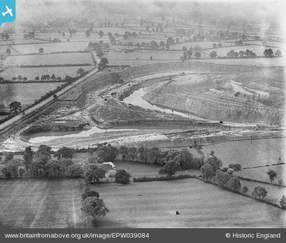
EPW039084 ENGLAND (1932). Spiers's Farm and quarry belonging to the Southam Cement Works, Stockton, 1932
© Copyright OpenStreetMap contributors and licensed by the OpenStreetMap Foundation. 2026. Cartography is licensed as CC BY-SA.
Details
| Title | [EPW039084] Spiers's Farm and quarry belonging to the Southam Cement Works, Stockton, 1932 |
| Reference | EPW039084 |
| Date | July-1932 |
| Link | |
| Place name | STOCKTON |
| Parish | STOCKTON |
| District | |
| Country | ENGLAND |
| Easting / Northing | 442314, 263549 |
| Longitude / Latitude | -1.3798585619113, 52.268075069843 |
| National Grid Reference | SP423635 |
Pins
Be the first to add a comment to this image!


![[EPW039084] Spiers's Farm and quarry belonging to the Southam Cement Works, Stockton, 1932](http://britainfromabove.org.uk/sites/all/libraries/aerofilms-images/public/100x100/EPW/039/EPW039084.jpg)
![[EPW039079] Quarry belonging to the Southam Cement Works, Stockton, from the south-east, 1932](http://britainfromabove.org.uk/sites/all/libraries/aerofilms-images/public/100x100/EPW/039/EPW039079.jpg)
![[EPW039087] Spiers's Farm and quarry belonging to the Southam Cement Works, Stockton, from the south-east, 1932](http://britainfromabove.org.uk/sites/all/libraries/aerofilms-images/public/100x100/EPW/039/EPW039087.jpg)
![[EPW039088] Quarry belonging to the Southam Cement Works, Stockton, from the south-east, 1932](http://britainfromabove.org.uk/sites/all/libraries/aerofilms-images/public/100x100/EPW/039/EPW039088.jpg)