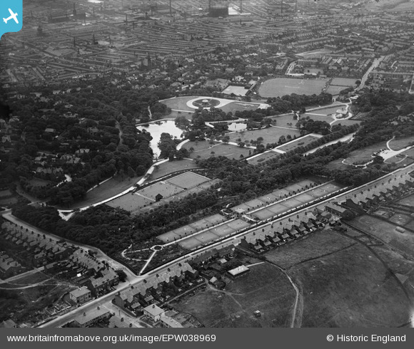
EPW038969 ENGLAND (1932). Corporation Park and environs, Blackburn, 1932
    © Copyright OpenStreetMap contributors and licensed by the OpenStreetMap Foundation. 2025. Cartography is licensed as CC BY-SA.
  
Details
| Title | [EPW038969] Corporation Park and environs, Blackburn, 1932 | 
| Reference | EPW038969 | 
| Date | July-1932 | 
| Link | |
| Place name | BLACKBURN | 
| Parish | |
| District | |
| Country | ENGLAND | 
| Easting / Northing | 367477, 429049 | 
| Longitude / Latitude | -2.4933350156782, 53.756566182442 | 
| National Grid Reference | SD675290 | 
Pins
|  Alexandra Meadows Cricket ground |   ewoodeddie1968 | Monday 26th of September 2022 06:33:35 PM | 
|  Brantfell Road the "sixty-steps" |   ewoodeddie1968 | Monday 26th of September 2022 06:31:23 PM | 
 
             
  ![[EPW038969] Corporation Park and environs, Blackburn, 1932](http://britainfromabove.org.uk/sites/all/libraries/aerofilms-images/public/100x100/EPW/038/EPW038969.jpg) 
  
                                          ![[EPW038971] Corporation Park and environs, Blackburn, 1932](http://britainfromabove.org.uk/sites/all/libraries/aerofilms-images/public/100x100/EPW/038/EPW038971.jpg) 
 ![[EPW038970] Corporation Park and environs, Blackburn, 1932](http://britainfromabove.org.uk/sites/all/libraries/aerofilms-images/public/100x100/EPW/038/EPW038970.jpg) 
 ![[EPW038968] Corporation Park, Alexandra Meadows Cricket Ground and environs, Blackburn, 1932](http://britainfromabove.org.uk/sites/all/libraries/aerofilms-images/public/100x100/EPW/038/EPW038968.jpg)