
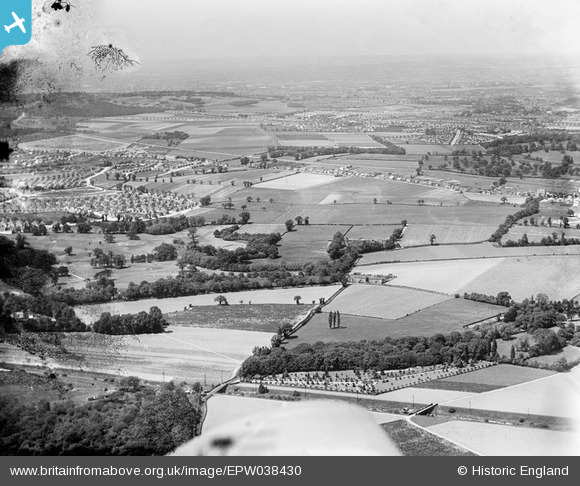
EPW038430 ENGLAND (1932). New housing site near Blackfen and Lamorbey Park Golf Course, Bexley, from the south-east, 1932
© Copyright OpenStreetMap contributors and licensed by the OpenStreetMap Foundation. 2026. Cartography is licensed as CC BY-SA.
Nearby Images (5)
EPW038430

EPW044385

EPW044387

EPW044383

EPW044731

Details
| Title | [EPW038430] New housing site near Blackfen and Lamorbey Park Golf Course, Bexley, from the south-east, 1932 |
| Reference | EPW038430 |
| Date | 14-June-1932 |
| Link | |
| Place name | BEXLEY |
| Parish | |
| District | |
| Country | ENGLAND |
| Easting / Northing | 547414, 173004 |
| Longitude / Latitude | 0.12108885249603, 51.43633712347 |
| National Grid Reference | TQ474730 |
Pins

Barney |
Monday 21st of May 2018 07:00:05 AM | |
|
Barney |
Saturday 19th of August 2017 11:56:43 AM | |
|
Barney |
Saturday 19th of August 2017 11:55:54 AM | |
|
Barney |
Saturday 19th of August 2017 11:47:09 AM | |

Stephen Challis |
Friday 13th of February 2015 09:41:12 PM | |
|
Stephen Challis |
Friday 13th of February 2015 09:40:04 PM | |
|
Stephen Challis |
Friday 13th of February 2015 09:38:46 PM | |
|
Stephen Challis |
Friday 13th of February 2015 09:38:16 PM | |
|
Stephen Challis |
Friday 13th of February 2015 09:37:24 PM | |
|
Stephen Challis |
Friday 13th of February 2015 09:36:57 PM | |
|
Stephen Challis |
Friday 13th of February 2015 09:36:40 PM | |
|
Stephen Challis |
Friday 13th of February 2015 09:36:11 PM |