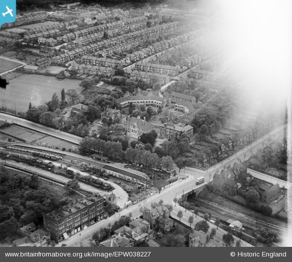
EPW038227 ENGLAND (1932). Woodside Hospital and Cranley Gardens Railway Station, Muswell Hill, 1932. This image has been affected by flare.
    © Copyright OpenStreetMap contributors and licensed by the OpenStreetMap Foundation. 2025. Cartography is licensed as CC BY-SA.
  
Nearby Images (15)
Details
| Title | [EPW038227] Woodside Hospital and Cranley Gardens Railway Station, Muswell Hill, 1932. This image has been affected by flare. | 
| Reference | EPW038227 | 
| Date | June-1932 | 
| Link | |
| Place name | MUSWELL HILL | 
| Parish | |
| District | |
| Country | ENGLAND | 
| Easting / Northing | 528380, 189221 | 
| Longitude / Latitude | -0.1467131644321, 51.586726343813 | 
| National Grid Reference | TQ284892 | 
Pins
Be the first to add a comment to this image!
 
             
  ![[EPW038227] Woodside Hospital and Cranley Gardens Railway Station, Muswell Hill, 1932. This image has been affected by flare.](http://britainfromabove.org.uk/sites/all/libraries/aerofilms-images/public/100x100/EPW/038/EPW038227.jpg) 
  
                                          ![[EPW038225] Woodside Hospital and Cranley Gardens Railway Station, Muswell Hill, 1932](http://britainfromabove.org.uk/sites/all/libraries/aerofilms-images/public/100x100/EPW/038/EPW038225.jpg) 
 ![[EPW038224] Woodside Hospital and environs, Muswell Hill, 1932](http://britainfromabove.org.uk/sites/all/libraries/aerofilms-images/public/100x100/EPW/038/EPW038224.jpg) 
 ![[EPW038226] Woodside Hospital and environs, Muswell Hill, 1932. This image was marked by Aerofilms Ltd for photo editing.](http://britainfromabove.org.uk/sites/all/libraries/aerofilms-images/public/100x100/EPW/038/EPW038226.jpg) 
 ![[EPW038228] Woodside Hospital and Cranley Gardens Railway Station, Muswell Hill, 1932](http://britainfromabove.org.uk/sites/all/libraries/aerofilms-images/public/100x100/EPW/038/EPW038228.jpg) 
 ![[EPW038223] Woodside Hospital and environs, Muswell Hill, 1932](http://britainfromabove.org.uk/sites/all/libraries/aerofilms-images/public/100x100/EPW/038/EPW038223.jpg) 
 ![[EPW038229] Woodside Hospital and environs, Muswell Hill, 1932](http://britainfromabove.org.uk/sites/all/libraries/aerofilms-images/public/100x100/EPW/038/EPW038229.jpg) 
 ![[EPW009664] The area of Highgate Wood, Highgate, from the north, 1923](http://britainfromabove.org.uk/sites/all/libraries/aerofilms-images/public/100x100/EPW/009/EPW009664.jpg) 
 ![[EPW048335] St James's Church and the surrounding residential area, Muswell Hill, 1935](http://britainfromabove.org.uk/sites/all/libraries/aerofilms-images/public/100x100/EPW/048/EPW048335.jpg) 
 ![[EPW048338] St James's Church and the surrounding residential area, Muswell Hill, 1935](http://britainfromabove.org.uk/sites/all/libraries/aerofilms-images/public/100x100/EPW/048/EPW048338.jpg) 
 ![[EPW048329] St James's Church and the surrounding residential area, Muswell Hill, 1935](http://britainfromabove.org.uk/sites/all/libraries/aerofilms-images/public/100x100/EPW/048/EPW048329.jpg) 
 ![[EPW048340] St James's Church and the surrounding residential area, Muswell Hill, 1935](http://britainfromabove.org.uk/sites/all/libraries/aerofilms-images/public/100x100/EPW/048/EPW048340.jpg) 
 ![[EPW048332] St James's Church and the surrounding residential area, Muswell Hill, 1935](http://britainfromabove.org.uk/sites/all/libraries/aerofilms-images/public/100x100/EPW/048/EPW048332.jpg) 
 ![[EPW048339] St James's Church and the surrounding residential area, Muswell Hill, 1935](http://britainfromabove.org.uk/sites/all/libraries/aerofilms-images/public/100x100/EPW/048/EPW048339.jpg) 
 ![[EPW048333] St James's Church and the surrounding residential area, Muswell Hill, 1935](http://britainfromabove.org.uk/sites/all/libraries/aerofilms-images/public/100x100/EPW/048/EPW048333.jpg)