
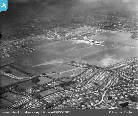
EPW037824 ENGLAND (1932). Croydon Airport, South Beddington, 1932
© Copyright OpenStreetMap contributors and licensed by the OpenStreetMap Foundation. 2026. Cartography is licensed as CC BY-SA.
Nearby Images (3)
EPW037824

EPW037821

EPW006249

Details
| Title | [EPW037824] Croydon Airport, South Beddington, 1932 |
| Reference | EPW037824 |
| Date | May-1932 |
| Link | |
| Place name | SOUTH BEDDINGTON |
| Parish | |
| District | |
| Country | ENGLAND |
| Easting / Northing | 530544, 163038 |
| Longitude / Latitude | -0.12516479834075, 51.350903826729 |
| National Grid Reference | TQ305630 |
Pins

James Cullen |
Monday 9th of January 2023 05:04:36 PM | |
|
Aquarias |
Sunday 29th of September 2013 03:01:22 AM | |
|
Aquarias |
Saturday 28th of September 2013 03:06:05 AM | |
|
Aquarias |
Saturday 28th of September 2013 03:03:20 AM | |
|
Falcon |
Friday 3rd of May 2013 01:35:33 PM | |
|
Falcon |
Friday 3rd of May 2013 01:34:56 PM | |
Definately Foresters Drive, I walked this road every day to school from Plough Lane. |
Aquarias |
Saturday 28th of September 2013 03:00:46 AM |
User Comment Contributions
Does anyone know what the white circle in the centre might be? |
Flyboy |
Sunday 17th of July 2016 11:10:00 AM |
I beleive the circle indicated that it was a 'Licenced Public Aerodrome - All Types' see http://www.airwaysmuseum.com/Aerodrome%20ground%20markings%2028.htm. Visual markings were used before VHF radio was installed on aircraft and is used by some gliding sites still. |
JohnM |
Sunday 17th of July 2016 11:10:00 AM |