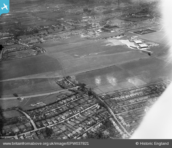
EPW037821 ENGLAND (1932). Croydon Airport, South Beddington, 1932
© Copyright OpenStreetMap contributors and licensed by the OpenStreetMap Foundation. 2026. Cartography is licensed as CC BY-SA.
Details
| Title | [EPW037821] Croydon Airport, South Beddington, 1932 |
| Reference | EPW037821 |
| Date | May-1932 |
| Link | |
| Place name | SOUTH BEDDINGTON |
| Parish | |
| District | |
| Country | ENGLAND |
| Easting / Northing | 530627, 162949 |
| Longitude / Latitude | -0.12400613996934, 51.350084825389 |
| National Grid Reference | TQ306629 |
Pins

Aquarias |
Monday 30th of September 2013 03:44:11 AM | |

Aquarias |
Monday 30th of September 2013 03:42:36 AM | |

Aquarias |
Monday 30th of September 2013 03:39:47 AM | |

Aquarias |
Monday 30th of September 2013 03:38:26 AM | |

Aquarias |
Sunday 29th of September 2013 02:54:43 AM | |

Falcon |
Tuesday 7th of May 2013 08:18:54 PM | |

Falcon |
Tuesday 7th of May 2013 08:17:23 PM | |

Falcon |
Friday 3rd of May 2013 01:33:45 PM | |

Falcon |
Friday 3rd of May 2013 01:33:09 PM |


![[EPW037821] Croydon Airport, South Beddington, 1932](http://britainfromabove.org.uk/sites/all/libraries/aerofilms-images/public/100x100/EPW/037/EPW037821.jpg)
![[EPW037824] Croydon Airport, South Beddington, 1932](http://britainfromabove.org.uk/sites/all/libraries/aerofilms-images/public/100x100/EPW/037/EPW037824.jpg)
![[EPW018120] Croydon Aerodrome, South Beddington, 1927. This image has been produced from a copy-negative.](http://britainfromabove.org.uk/sites/all/libraries/aerofilms-images/public/100x100/EPW/018/EPW018120.jpg)