
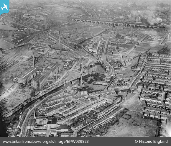
EPW036823 ENGLAND (1931). Brinksway and the Stockport Viaduct, Stockport, 1931
© Copyright OpenStreetMap contributors and licensed by the OpenStreetMap Foundation. 2026. Cartography is licensed as CC BY-SA.
Nearby Images (2)
EPW036823

EAW018252

Details
| Title | [EPW036823] Brinksway and the Stockport Viaduct, Stockport, 1931 |
| Reference | EPW036823 |
| Date | September-1931 |
| Link | |
| Place name | STOCKPORT |
| Parish | |
| District | |
| Country | ENGLAND |
| Easting / Northing | 388366, 390008 |
| Longitude / Latitude | -2.1750212647657, 53.406500291446 |
| National Grid Reference | SJ884900 |
Pins

Sk5area |
Friday 1st of November 2024 08:51:16 PM | |
|
Sk5area |
Friday 1st of November 2024 08:50:22 PM | |
|
Sk5area |
Friday 1st of November 2024 08:49:40 PM | |
|
Sk5area |
Friday 1st of November 2024 08:48:13 PM | |
|
Sk5area |
Friday 1st of November 2024 08:42:20 PM | |
|
Sk5area |
Friday 1st of November 2024 08:41:31 PM | |
|
Sk5area |
Friday 1st of November 2024 08:40:55 PM | |
|
Sk5area |
Friday 1st of November 2024 08:40:13 PM | |
|
Sk5area |
Friday 1st of November 2024 08:39:19 PM | |
|
Sk5area |
Friday 1st of November 2024 08:35:06 PM | |
|
Sk5area |
Friday 1st of November 2024 08:32:32 PM | |
|
Sk5area |
Friday 1st of November 2024 08:31:44 PM | |
|
Sk5area |
Friday 1st of November 2024 08:30:58 PM | |
|
Sk5area |
Friday 1st of November 2024 08:30:22 PM | |
|
Sk5area |
Friday 1st of November 2024 08:27:27 PM | |
|
Sk5area |
Friday 1st of November 2024 08:26:40 PM | |
|
Sk5area |
Friday 1st of November 2024 08:25:54 PM | |
|
Sk5area |
Friday 1st of November 2024 08:25:12 PM | |
|
Sk5area |
Friday 1st of November 2024 08:19:06 PM | |
|
Sk5area |
Friday 1st of November 2024 08:17:49 PM | |
|
Sk5area |
Friday 1st of November 2024 08:16:22 PM | |
|
Neilb |
Wednesday 27th of March 2024 11:57:38 AM | |
|
Neilb |
Wednesday 27th of March 2024 11:56:38 AM | |
|
Pookie |
Thursday 18th of April 2019 09:39:51 PM | |
|
John Ellis |
Sunday 6th of January 2013 12:06:00 PM | |
|
John Ellis |
Sunday 6th of January 2013 12:05:03 PM | |
|
John Ellis |
Saturday 29th of December 2012 04:24:12 PM | |
|
John Ellis |
Saturday 29th of December 2012 04:23:34 PM | |
|
John Ellis |
Saturday 29th of December 2012 04:22:34 PM | |
|
totoro |
Wednesday 19th of December 2012 02:09:56 PM | |
|
John Ellis |
Friday 14th of December 2012 09:27:01 PM | |
|
John Ellis |
Friday 14th of December 2012 09:25:43 PM | |
|
John Ellis |
Friday 14th of December 2012 09:24:06 PM | |
|
John Ellis |
Friday 14th of December 2012 09:22:20 PM | |
|
John Ellis |
Friday 14th of December 2012 09:21:20 PM | |
|
John Ellis |
Friday 14th of December 2012 09:18:49 PM | |
|
John Ellis |
Friday 14th of December 2012 09:10:50 PM | |
|
John Ellis |
Friday 14th of December 2012 09:09:46 PM | |
|
John Ellis |
Friday 14th of December 2012 09:08:52 PM | |
|
John Ellis |
Friday 14th of December 2012 09:03:46 PM | |
|
John Ellis |
Friday 14th of December 2012 09:01:34 PM | |
|
John Ellis |
Friday 14th of December 2012 08:57:41 PM | |
|
John Ellis |
Friday 14th of December 2012 08:52:04 PM | |
|
John Ellis |
Friday 14th of December 2012 08:51:17 PM | |
|
John Ellis |
Friday 14th of December 2012 08:49:50 PM | |
|
John Ellis |
Friday 14th of December 2012 08:48:09 PM | |
|
John Ellis |
Friday 14th of December 2012 08:46:42 PM | |
|
John Ellis |
Friday 14th of December 2012 08:45:46 PM | |
|
John Ellis |
Friday 14th of December 2012 08:43:18 PM | |
|
John Ellis |
Friday 14th of December 2012 08:42:28 PM | |
|
John Ellis |
Friday 14th of December 2012 08:40:05 PM | |
|
John Ellis |
Friday 14th of December 2012 08:38:55 PM | |
|
John Ellis |
Friday 14th of December 2012 08:38:08 PM | |
|
John Ellis |
Friday 14th of December 2012 08:36:10 PM | |
|
John Ellis |
Friday 14th of December 2012 08:34:13 PM | |
|
John Ellis |
Friday 14th of December 2012 08:33:24 PM |


User Comment Contributions
View looking east. |

Class31 |
Monday 17th of June 2013 07:24:41 AM |