
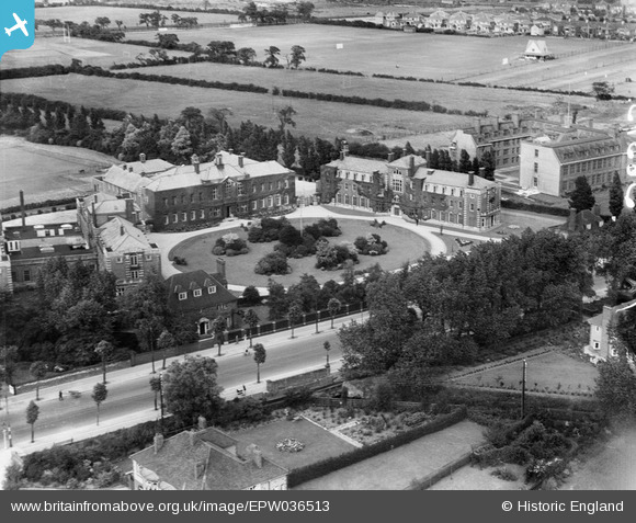
EPW036513 ENGLAND (1931). The University of Hull, Kingston upon Hull, 1931
© Copyright OpenStreetMap contributors and licensed by the OpenStreetMap Foundation. 2025. Cartography is licensed as CC BY-SA.
Nearby Images (7)
EPW036513

EPW036400

EPW036403

EPW036541

EPW036402

EPW036401

EPW036399

Details
| Title | [EPW036513] The University of Hull, Kingston upon Hull, 1931 |
| Reference | EPW036513 |
| Date | August-1931 |
| Link | |
| Place name | KINGSTON UPON HULL |
| Parish | |
| District | |
| Country | ENGLAND |
| Easting / Northing | 507514, 431601 |
| Longitude / Latitude | -0.36858278809813, 53.769421343597 |
| National Grid Reference | TA075316 |
Pins

CartoonHead |
Sunday 27th of December 2015 03:34:28 PM | |
|
John Wass |
Friday 28th of November 2014 11:28:29 AM |
User Comment Contributions
The buildings circling the lawn were a teacher training college with the university on the right but are now absorbed into Hull University. I trained there for my Cert Ed '75 - '78 the minimum entry requirement was 4 O-levels. Happy days! |
Philip |
Friday 31st of October 2014 09:09:16 PM |