
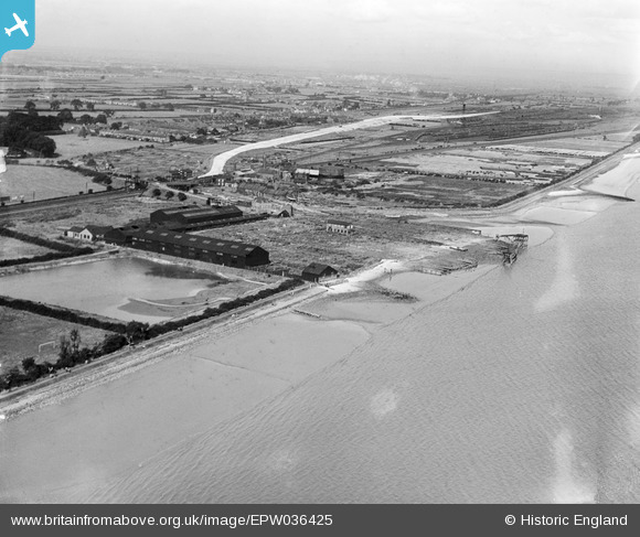
EPW036425 ENGLAND (1931). The Hessle Haven and environs, Hessle, from the south-west, 1931
© Copyright OpenStreetMap contributors and licensed by the OpenStreetMap Foundation. 2026. Cartography is licensed as CC BY-SA.
Nearby Images (2)
EPW036425

EPW036429

Details
| Title | [EPW036425] The Hessle Haven and environs, Hessle, from the south-west, 1931 |
| Reference | EPW036425 |
| Date | August-1931 |
| Link | |
| Place name | HESSLE |
| Parish | HESSLE |
| District | |
| Country | ENGLAND |
| Easting / Northing | 503219, 425442 |
| Longitude / Latitude | -0.43578484080969, 53.71494711399 |
| National Grid Reference | TA032254 |
Pins

SPRINGHEAD |
Friday 9th of August 2019 12:44:01 AM | |
|
CartoonHead |
Saturday 1st of August 2015 06:29:05 PM | |
|
John Wass |
Saturday 21st of June 2014 09:32:12 PM | |
|
John Wass |
Saturday 21st of June 2014 09:20:37 PM |
User Comment Contributions
Please note the church on the tree line. |
John Wass |
Sunday 23rd of October 2016 04:37:53 PM |
The Church is St Nicholas Church on Pickering Road. |
CartoonHead |
Sunday 23rd of October 2016 04:37:53 PM |