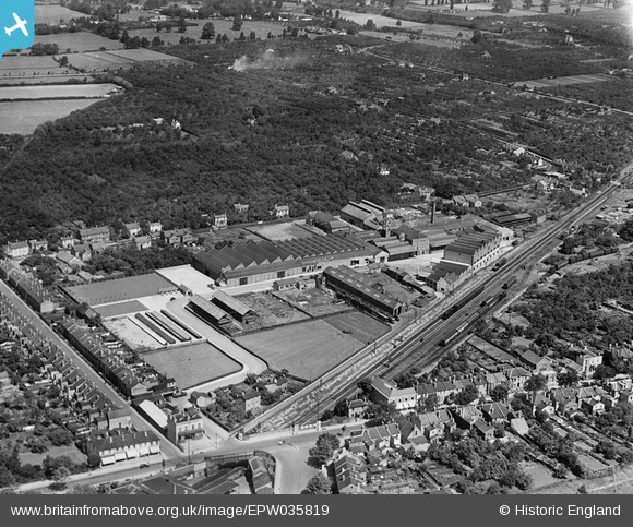
EPW035819 ENGLAND (1931). The Sunningend Engineering Works and environs, Cheltenham, 1931
© Copyright OpenStreetMap contributors and licensed by the OpenStreetMap Foundation. 2026. Cartography is licensed as CC BY-SA.
Nearby Images (16)
Details
| Title | [EPW035819] The Sunningend Engineering Works and environs, Cheltenham, 1931 |
| Reference | EPW035819 |
| Date | July-1931 |
| Link | |
| Place name | CHELTENHAM |
| Parish | |
| District | |
| Country | ENGLAND |
| Easting / Northing | 393222, 222415 |
| Longitude / Latitude | -2.098521603935, 51.899801329961 |
| National Grid Reference | SO932224 |
Pins

John W |
Monday 22nd of August 2016 11:40:06 PM |


![[EPW035819] The Sunningend Engineering Works and environs, Cheltenham, 1931](http://britainfromabove.org.uk/sites/all/libraries/aerofilms-images/public/100x100/EPW/035/EPW035819.jpg)
![[EPW024141] The Sunningend Engineering Works, Cheltenham, 1928](http://britainfromabove.org.uk/sites/all/libraries/aerofilms-images/public/100x100/EPW/024/EPW024141.jpg)
![[EPW035824] The Sunningend Engineering Works and environs, Cheltenham, 1931](http://britainfromabove.org.uk/sites/all/libraries/aerofilms-images/public/100x100/EPW/035/EPW035824.jpg)
![[EPW035822] The Sunningend Engineering Works and environs, Cheltenham, 1931](http://britainfromabove.org.uk/sites/all/libraries/aerofilms-images/public/100x100/EPW/035/EPW035822.jpg)
![[EPW014495] The Sunningend Engineering Works, Cheltenham, 1925. This image has been produced from a print.](http://britainfromabove.org.uk/sites/all/libraries/aerofilms-images/public/100x100/EPW/014/EPW014495.jpg)
![[EPW035818] The Sunningend Engineering Works and environs, Cheltenham, 1931](http://britainfromabove.org.uk/sites/all/libraries/aerofilms-images/public/100x100/EPW/035/EPW035818.jpg)
![[EPW035812] The Sunningend Engineering Works, Cheltenham, 1931](http://britainfromabove.org.uk/sites/all/libraries/aerofilms-images/public/100x100/EPW/035/EPW035812.jpg)
![[EPW035815] The Sunningend Engineering Works, Cheltenham, 1931](http://britainfromabove.org.uk/sites/all/libraries/aerofilms-images/public/100x100/EPW/035/EPW035815.jpg)
![[EPW035821] The Sunningend Engineering Works, Cheltenham, 1931](http://britainfromabove.org.uk/sites/all/libraries/aerofilms-images/public/100x100/EPW/035/EPW035821.jpg)
![[EPW035820] The Sunningend Engineering Works and environs, Cheltenham, 1931](http://britainfromabove.org.uk/sites/all/libraries/aerofilms-images/public/100x100/EPW/035/EPW035820.jpg)
![[EPW035817] The Sunningend Engineering Works and environs, Cheltenham, 1931](http://britainfromabove.org.uk/sites/all/libraries/aerofilms-images/public/100x100/EPW/035/EPW035817.jpg)
![[EPW035823] The Sunningend Engineering Works, Cheltenham, 1931](http://britainfromabove.org.uk/sites/all/libraries/aerofilms-images/public/100x100/EPW/035/EPW035823.jpg)
![[EPW035811] The Sunningend Engineering Works, Cheltenham, 1931](http://britainfromabove.org.uk/sites/all/libraries/aerofilms-images/public/100x100/EPW/035/EPW035811.jpg)
![[EPW035816] The Sunningend Engineering Works and environs, Cheltenham, 1931](http://britainfromabove.org.uk/sites/all/libraries/aerofilms-images/public/100x100/EPW/035/EPW035816.jpg)
![[EPW035814] The Sunningend Engineering Works and environs, Cheltenham, 1931](http://britainfromabove.org.uk/sites/all/libraries/aerofilms-images/public/100x100/EPW/035/EPW035814.jpg)
![[EPW035813] The Vineyards, the Sunningend Engineering Works and St Marks, Cheltenham, from the east, 1931](http://britainfromabove.org.uk/sites/all/libraries/aerofilms-images/public/100x100/EPW/035/EPW035813.jpg)