
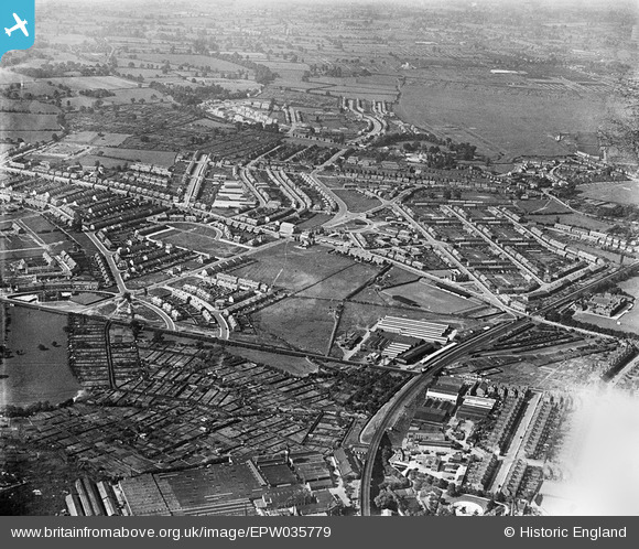
EPW035779 ENGLAND (1931). Housing off Barkers' Butts Lane and environs, Coventry, 1931
© Copyright OpenStreetMap contributors and licensed by the OpenStreetMap Foundation. 2026. Cartography is licensed as CC BY-SA.
Nearby Images (2)
EPW035779

EPW019735

Details
| Title | [EPW035779] Housing off Barkers' Butts Lane and environs, Coventry, 1931 |
| Reference | EPW035779 |
| Date | 1-July-1931 |
| Link | |
| Place name | COVENTRY |
| Parish | |
| District | |
| Country | ENGLAND |
| Easting / Northing | 432306, 279898 |
| Longitude / Latitude | -1.5249538310345, 52.415746635576 |
| National Grid Reference | SP323799 |
Pins

Oldgoat |
Thursday 9th of May 2024 07:57:21 AM | |
|
Lewis Handy |
Tuesday 10th of November 2020 05:06:59 PM | |
|
Lewis Handy |
Tuesday 10th of November 2020 05:06:29 PM | |
|
Ralph Pomeroy |
Friday 27th of April 2018 11:52:18 AM | |

offshoredaze |
Wednesday 11th of February 2015 12:31:49 PM | |
|
offshoredaze |
Wednesday 11th of February 2015 12:13:02 PM | |
|
offshoredaze |
Wednesday 11th of February 2015 12:11:34 PM | |
|
offshoredaze |
Wednesday 11th of February 2015 12:10:15 PM | |
|
offshoredaze |
Wednesday 11th of February 2015 12:09:27 PM | |
|
offshoredaze |
Wednesday 11th of February 2015 12:08:22 PM | |
|
offshoredaze |
Wednesday 11th of February 2015 12:07:09 PM | |
|
Dean |
Tuesday 3rd of December 2013 10:38:50 PM | |
|
Dean |
Tuesday 3rd of December 2013 10:36:54 PM | |
|
Dean |
Tuesday 3rd of December 2013 10:35:23 PM | |
|
Dean |
Friday 15th of November 2013 02:44:55 PM | |
|
JG |
Friday 22nd of February 2013 09:06:27 PM | |
|
JG |
Friday 22nd of February 2013 09:05:53 PM | |
|
JG |
Friday 22nd of February 2013 09:01:17 PM | |
|
JG |
Thursday 31st of January 2013 03:12:42 PM | |
|
JG |
Thursday 31st of January 2013 03:11:39 PM | |
|
JG |
Thursday 31st of January 2013 03:09:55 PM | |
|
JG |
Thursday 31st of January 2013 03:08:51 PM |

