
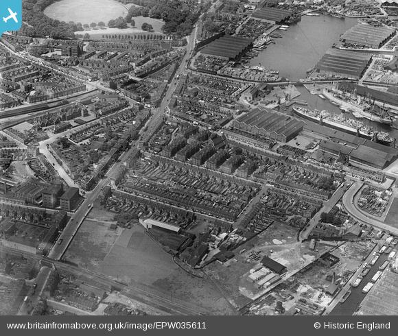
EPW035611 ENGLAND (1931). Lower Road and Sutton Dwellings at Chilton Grove and environs, Rotherhithe, 1931
© Copyright OpenStreetMap contributors and licensed by the OpenStreetMap Foundation. 2026. Cartography is licensed as CC BY-SA.
Nearby Images (20)
EPW035611

EPW036266

EPW035608

EPW035609

EPW036268

EPW035612

EPW036267

EPW036264

EPW035610

EPW036263

EPW035613

EAW033237

EAW033240

EAW033239

EAW033238

EAW033242

EAW033184

EAW033182

EAW033236

EPW044145

Details
| Title | [EPW035611] Lower Road and Sutton Dwellings at Chilton Grove and environs, Rotherhithe, 1931 |
| Reference | EPW035611 |
| Date | June-1931 |
| Link | |
| Place name | ROTHERHITHE |
| Parish | |
| District | |
| Country | ENGLAND |
| Easting / Northing | 536002, 178769 |
| Longitude / Latitude | -0.04078882000087, 51.491004078284 |
| National Grid Reference | TQ360788 |
Pins

John Wass |
Sunday 20th of September 2020 03:17:29 PM | |
|
Stu Giles |
Saturday 15th of December 2018 04:16:16 PM | |
|
Stu Giles |
Saturday 15th of December 2018 04:03:38 PM | |
|
Stu Giles |
Saturday 15th of December 2018 04:00:01 PM | |
|
Stu Giles |
Saturday 15th of December 2018 03:56:45 PM | |
|
Stu Giles |
Saturday 15th of December 2018 03:54:03 PM | |
|
Stu Giles |
Saturday 15th of December 2018 03:51:40 PM | |
|
Stu Giles |
Saturday 15th of December 2018 03:47:40 PM | |
|
Mike Floate |
Tuesday 6th of May 2014 04:34:40 PM |
