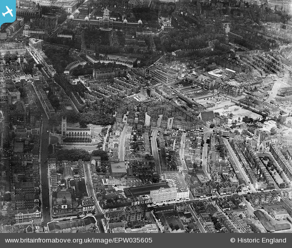
EPW035605 ENGLAND (1931). St Luke's Church, Sutton Model Dwellings and environs, Chelsea, 1931
© Copyright OpenStreetMap contributors and licensed by the OpenStreetMap Foundation. 2026. Cartography is licensed as CC BY-SA.
Nearby Images (12)
Details
| Title | [EPW035605] St Luke's Church, Sutton Model Dwellings and environs, Chelsea, 1931 |
| Reference | EPW035605 |
| Date | June-1931 |
| Link | |
| Place name | CHELSEA |
| Parish | |
| District | |
| Country | ENGLAND |
| Easting / Northing | 527260, 178453 |
| Longitude / Latitude | -0.16676614890565, 51.49019948327 |
| National Grid Reference | TQ273785 |
Pins

Alan McFaden |
Friday 18th of April 2014 10:18:14 PM | |

Alan McFaden |
Friday 18th of April 2014 10:15:32 PM | |

Alan McFaden |
Friday 18th of April 2014 10:14:25 PM | |

Alan McFaden |
Friday 18th of April 2014 10:13:07 PM |


![[EPW035605] St Luke's Church, Sutton Model Dwellings and environs, Chelsea, 1931](http://britainfromabove.org.uk/sites/all/libraries/aerofilms-images/public/100x100/EPW/035/EPW035605.jpg)
![[EPW036274] St Luke's Church, Sutton Model Dwellings and environs, Chelsea, 1931](http://britainfromabove.org.uk/sites/all/libraries/aerofilms-images/public/100x100/EPW/036/EPW036274.jpg)
![[EPW035607] St Luke's Church, Sutton Model Dwellings and environs, Chelsea, 1931](http://britainfromabove.org.uk/sites/all/libraries/aerofilms-images/public/100x100/EPW/035/EPW035607.jpg)
![[EPW036272] St Luke's Church, Sutton Model Dwellings and Cale Street, Chelsea, 1931](http://britainfromabove.org.uk/sites/all/libraries/aerofilms-images/public/100x100/EPW/036/EPW036272.jpg)
![[EPW035606] St Luke's Church, Sutton Model Dwellings and environs, Chelsea, 1931](http://britainfromabove.org.uk/sites/all/libraries/aerofilms-images/public/100x100/EPW/035/EPW035606.jpg)
![[EPW036269] St Luke's Church, Sutton Model Dwellings and Cale Street, Chelsea, 1931](http://britainfromabove.org.uk/sites/all/libraries/aerofilms-images/public/100x100/EPW/036/EPW036269.jpg)
![[EPW036273] Sutton Model Dwellings off Cale Street and environs, Chelsea, 1931](http://britainfromabove.org.uk/sites/all/libraries/aerofilms-images/public/100x100/EPW/036/EPW036273.jpg)
![[EPW036276] St Luke's Church, Sutton Model Dwellings and environs, Chelsea, 1931](http://britainfromabove.org.uk/sites/all/libraries/aerofilms-images/public/100x100/EPW/036/EPW036276.jpg)
![[EPW036270] The Samuel Lewis Trust Dwellings, St Luke's Church and environs, Chelsea, 1931. This image has been produced from a double-exposed copy-negative.](http://britainfromabove.org.uk/sites/all/libraries/aerofilms-images/public/100x100/EPW/036/EPW036270.jpg)
![[EPW036271] Sutton Model Dwellings off Cale Street and environs, Chelsea, 1931](http://britainfromabove.org.uk/sites/all/libraries/aerofilms-images/public/100x100/EPW/036/EPW036271.jpg)
![[EPW036275] Sutton Model Dwellings off Cale Street and environs, Chelsea, 1931](http://britainfromabove.org.uk/sites/all/libraries/aerofilms-images/public/100x100/EPW/036/EPW036275.jpg)
![[EPW060779] Central London from Brompton Cemetery looking towards Buckingham Palace and beyond, Chelsea, from the south-west, 1939](http://britainfromabove.org.uk/sites/all/libraries/aerofilms-images/public/100x100/EPW/060/EPW060779.jpg)


