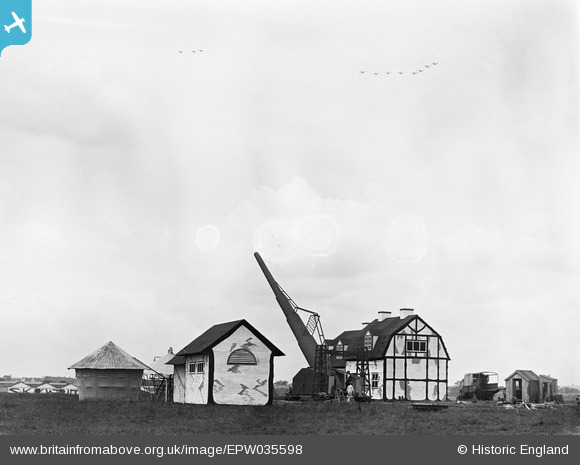
EPW035598 ENGLAND (1931). Mock bombing targets at the RAF Display, 1931
© Copyright OpenStreetMap contributors and licensed by the OpenStreetMap Foundation. 2026. Cartography is licensed as CC BY-SA.
Nearby Images (34)
Details
| Title | [EPW035598] Mock bombing targets at the RAF Display, 1931 |
| Reference | EPW035598 |
| Date | 19-June-1931 |
| Link | |
| Place name | HENDON |
| Parish | |
| District | |
| Country | ENGLAND |
| Easting / Northing | 521665, 190439 |
| Longitude / Latitude | -0.24317774789009, 51.59916406272 |
| National Grid Reference | TQ217904 |
Pins
Be the first to add a comment to this image!


![[EPW035597] Mock bombing targets at the RAF Display, 1931. This image was marked by Aerofilms Ltd for photo editing.](http://britainfromabove.org.uk/sites/all/libraries/aerofilms-images/public/100x100/EPW/035/EPW035597.jpg)
![[EPW035598] Mock bombing targets at the RAF Display, 1931](http://britainfromabove.org.uk/sites/all/libraries/aerofilms-images/public/100x100/EPW/035/EPW035598.jpg)
![[EPW008762] RAF Pageant, Hendon, 1923](http://britainfromabove.org.uk/sites/all/libraries/aerofilms-images/public/100x100/EPW/008/EPW008762.jpg)
![[EPW010852] Hendon, the aerial bombardment display including model tanks and ships at the RAF Pageant, 1924](http://britainfromabove.org.uk/sites/all/libraries/aerofilms-images/public/100x100/EPW/010/EPW010852.jpg)
![[EPW008753] Hendon, the aerial bombardment display at the RAF Pageant, 1923](http://britainfromabove.org.uk/sites/all/libraries/aerofilms-images/public/100x100/EPW/008/EPW008753.jpg)
![[EPW008754] Hendon, the aerial bombardment display at the RAF Pageant, 1923](http://britainfromabove.org.uk/sites/all/libraries/aerofilms-images/public/100x100/EPW/008/EPW008754.jpg)
![[EPW008755] Hendon, the aerial bombardment display at the RAF Pageant, 1923](http://britainfromabove.org.uk/sites/all/libraries/aerofilms-images/public/100x100/EPW/008/EPW008755.jpg)
![[EPW008755A] Hendon, the aerial bombardment display at the RAF Pageant, 1923](http://britainfromabove.org.uk/sites/all/libraries/aerofilms-images/public/100x100/EPW/008/EPW008755A.jpg)
![[EPW008756] Hendon, the aerial bombardment display at the RAF Pageant, 1923](http://britainfromabove.org.uk/sites/all/libraries/aerofilms-images/public/100x100/EPW/008/EPW008756.jpg)
![[EPW021487] Hendon, eight Fairey IIIF aircraft flying in formation very low over the airfield at the RAF Pageant, 1928](http://britainfromabove.org.uk/sites/all/libraries/aerofilms-images/public/100x100/EPW/021/EPW021487.jpg)
![[EPW021488] Hendon, nine Hawker "Horsley" aircraft flying in formation and one unidentified aircraft at the RAF Pageant, 1928](http://britainfromabove.org.uk/sites/all/libraries/aerofilms-images/public/100x100/EPW/021/EPW021488.jpg)
![[EPW021489] Hendon, a Vickers "Virginia" aircraft in flight at the RAF Pageant, 1928](http://britainfromabove.org.uk/sites/all/libraries/aerofilms-images/public/100x100/EPW/021/EPW021489.jpg)
![[EPW021570] Hendon, twelve aircraft flying in formation during the RAF Pageant rehearsal, 1928. This image has been produced from a damaged negative.](http://britainfromabove.org.uk/sites/all/libraries/aerofilms-images/public/100x100/EPW/021/EPW021570.jpg)
![[EPW021571] Hendon, four aircraft flying low over a mock-up oil refinery during the RAF Pageant rehearsal, 1928](http://britainfromabove.org.uk/sites/all/libraries/aerofilms-images/public/100x100/EPW/021/EPW021571.jpg)
![[EPW021572] Hendon, an Avro 504N aircraft parked next to a mock-up long-range gun during the RAF Pageant rehearsal, 1928](http://britainfromabove.org.uk/sites/all/libraries/aerofilms-images/public/100x100/EPW/021/EPW021572.jpg)
![[EPW021573] Hendon, three Handley Page "Hyderabad" aircraft flying very low over a mock-up oil refinery during the RAF Pageant rehearsal, 1928. This image has been produced from a damaged negative.](http://britainfromabove.org.uk/sites/all/libraries/aerofilms-images/public/100x100/EPW/021/EPW021573.jpg)
![[EPW021574] Hendon, a group of RAF personnel gathered around the muzzle of a mock-up long-range gun beside a parked Avro 504N aircraft at the RAF Pageant rehearsal, 1928](http://britainfromabove.org.uk/sites/all/libraries/aerofilms-images/public/100x100/EPW/021/EPW021574.jpg)
![[EPW022375] Hendon, De Havilland DH60 "Moth" aircraft G-EBZT with Aerofilms Ltd livery in flight over Hendon aerodrome, 1928](http://britainfromabove.org.uk/sites/all/libraries/aerofilms-images/public/100x100/EPW/022/EPW022375.jpg)
![[EPW022376] Hendon, De Havilland DH60 "Moth" aircraft G-EBZT with Aerofilms Ltd livery in flight over Hendon aerodrome, 1928](http://britainfromabove.org.uk/sites/all/libraries/aerofilms-images/public/100x100/EPW/022/EPW022376.jpg)
![[EAW021741] RAF Hendon and environs, Colindale, 1949](http://britainfromabove.org.uk/sites/all/libraries/aerofilms-images/public/100x100/EAW/021/EAW021741.jpg)
![[EPW018788] Hendon, crowds of spectators at the RAF Pageant, 1927](http://britainfromabove.org.uk/sites/all/libraries/aerofilms-images/public/100x100/EPW/018/EPW018788.jpg)
![[EPW018789] Hendon, nine De Havilland DH9A aircraft flying in formation at the RAF Pageant, 1927](http://britainfromabove.org.uk/sites/all/libraries/aerofilms-images/public/100x100/EPW/018/EPW018789.jpg)
![[EPW018790] Hendon, an Avro 504 aircraft flying very low over parked aircraft at the RAF Pageant, 1927](http://britainfromabove.org.uk/sites/all/libraries/aerofilms-images/public/100x100/EPW/018/EPW018790.jpg)
![[EPW018791] Hendon, four Vickers "Virginia" aircraft flying in formation very low in front of a blimp and model village at the RAF Pageant, 1927](http://britainfromabove.org.uk/sites/all/libraries/aerofilms-images/public/100x100/EPW/018/EPW018791.jpg)
![[EPW018792] Hendon, nine Fairey "Fox" aircraft flying in formation at the RAF Pageant, 1927](http://britainfromabove.org.uk/sites/all/libraries/aerofilms-images/public/100x100/EPW/018/EPW018792.jpg)
![[EPW018793] Hendon, a Handley Page "Hyderabad" aircraft parked on the airfield at the RAF Pageant, 1927](http://britainfromabove.org.uk/sites/all/libraries/aerofilms-images/public/100x100/EPW/018/EPW018793.jpg)
![[EPW018794] Hendon, six De Havilland DH60 "Genet-Moth" aircraft flying in formation in front of a blimp and model village at the RAF Pageant, 1927](http://britainfromabove.org.uk/sites/all/libraries/aerofilms-images/public/100x100/EPW/018/EPW018794.jpg)
![[EPW018795] Hendon, spectators climbing on hoardings being moved on by mounted police at the RAF Pageant, 1927](http://britainfromabove.org.uk/sites/all/libraries/aerofilms-images/public/100x100/EPW/018/EPW018795.jpg)
![[EPW018796] Hendon, the airfield carpark with parked aircraft lined up in the background at the RAF Pageant, 1927](http://britainfromabove.org.uk/sites/all/libraries/aerofilms-images/public/100x100/EPW/018/EPW018796.jpg)
![[EPW018797] Hendon, the airfield carpark with parked aircraft lined up in the background at the RAF Pageant, 1927](http://britainfromabove.org.uk/sites/all/libraries/aerofilms-images/public/100x100/EPW/018/EPW018797.jpg)
![[EPW018798] Hendon, a De Havilland DH60 "Genet-Moth" in flight at the RAF Pageant, 1927](http://britainfromabove.org.uk/sites/all/libraries/aerofilms-images/public/100x100/EPW/018/EPW018798.jpg)
![[EPW010853] Five Nieuport-Delage 29.C.1 aircraft in flight for the RAF Aerial Pageant, 1924](http://britainfromabove.org.uk/sites/all/libraries/aerofilms-images/public/100x100/EPW/010/EPW010853.jpg)
![[EPW038690] The Society of British Aircraft Constructors display at the Hendon Aerodrome, Hendon, 1932](http://britainfromabove.org.uk/sites/all/libraries/aerofilms-images/public/100x100/EPW/038/EPW038690.jpg)
![[EPW006836] Colindale, RAF Pageant at the London Aerodrome (RAF Hendon), from the south-east, 1921. This image has been produced from a print.](http://britainfromabove.org.uk/sites/all/libraries/aerofilms-images/public/100x100/EPW/006/EPW006836.jpg)