
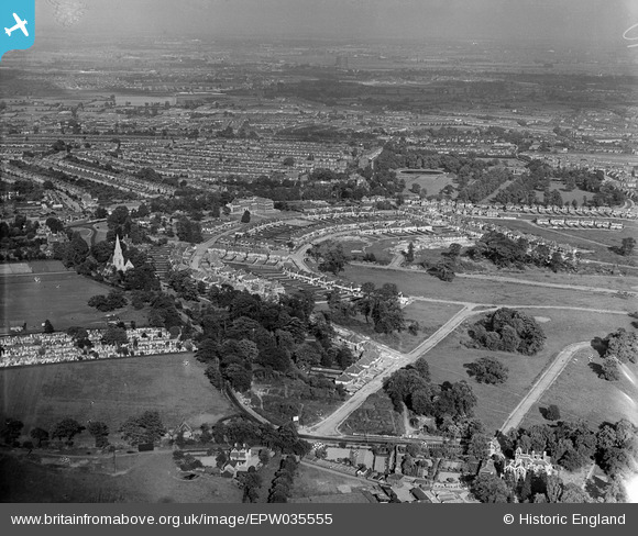
EPW035555 ENGLAND (1931). Housing at Arnos Grove, Christ Church and environs, New Southgate, from the west, 1931
© Copyright OpenStreetMap contributors and licensed by the OpenStreetMap Foundation. 2026. Cartography is licensed as CC BY-SA.
Nearby Images (2)
EPW035555

EPW031510

Details
| Title | [EPW035555] Housing at Arnos Grove, Christ Church and environs, New Southgate, from the west, 1931 |
| Reference | EPW035555 |
| Date | June-1931 |
| Link | |
| Place name | NEW SOUTHGATE |
| Parish | |
| District | |
| Country | ENGLAND |
| Easting / Northing | 529411, 193293 |
| Longitude / Latitude | -0.13033513862708, 51.623087804683 |
| National Grid Reference | TQ294933 |
Pins

Ray Flack |
Wednesday 8th of January 2014 04:24:59 AM | |
|
Ray Flack |
Wednesday 8th of January 2014 04:18:21 AM | |
|
Ray Flack |
Wednesday 8th of January 2014 04:16:26 AM | |
|
Ray Flack |
Wednesday 8th of January 2014 04:07:36 AM | |
|
Ray Flack |
Wednesday 8th of January 2014 03:56:39 AM | |
|
Ray Flack |
Wednesday 8th of January 2014 03:54:42 AM | |
|
Ray Flack |
Wednesday 8th of January 2014 03:26:27 AM | |
|
Ray Flack |
Wednesday 8th of January 2014 03:23:29 AM | |
|
Ray Flack |
Wednesday 8th of January 2014 03:22:24 AM | |
|
Ray Flack |
Wednesday 8th of January 2014 03:20:14 AM | |
|
Ray Flack |
Wednesday 8th of January 2014 02:35:42 AM | |
|
Ray Flack |
Wednesday 8th of January 2014 02:24:18 AM | |
|
Ray Flack |
Wednesday 8th of January 2014 02:22:53 AM | |

Class31 |
Wednesday 27th of March 2013 09:03:22 PM | |
|
Class31 |
Wednesday 27th of March 2013 09:02:05 PM | |
|
Class31 |
Wednesday 27th of March 2013 08:57:55 PM |