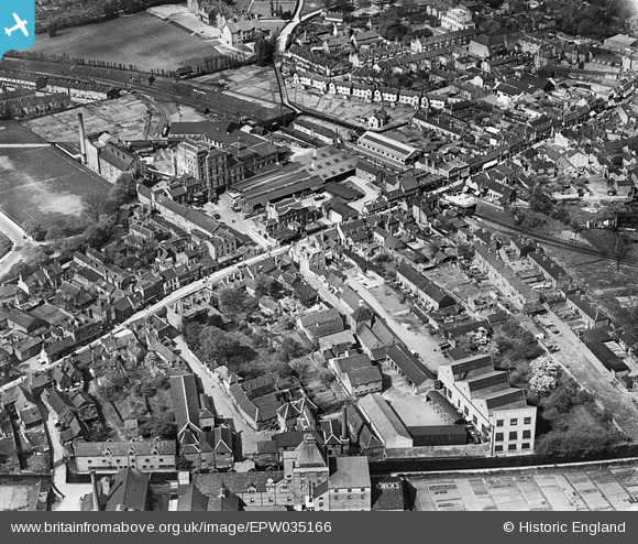
EPW035166 ENGLAND (1931). Benskins Brewery and the town, Watford, 1931
© Copyright OpenStreetMap contributors and licensed by the OpenStreetMap Foundation. 2026. Cartography is licensed as CC BY-SA.
Nearby Images (22)
Details
| Title | [EPW035166] Benskins Brewery and the town, Watford, 1931 |
| Reference | EPW035166 |
| Date | May-1931 |
| Link | |
| Place name | WATFORD |
| Parish | |
| District | |
| Country | ENGLAND |
| Easting / Northing | 511443, 196044 |
| Longitude / Latitude | -0.38893220900084, 51.651661832043 |
| National Grid Reference | TQ114960 |
Pins
Be the first to add a comment to this image!


![[EPW035166] Benskins Brewery and the town, Watford, 1931](http://britainfromabove.org.uk/sites/all/libraries/aerofilms-images/public/100x100/EPW/035/EPW035166.jpg)
![[EPW035164] Benskins Brewery and the town, Watford, 1931](http://britainfromabove.org.uk/sites/all/libraries/aerofilms-images/public/100x100/EPW/035/EPW035164.jpg)
![[EPW035167] Benskins Brewery and the town, Watford, 1931](http://britainfromabove.org.uk/sites/all/libraries/aerofilms-images/public/100x100/EPW/035/EPW035167.jpg)
![[EAW026503] High Street and the town, Watford, from the south-east, 1949](http://britainfromabove.org.uk/sites/all/libraries/aerofilms-images/public/100x100/EAW/026/EAW026503.jpg)
![[EPW035165] Benskins Brewery and the town, Watford, 1931](http://britainfromabove.org.uk/sites/all/libraries/aerofilms-images/public/100x100/EPW/035/EPW035165.jpg)
![[EPW034812] Benskins Brewery and environs, Watford, 1931](http://britainfromabove.org.uk/sites/all/libraries/aerofilms-images/public/100x100/EPW/034/EPW034812.jpg)
![[EPW035129] Benskins Brewery and the town, Watford, 1931](http://britainfromabove.org.uk/sites/all/libraries/aerofilms-images/public/100x100/EPW/035/EPW035129.jpg)
![[EPW035163] Benskins Brewery and the town, Watford, 1931](http://britainfromabove.org.uk/sites/all/libraries/aerofilms-images/public/100x100/EPW/035/EPW035163.jpg)
![[EPW034809] Watford High Street, Benskins Brewery and environs, Watford, 1931](http://britainfromabove.org.uk/sites/all/libraries/aerofilms-images/public/100x100/EPW/034/EPW034809.jpg)
![[EPW034811] Watford High Street, Benskins Brewery and environs, Watford, 1931](http://britainfromabove.org.uk/sites/all/libraries/aerofilms-images/public/100x100/EPW/034/EPW034811.jpg)
![[EPW034808] Watford High Street, Benskins Brewery and environs, Watford, 1931](http://britainfromabove.org.uk/sites/all/libraries/aerofilms-images/public/100x100/EPW/034/EPW034808.jpg)
![[EPW034814] Benskins Brewery and environs, Watford, 1931](http://britainfromabove.org.uk/sites/all/libraries/aerofilms-images/public/100x100/EPW/034/EPW034814.jpg)
![[EPW034779] Benskins Brewery and environs, Watford, 1931](http://britainfromabove.org.uk/sites/all/libraries/aerofilms-images/public/100x100/EPW/034/EPW034779.jpg)
![[EPW034813] Benskins Brewery and environs, Watford, 1931](http://britainfromabove.org.uk/sites/all/libraries/aerofilms-images/public/100x100/EPW/034/EPW034813.jpg)
![[EPW034807] Benskins Brewery and environs, Watford, 1931](http://britainfromabove.org.uk/sites/all/libraries/aerofilms-images/public/100x100/EPW/034/EPW034807.jpg)
![[EPW034781] Benskins Brewery and environs, Watford, 1931](http://britainfromabove.org.uk/sites/all/libraries/aerofilms-images/public/100x100/EPW/034/EPW034781.jpg)
![[EPW034810] Benskins Brewery and environs, Watford, 1931](http://britainfromabove.org.uk/sites/all/libraries/aerofilms-images/public/100x100/EPW/034/EPW034810.jpg)
![[EAW022727] The High Street and town, Watford, from the south-east, 1949](http://britainfromabove.org.uk/sites/all/libraries/aerofilms-images/public/100x100/EAW/022/EAW022727.jpg)
![[EPW035168] Benskins Brewery and the town, Watford, 1931](http://britainfromabove.org.uk/sites/all/libraries/aerofilms-images/public/100x100/EPW/035/EPW035168.jpg)
![[EPW034780] Benskins Brewery and environs, Watford, 1931](http://britainfromabove.org.uk/sites/all/libraries/aerofilms-images/public/100x100/EPW/034/EPW034780.jpg)
![[EAW026504] High Street and the town, Watford, from the south-east, 1949](http://britainfromabove.org.uk/sites/all/libraries/aerofilms-images/public/100x100/EAW/026/EAW026504.jpg)
![[EAW002186] The town centre, Watford, from the south-east, 1946](http://britainfromabove.org.uk/sites/all/libraries/aerofilms-images/public/100x100/EAW/002/EAW002186.jpg)