
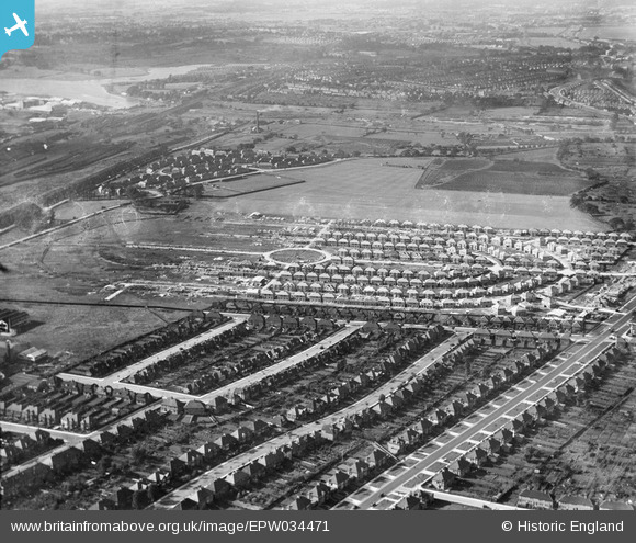
EPW034471 ENGLAND (1930). Housing under construction at Pennine Drive and environs, Golders Green, from the south-east, 1930
© Copyright OpenStreetMap contributors and licensed by the OpenStreetMap Foundation. 2026. Cartography is licensed as CC BY-SA.
Nearby Images (9)
EPW034471

EPW034467

EPW034469

EPW034466

EPW038718

EPW034463

EPW034462

EPW034464

EPW034470

Details
| Title | [EPW034471] Housing under construction at Pennine Drive and environs, Golders Green, from the south-east, 1930 |
| Reference | EPW034471 |
| Date | August-1930 |
| Link | |
| Place name | GOLDERS GREEN |
| Parish | |
| District | |
| Country | ENGLAND |
| Easting / Northing | 524190, 186723 |
| Longitude / Latitude | -0.20805078310751, 51.565213566436 |
| National Grid Reference | TQ242867 |
Pins

SB83 |
Tuesday 11th of February 2014 12:34:20 AM | |
|
SB83 |
Monday 10th of February 2014 06:07:39 PM | |
|
SB83 |
Monday 10th of February 2014 06:07:18 PM | |
|
SB83 |
Monday 10th of February 2014 06:03:32 PM | |
|
SB83 |
Monday 10th of February 2014 06:03:14 PM | |
|
SB83 |
Monday 10th of February 2014 06:03:00 PM | |
|
SB83 |
Monday 10th of February 2014 06:02:41 PM | |
|
SB83 |
Monday 10th of February 2014 06:02:24 PM | |
|
SB83 |
Monday 10th of February 2014 06:01:36 PM | |
|
SB83 |
Monday 10th of February 2014 06:01:22 PM | |
|
SB83 |
Monday 10th of February 2014 06:00:53 PM | |
|
SB83 |
Monday 10th of February 2014 06:00:35 PM |