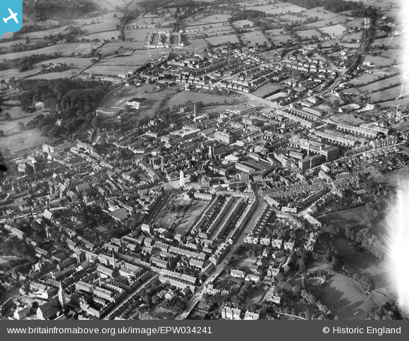
EPW034241 ENGLAND (1930). St Luke's Church, the war memorial and the town centre, Leek, 1930
© Copyright OpenStreetMap contributors and licensed by the OpenStreetMap Foundation. 2026. Cartography is licensed as CC BY-SA.
Nearby Images (20)
Details
| Title | [EPW034241] St Luke's Church, the war memorial and the town centre, Leek, 1930 |
| Reference | EPW034241 |
| Date | July-1930 |
| Link | |
| Place name | LEEK |
| Parish | LEEK |
| District | |
| Country | ENGLAND |
| Easting / Northing | 398788, 356555 |
| Longitude / Latitude | -2.0181058701639, 53.105890394095 |
| National Grid Reference | SJ988566 |
Pins

Gavin Wood |
Tuesday 17th of November 2020 11:19:50 PM | |

Rob |
Monday 30th of April 2018 08:53:56 PM | |

David960 |
Monday 2nd of May 2016 04:51:36 PM | |

melgibbs |
Wednesday 20th of August 2014 02:45:52 PM | |

Class31 |
Wednesday 2nd of October 2013 10:56:48 PM | |

Class31 |
Wednesday 2nd of October 2013 10:55:40 PM | |

Class31 |
Wednesday 2nd of October 2013 10:54:11 PM | |

Class31 |
Wednesday 2nd of October 2013 10:53:50 PM |


![[EPW034241] St Luke's Church, the war memorial and the town centre, Leek, 1930](http://britainfromabove.org.uk/sites/all/libraries/aerofilms-images/public/100x100/EPW/034/EPW034241.jpg)
![[EPW034246] The War Memorial and environs, Leek, 1930](http://britainfromabove.org.uk/sites/all/libraries/aerofilms-images/public/100x100/EPW/034/EPW034246.jpg)
![[EPW046320] Brough, Nicholson & Hall Hope Silk Mill, War Memorial and the town centre, Leek, 1934](http://britainfromabove.org.uk/sites/all/libraries/aerofilms-images/public/100x100/EPW/046/EPW046320.jpg)
![[EPW046323] Brough, Nicholson & Hall Hope Silk Mill and environs, Leek, 1934](http://britainfromabove.org.uk/sites/all/libraries/aerofilms-images/public/100x100/EPW/046/EPW046323.jpg)
![[EPW046322] Brough, Nicholson & Hall Hope Silk Mill and the town centre, Leek, 1934](http://britainfromabove.org.uk/sites/all/libraries/aerofilms-images/public/100x100/EPW/046/EPW046322.jpg)
![[EPW046315] Brough, Nicholson & Hall Hope Silk Mill, the cattle market and town centre, Leek, 1934](http://britainfromabove.org.uk/sites/all/libraries/aerofilms-images/public/100x100/EPW/046/EPW046315.jpg)
![[EPW046316] Brough, Nicholson & Hall Hope Silk Mill and the town centre, Leek, 1934](http://britainfromabove.org.uk/sites/all/libraries/aerofilms-images/public/100x100/EPW/046/EPW046316.jpg)
![[EPW046319] Brough, Nicholson & Hall Hope Silk Mill and the town centre, Leek, 1934](http://britainfromabove.org.uk/sites/all/libraries/aerofilms-images/public/100x100/EPW/046/EPW046319.jpg)
![[EPW046318] Brough, Nicholson & Hall Hope Silk Mill and environs, Leek, 1934](http://britainfromabove.org.uk/sites/all/libraries/aerofilms-images/public/100x100/EPW/046/EPW046318.jpg)
![[EAW037600] The Premier Dyeing & Finishing Co Ltd Works, Leek, 1951. This image was marked by Aerofilms Ltd for photo editing.](http://britainfromabove.org.uk/sites/all/libraries/aerofilms-images/public/100x100/EAW/037/EAW037600.jpg)
![[EAW037602] The Premier Dyeing & Finishing Co Ltd Works, Leek, 1951. This image was marked by Aerofilms Ltd for photo editing.](http://britainfromabove.org.uk/sites/all/libraries/aerofilms-images/public/100x100/EAW/037/EAW037602.jpg)
![[EPW046317] Brough, Nicholson & Hall Hope Silk Mill and the town centre, Leek, 1934](http://britainfromabove.org.uk/sites/all/libraries/aerofilms-images/public/100x100/EPW/046/EPW046317.jpg)
![[EPW046321] Brough, Nicholson & Hall Hope Silk Mill and environs, Leek, 1934](http://britainfromabove.org.uk/sites/all/libraries/aerofilms-images/public/100x100/EPW/046/EPW046321.jpg)
![[EAW037601] The Premier Dyeing & Finishing Co Ltd Works, Leek, 1951. This image was marked by Aerofilms Ltd for photo editing.](http://britainfromabove.org.uk/sites/all/libraries/aerofilms-images/public/100x100/EAW/037/EAW037601.jpg)
![[EAW037606] The Premier Dyeing & Finishing Co Ltd Works, Leek, 1951. This image has been produced from a print marked by Aerofilms Ltd for photo editing.](http://britainfromabove.org.uk/sites/all/libraries/aerofilms-images/public/100x100/EAW/037/EAW037606.jpg)
![[EAW037605] The Premier Dyeing & Finishing Co Ltd Works, Leek, 1951. This image has been produced from a print marked by Aerofilms Ltd for photo editing.](http://britainfromabove.org.uk/sites/all/libraries/aerofilms-images/public/100x100/EAW/037/EAW037605.jpg)
![[EAW037604] The Premier Dyeing & Finishing Co Ltd Works, Leek, 1951. This image has been produced from a print marked by Aerofilms Ltd for photo editing.](http://britainfromabove.org.uk/sites/all/libraries/aerofilms-images/public/100x100/EAW/037/EAW037604.jpg)
![[EAW037603] The Premier Dyeing & Finishing Co Ltd Works, Leek, 1951. This image was marked by Aerofilms Ltd for photo editing.](http://britainfromabove.org.uk/sites/all/libraries/aerofilms-images/public/100x100/EAW/037/EAW037603.jpg)
![[EPW034242] The town centre, Leek, 1930](http://britainfromabove.org.uk/sites/all/libraries/aerofilms-images/public/100x100/EPW/034/EPW034242.jpg)
![[EPW046308] Ashbourne Road and the town, Leek, from the south-east, 1934](http://britainfromabove.org.uk/sites/all/libraries/aerofilms-images/public/100x100/EPW/046/EPW046308.jpg)