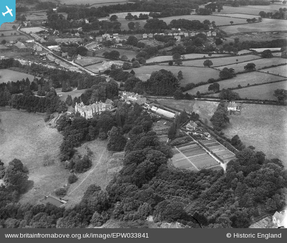
EPW033841 ENGLAND (1930). St Andrew's School (later the Abbey School), Ashurst Wood, 1930
© Copyright OpenStreetMap contributors and licensed by the OpenStreetMap Foundation. 2025. Cartography is licensed as CC BY-SA.
Nearby Images (6)
Details
| Title | [EPW033841] St Andrew's School (later the Abbey School), Ashurst Wood, 1930 |
| Reference | EPW033841 |
| Date | July-1930 |
| Link | |
| Place name | ASHURST WOOD |
| Parish | ASHURST WOOD |
| District | |
| Country | ENGLAND |
| Easting / Northing | 542521, 136664 |
| Longitude / Latitude | 0.03624049861101, 51.110997122209 |
| National Grid Reference | TQ425367 |
Pins

Keith Andrews |
Tuesday 11th of July 2023 06:41:52 PM |


![[EPW033841] St Andrew's School (later the Abbey School), Ashurst Wood, 1930](http://britainfromabove.org.uk/sites/all/libraries/aerofilms-images/public/100x100/EPW/033/EPW033841.jpg)
![[EPW033846] St Andrew's School (later the Abbey School), Ashurst Wood, 1930](http://britainfromabove.org.uk/sites/all/libraries/aerofilms-images/public/100x100/EPW/033/EPW033846.jpg)
![[EPW033842] St Andrew's School (later the Abbey School), Ashurst Wood, 1930](http://britainfromabove.org.uk/sites/all/libraries/aerofilms-images/public/100x100/EPW/033/EPW033842.jpg)
![[EPW033843] St Andrew's School (later the Abbey School), Ashurst Wood, 1930](http://britainfromabove.org.uk/sites/all/libraries/aerofilms-images/public/100x100/EPW/033/EPW033843.jpg)
![[EPW033845] St Andrew's School (later the Abbey School), Ashurst Wood, 1930](http://britainfromabove.org.uk/sites/all/libraries/aerofilms-images/public/100x100/EPW/033/EPW033845.jpg)
![[EPW033844] St Andrew's School (later the Abbey School), Ashurst Wood, 1930](http://britainfromabove.org.uk/sites/all/libraries/aerofilms-images/public/100x100/EPW/033/EPW033844.jpg)