
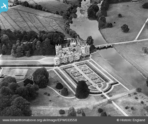
EPW033558 ENGLAND (1930). Longford Castle, Bodenham, 1930
© Copyright OpenStreetMap contributors and licensed by the OpenStreetMap Foundation. 2026. Cartography is licensed as CC BY-SA.
Nearby Images (8)
EPW033558

EPW033556

EAW025824

EAW025823

EPW033559

EPW033557

EAW025825

EAW025822

Details
| Title | [EPW033558] Longford Castle, Bodenham, 1930 |
| Reference | EPW033558 |
| Date | July-1930 |
| Link | |
| Place name | BODENHAM |
| Parish | ODSTOCK |
| District | |
| Country | ENGLAND |
| Easting / Northing | 417144, 126654 |
| Longitude / Latitude | -1.7554519011246, 51.03845069406 |
| National Grid Reference | SU171267 |
Pins

Maurice |
Wednesday 12th of December 2012 07:09:10 AM |
User Comment Contributions
At one time, water meadows were an important technique in the management of floodplain farmland. A leat (small canal) was constructed to branch off from the main stream above the site, the flow of water being controlled by a sluice gate. The release of water into a system of distribution channels allowed irrigation when required. Excess water was drained off from the meadows by another separate set of channels, returning the water to the main stream below the site. Careful observation of the picture allows these two patterns to be seen. The feeder channels are larger and straight, while the slightly lower drains are more of herring bone pattern within the rectangles made by the former. This set of meadows is still visible on today satellite pictures, being just south east of Salisbury on the Avon. There is another set of meadows at Harnham in Salisbury that make an important element in the unchanging scene to the west of the Cathedral. http://en.wikipedia.org/wiki/Water-meadow http://www.salisburywatermeadows.org.uk/ Some have suggested that the decline of water meadows is an element, albeit a small one, in the causes of modern flooding. Their reintroduction would certainly help retard the flow of water down stream. The system would perhaps more importantly arrest the loss of top soil carried down stream during flood episodes as the water meadows act as a filter trapping sediment and nutrients that improve the land. |
Maurice |
Wednesday 12th of December 2012 08:04:55 AM |