
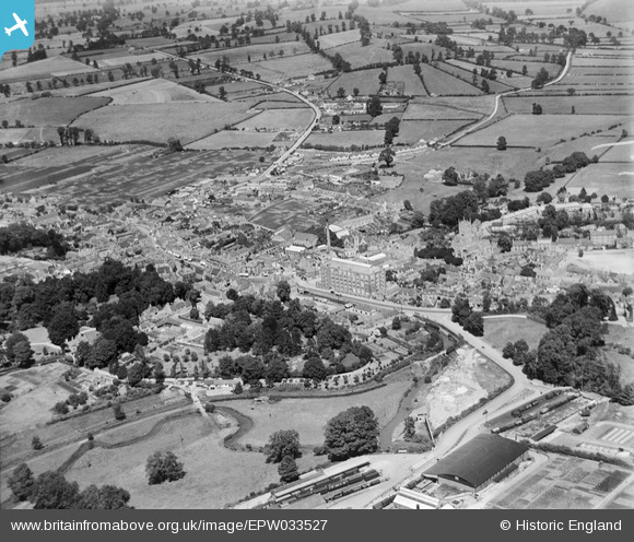
EPW033527 ENGLAND (1930). The town centre, Calne, from the south-west, 1930
© Copyright OpenStreetMap contributors and licensed by the OpenStreetMap Foundation. 2026. Cartography is licensed as CC BY-SA.
Nearby Images (28)
EPW033527

EPW033522

EPW001114

EPR000052

EPR000050

EPR000051

EPR000054

EPW029301

EPW029302

EPW029294

EPW029289

EPW029297

EPW011115

EPW029300

EPR000047
 Ltd Bacon Factory and the town centre, Calne, 1934")
EPR000049
 Ltd By-Products Factory at the railway station, Calne, 1934")
EPR000053

EPR000046
 Ltd Bacon Factory and the town centre, Calne, 1934")
EPR000048
 Ltd Bacon Factory and the town centre, Calne, 1934")
EPW011112

EPW033520

EPW033526

EPW029293

EPW001116

EPW033517

EPR000055

EPW033515

EPW033516

Details
| Title | [EPW033527] The town centre, Calne, from the south-west, 1930 |
| Reference | EPW033527 |
| Date | July-1930 |
| Link | |
| Place name | CALNE |
| Parish | CALNE |
| District | |
| Country | ENGLAND |
| Easting / Northing | 399626, 170810 |
| Longitude / Latitude | -2.0053810198448, 51.435797405983 |
| National Grid Reference | ST996708 |
Pins

Dockgreen |
Sunday 12th of March 2017 11:58:30 AM | |
|
Dockgreen |
Sunday 12th of March 2017 11:57:31 AM | |

Class31 |
Wednesday 27th of March 2013 09:22:46 AM | |
|
Class31 |
Wednesday 27th of March 2013 09:22:06 AM | |

Maurice |
Tuesday 26th of March 2013 07:06:42 PM | |
|
MB |
Monday 25th of March 2013 09:49:56 PM | |
|
MB |
Monday 25th of March 2013 09:48:41 PM | |
|
MB |
Monday 25th of March 2013 09:47:46 PM | |
|
MB |
Monday 25th of March 2013 09:46:10 PM | |
|
MB |
Monday 25th of March 2013 09:45:43 PM | |
|
MB |
Monday 25th of March 2013 09:44:14 PM | |
|
MB |
Monday 25th of March 2013 09:43:35 PM | |
Harris' Bi-product factory building was an RFC General Service Flight Shed formerly located at Yatesbury airfield; it was a 1917 Pattern Shed approx 80' by 170' |

Steve Bedding |
Monday 3rd of June 2013 10:13:44 PM |
|
MB |
Monday 25th of March 2013 09:42:34 PM | |
|
MB |
Monday 25th of March 2013 09:41:27 PM | |
|
MB |
Monday 25th of March 2013 09:40:20 PM | |
|
MB |
Monday 25th of March 2013 09:39:49 PM | |
|
MB |
Monday 25th of March 2013 09:39:18 PM |