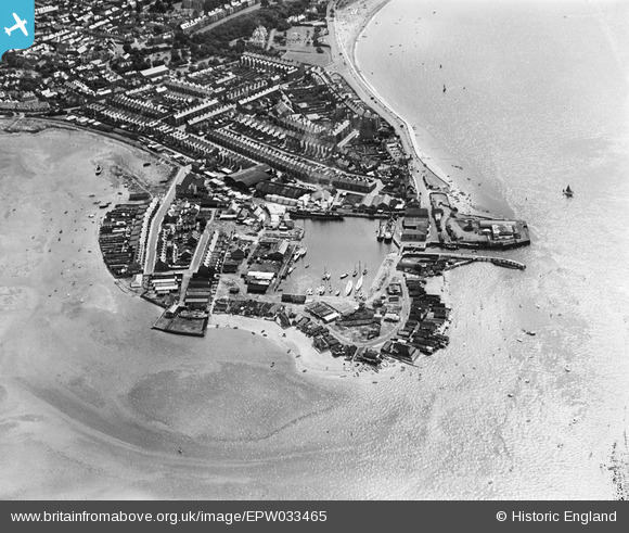
EPW033465 ENGLAND (1930). The Point, Exmouth, 1930
© Copyright OpenStreetMap contributors and licensed by the OpenStreetMap Foundation. 2026. Cartography is licensed as CC BY-SA.
Nearby Images (14)
Details
| Title | [EPW033465] The Point, Exmouth, 1930 |
| Reference | EPW033465 |
| Date | July-1930 |
| Link | |
| Place name | EXMOUTH |
| Parish | EXMOUTH |
| District | |
| Country | ENGLAND |
| Easting / Northing | 299404, 80777 |
| Longitude / Latitude | -3.4221154262712, 50.617430748504 |
| National Grid Reference | SX994808 |
Pins
Be the first to add a comment to this image!


![[EPW033465] The Point, Exmouth, 1930](http://britainfromabove.org.uk/sites/all/libraries/aerofilms-images/public/100x100/EPW/033/EPW033465.jpg)
![[EAW051152] Exmouth Dock and The Point, Exmouth, 1953](http://britainfromabove.org.uk/sites/all/libraries/aerofilms-images/public/100x100/EAW/051/EAW051152.jpg)
![[EPW033462] The Dock and Pier at The Point, Exmouth, 1930](http://britainfromabove.org.uk/sites/all/libraries/aerofilms-images/public/100x100/EPW/033/EPW033462.jpg)
![[EAW051153] Exmouth Dock, The Point and environs, Exmouth, 1953](http://britainfromabove.org.uk/sites/all/libraries/aerofilms-images/public/100x100/EAW/051/EAW051153.jpg)
![[EAW007590] Exmouth Dock, Exmouth, 1947](http://britainfromabove.org.uk/sites/all/libraries/aerofilms-images/public/100x100/EAW/007/EAW007590.jpg)
![[EPW023666] The Dock, Exmouth, 1928.](http://britainfromabove.org.uk/sites/all/libraries/aerofilms-images/public/100x100/EPW/023/EPW023666.jpg)
![[EPW023676] Pier Head and the Dock, Exmouth, 1928.](http://britainfromabove.org.uk/sites/all/libraries/aerofilms-images/public/100x100/EPW/023/EPW023676.jpg)
![[EPW039693] The docks and environs, Exmouth, 1932](http://britainfromabove.org.uk/sites/all/libraries/aerofilms-images/public/100x100/EPW/039/EPW039693.jpg)
![[EPW033463] The Point, Cockle Sand, the town and surrounding countryside, Exmouth, from the west, 1930](http://britainfromabove.org.uk/sites/all/libraries/aerofilms-images/public/100x100/EPW/033/EPW033463.jpg)
![[EPW023675] The Point, Exmouth, from the south-west, 1928.](http://britainfromabove.org.uk/sites/all/libraries/aerofilms-images/public/100x100/EPW/023/EPW023675.jpg)
![[EAW007589] Exmouth Dock and Cockle Sand, Exmouth, 1947](http://britainfromabove.org.uk/sites/all/libraries/aerofilms-images/public/100x100/EAW/007/EAW007589.jpg)
![[EAW015002] The town, Exmouth, from the south-west, 1948. This image has been produced from a print.](http://britainfromabove.org.uk/sites/all/libraries/aerofilms-images/public/100x100/EAW/015/EAW015002.jpg)
![[EPW023667] The Esplanade, Exmouth, from the west, 1928.](http://britainfromabove.org.uk/sites/all/libraries/aerofilms-images/public/100x100/EPW/023/EPW023667.jpg)
![[EPW033467] The Point, Cockle Sand, the town and surrounding countryside, Exmouth, from the west, 1930. This image has been affected by flare.](http://britainfromabove.org.uk/sites/all/libraries/aerofilms-images/public/100x100/EPW/033/EPW033467.jpg)