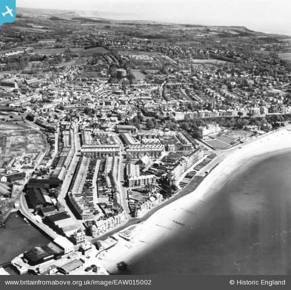
EAW015002 ENGLAND (1948). The town, Exmouth, from the south-west, 1948. This image has been produced from a print.
© Copyright OpenStreetMap contributors and licensed by the OpenStreetMap Foundation. 2026. Cartography is licensed as CC BY-SA.
Nearby Images (10)
Details
| Title | [EAW015002] The town, Exmouth, from the south-west, 1948. This image has been produced from a print. |
| Reference | EAW015002 |
| Date | 27-April-1948 |
| Link | |
| Place name | EXMOUTH |
| Parish | EXMOUTH |
| District | |
| Country | ENGLAND |
| Easting / Northing | 299561, 80622 |
| Longitude / Latitude | -3.4198546949453, 50.616064192687 |
| National Grid Reference | SX996806 |
Pins

cptpies |
Wednesday 23rd of October 2019 03:39:47 PM | |
Allen T |
Friday 12th of September 2014 05:23:03 PM | |
Allen T |
Friday 12th of September 2014 05:22:36 PM | |
Allen T |
Friday 12th of September 2014 05:22:12 PM | |
Allen T |
Friday 12th of September 2014 05:21:26 PM | |
Allen T |
Friday 12th of September 2014 05:20:14 PM | |
Allen T |
Friday 12th of September 2014 05:18:13 PM | |
Allen T |
Friday 12th of September 2014 05:17:11 PM | |
Allen T |
Friday 12th of September 2014 05:15:50 PM | |
Allen T |
Friday 12th of September 2014 05:14:11 PM |


![[EAW015002] The town, Exmouth, from the south-west, 1948. This image has been produced from a print.](http://britainfromabove.org.uk/sites/all/libraries/aerofilms-images/public/100x100/EAW/015/EAW015002.jpg)
![[EPW023667] The Esplanade, Exmouth, from the west, 1928.](http://britainfromabove.org.uk/sites/all/libraries/aerofilms-images/public/100x100/EPW/023/EPW023667.jpg)
![[EPW039693] The docks and environs, Exmouth, 1932](http://britainfromabove.org.uk/sites/all/libraries/aerofilms-images/public/100x100/EPW/039/EPW039693.jpg)
![[EAW051153] Exmouth Dock, The Point and environs, Exmouth, 1953](http://britainfromabove.org.uk/sites/all/libraries/aerofilms-images/public/100x100/EAW/051/EAW051153.jpg)
![[EAW051152] Exmouth Dock and The Point, Exmouth, 1953](http://britainfromabove.org.uk/sites/all/libraries/aerofilms-images/public/100x100/EAW/051/EAW051152.jpg)
![[EPW023676] Pier Head and the Dock, Exmouth, 1928.](http://britainfromabove.org.uk/sites/all/libraries/aerofilms-images/public/100x100/EPW/023/EPW023676.jpg)
![[EAW051154] The town and the surrounding coastline, Exmouth, from the west, 1953](http://britainfromabove.org.uk/sites/all/libraries/aerofilms-images/public/100x100/EAW/051/EAW051154.jpg)
![[EPW033465] The Point, Exmouth, 1930](http://britainfromabove.org.uk/sites/all/libraries/aerofilms-images/public/100x100/EPW/033/EPW033465.jpg)
![[EPW033462] The Dock and Pier at The Point, Exmouth, 1930](http://britainfromabove.org.uk/sites/all/libraries/aerofilms-images/public/100x100/EPW/033/EPW033462.jpg)
![[EPW023666] The Dock, Exmouth, 1928.](http://britainfromabove.org.uk/sites/all/libraries/aerofilms-images/public/100x100/EPW/023/EPW023666.jpg)