
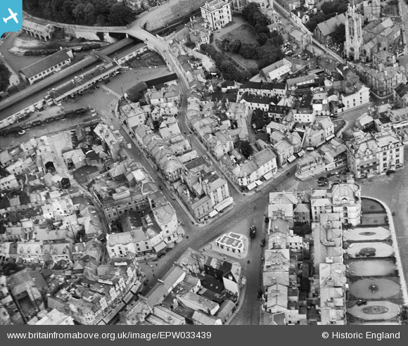
EPW033439 ENGLAND (1930). Teignmouth Railway Station, St Michael's Church and Regent Street, Teignmouth, 1930
© Copyright OpenStreetMap contributors and licensed by the OpenStreetMap Foundation. 2026. Cartography is licensed as CC BY-SA.
Nearby Images (8)
EPW033439

EPW024183

EPW024182

EPW024211

EPW033434

EPW039710

EPW033438

EPW023709

Details
| Title | [EPW033439] Teignmouth Railway Station, St Michael's Church and Regent Street, Teignmouth, 1930 |
| Reference | EPW033439 |
| Date | July-1930 |
| Link | |
| Place name | TEIGNMOUTH |
| Parish | TEIGNMOUTH |
| District | |
| Country | ENGLAND |
| Easting / Northing | 294234, 72980 |
| Longitude / Latitude | -3.4929588415215, 50.546414137845 |
| National Grid Reference | SX942730 |
Pins

Sco172 |
Tuesday 20th of February 2024 01:13:09 PM | |
|
Sco172 |
Tuesday 20th of February 2024 01:11:05 PM | |
|
Sco172 |
Tuesday 20th of February 2024 01:10:23 PM | |
|
Sco172 |
Tuesday 20th of February 2024 01:10:04 PM | |
|
John W |
Friday 26th of August 2016 09:34:29 PM | |
|
John W |
Friday 26th of August 2016 09:33:15 PM | |

Class31 |
Saturday 9th of May 2015 07:23:17 PM | |
|
Class31 |
Saturday 9th of May 2015 07:17:20 PM | |
|
Class31 |
Saturday 9th of May 2015 07:14:19 PM | |
|
Class31 |
Saturday 9th of May 2015 07:13:35 PM |


User Comment Contributions
Wellington Street, Teignmouth, 20/06/2014 |
Class31 |
Saturday 9th of May 2015 07:21:01 PM |

Wellington Street, Teignmouth, 20/06/2014 |
Class31 |
Saturday 9th of May 2015 07:19:26 PM |

Teignmouth Railway Station, 20/06/2014 |
Class31 |
Saturday 9th of May 2015 07:03:46 PM |

Teignmouth Station, 20/06/2014 |
Class31 |
Sunday 22nd of June 2014 11:29:38 AM |