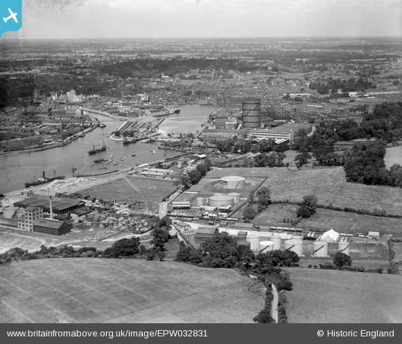
EPW032831 ENGLAND (1930). The docks, Ipswich, from the south-east, 1930
© Copyright OpenStreetMap contributors and licensed by the OpenStreetMap Foundation. 2026. Cartography is licensed as CC BY-SA.
Nearby Images (25)
Details
| Title | [EPW032831] The docks, Ipswich, from the south-east, 1930 |
| Reference | EPW032831 |
| Date | June-1930 |
| Link | |
| Place name | IPSWICH |
| Parish | |
| District | |
| Country | ENGLAND |
| Easting / Northing | 617163, 242625 |
| Longitude / Latitude | 1.1667585454071, 52.039001634829 |
| National Grid Reference | TM172426 |
Pins
Be the first to add a comment to this image!


![[EPW032831] The docks, Ipswich, from the south-east, 1930](http://britainfromabove.org.uk/sites/all/libraries/aerofilms-images/public/100x100/EPW/032/EPW032831.jpg)
![[EPW032861] The docks and town, Ipswich, from the south-east, 1930](http://britainfromabove.org.uk/sites/all/libraries/aerofilms-images/public/100x100/EPW/032/EPW032861.jpg)
![[EPW032862] The docks and town, Ipswich, from the south-east, 1930](http://britainfromabove.org.uk/sites/all/libraries/aerofilms-images/public/100x100/EPW/032/EPW032862.jpg)
![[EAW045630] Fisons Ltd Cliff Quay Works, Ipswich, 1952. This image was marked by Aerofilms Ltd for photo editing.](http://britainfromabove.org.uk/sites/all/libraries/aerofilms-images/public/100x100/EAW/045/EAW045630.jpg)
![[EPW032838] The docks and the town, Ipswich, from the south-east, 1930](http://britainfromabove.org.uk/sites/all/libraries/aerofilms-images/public/100x100/EPW/032/EPW032838.jpg)
![[EAW045631] Fisons Ltd Cliff Quay Works, Ipswich, 1952. This image was marked by Aerofilms Ltd for photo editing.](http://britainfromabove.org.uk/sites/all/libraries/aerofilms-images/public/100x100/EAW/045/EAW045631.jpg)
![[EPW032852] The Orwell Brick Works and environs, Ipswich, from the south-east, 1930](http://britainfromabove.org.uk/sites/all/libraries/aerofilms-images/public/100x100/EPW/032/EPW032852.jpg)
![[EPW032846] The docks and town, Ipswich, from the south-east, 1930](http://britainfromabove.org.uk/sites/all/libraries/aerofilms-images/public/100x100/EPW/032/EPW032846.jpg)
![[EAW045629] Fisons Ltd Cliff Quay Works, Ipswich, 1952. This image was marked by Aerofilms Ltd for photo editing.](http://britainfromabove.org.uk/sites/all/libraries/aerofilms-images/public/100x100/EAW/045/EAW045629.jpg)
![[EAW045636] Fisons Ltd Cliff Quay Works, Ipswich, 1952. This image was marked by Aerofilms Ltd for photo editing.](http://britainfromabove.org.uk/sites/all/libraries/aerofilms-images/public/100x100/EAW/045/EAW045636.jpg)
![[EAW045633] Fisons Ltd Cliff Quay Works, Ipswich, 1952. This image was marked by Aerofilms Ltd for photo editing.](http://britainfromabove.org.uk/sites/all/libraries/aerofilms-images/public/100x100/EAW/045/EAW045633.jpg)
![[EAW025119] Gabriel, Wade and English Timber Yard, Greenwich Road and environs, Ipswich, 1949. This image was marked by Aerofilms Ltd for photo editing.](http://britainfromabove.org.uk/sites/all/libraries/aerofilms-images/public/100x100/EAW/025/EAW025119.jpg)
![[EAW025120] Gabriel, Wade and English Timber Yard, the River Orwell and the town, Ipswich, from the south-east, 1949. This image was marked by Aerofilms Ltd for photo editing.](http://britainfromabove.org.uk/sites/all/libraries/aerofilms-images/public/100x100/EAW/025/EAW025120.jpg)
![[EAW025116] Gabriel, Wade and English Timber Yard and adjacent works on Cliff Quay, Ipswich, from the east, 1949. This image was marked by Aerofilms Ltd for photo editing.](http://britainfromabove.org.uk/sites/all/libraries/aerofilms-images/public/100x100/EAW/025/EAW025116.jpg)
![[EAW045628] Fisons Ltd Cliff Quay Works, Ipswich, 1952. This image was marked by Aerofilms Ltd for photo editing.](http://britainfromabove.org.uk/sites/all/libraries/aerofilms-images/public/100x100/EAW/045/EAW045628.jpg)
![[EPW032847] The docks and town, Ipswich, from the south-east, 1930](http://britainfromabove.org.uk/sites/all/libraries/aerofilms-images/public/100x100/EPW/032/EPW032847.jpg)
![[EPW032842] The Orwell Brick Works and environs, Ipswich, from the south-east, 1930](http://britainfromabove.org.uk/sites/all/libraries/aerofilms-images/public/100x100/EPW/032/EPW032842.jpg)
![[EAW045632] Fisons Ltd Cliff Quay Works, Ipswich, 1952](http://britainfromabove.org.uk/sites/all/libraries/aerofilms-images/public/100x100/EAW/045/EAW045632.jpg)
![[EAW025122] Gabriel, Wade and English Timber Yard and environs, Ipswich, from the north, 1949](http://britainfromabove.org.uk/sites/all/libraries/aerofilms-images/public/100x100/EAW/025/EAW025122.jpg)
![[EAW025118] orks on Cliff Quay and the Cliff Quay Generating Station, Ipswich, 1949](http://britainfromabove.org.uk/sites/all/libraries/aerofilms-images/public/100x100/EAW/025/EAW025118.jpg)
![[EAW045634] Fisons Ltd Cliff Quay Works, Ipswich, 1952. This image was marked by Aerofilms Ltd for photo editing.](http://britainfromabove.org.uk/sites/all/libraries/aerofilms-images/public/100x100/EAW/045/EAW045634.jpg)
![[EAW025123] Gabriel, Wade and English Timber Yard and environs, Ipswich, 1949](http://britainfromabove.org.uk/sites/all/libraries/aerofilms-images/public/100x100/EAW/025/EAW025123.jpg)
![[EPW041402] Gabriel, Wade and English Timber Yard and the Orwell Brick Works on Cliff Quay, Ipswich, 1933](http://britainfromabove.org.uk/sites/all/libraries/aerofilms-images/public/100x100/EPW/041/EPW041402.jpg)
![[EPW032844] The Orwell Brick Works, Griffin Wharf and environs, Ipswich, from the east, 1930](http://britainfromabove.org.uk/sites/all/libraries/aerofilms-images/public/100x100/EPW/032/EPW032844.jpg)
![[EAW025117] Gabriel, Wade and English Timber Yard, Greenwich Road and environs, Ipswich, from the west, 1949](http://britainfromabove.org.uk/sites/all/libraries/aerofilms-images/public/100x100/EAW/025/EAW025117.jpg)