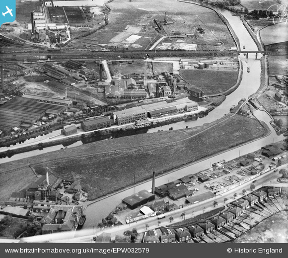
EPW032579 ENGLAND (1930). The City Saw Mills, Fall Ings and the Stennard Diamond Coal Cutter Works, Wakefield, 1930
© Copyright OpenStreetMap contributors and licensed by the OpenStreetMap Foundation. 2026. Cartography is licensed as CC BY-SA.
Nearby Images (11)
Details
| Title | [EPW032579] The City Saw Mills, Fall Ings and the Stennard Diamond Coal Cutter Works, Wakefield, 1930 |
| Reference | EPW032579 |
| Date | June-1930 |
| Link | |
| Place name | WAKEFIELD |
| Parish | |
| District | |
| Country | ENGLAND |
| Easting / Northing | 434161, 419942 |
| Longitude / Latitude | -1.4828246907268, 53.674600633257 |
| National Grid Reference | SE342199 |
Pins

sirdouglas |
Tuesday 24th of March 2015 09:42:22 PM | |

sirdouglas |
Tuesday 24th of March 2015 09:42:06 PM | |

Ray Shill |
Saturday 30th of August 2014 02:33:56 PM | |

Ray Shill |
Saturday 30th of August 2014 02:32:59 PM | |

Ray Shill |
Saturday 30th of August 2014 02:32:07 PM |


![[EPW032579] The City Saw Mills, Fall Ings and the Stennard Diamond Coal Cutter Works, Wakefield, 1930](http://britainfromabove.org.uk/sites/all/libraries/aerofilms-images/public/100x100/EPW/032/EPW032579.jpg)
![[EPW032574] The Stennard Diamond Coal Cutter Works, the Phoenix Engineering Works and Fall Ings, Wakefield, 1930](http://britainfromabove.org.uk/sites/all/libraries/aerofilms-images/public/100x100/EPW/032/EPW032574.jpg)
![[EPW032576] The Stennard Diamond Coal Cutter Works, the Phoenix Engineering Works and Fall Ings, Wakefield, 1930](http://britainfromabove.org.uk/sites/all/libraries/aerofilms-images/public/100x100/EPW/032/EPW032576.jpg)
![[EAW003096] The Brotherton and Co Ammonia Works and the surrounding industrial area, Wakefield, 1946](http://britainfromabove.org.uk/sites/all/libraries/aerofilms-images/public/100x100/EAW/003/EAW003096.jpg)
![[EAW003094] The Brotherton and Co Ammonia Works and Stennard Island, Wakefield, 1946. This image was marked by Aerofilms Ltd for photo editing.](http://britainfromabove.org.uk/sites/all/libraries/aerofilms-images/public/100x100/EAW/003/EAW003094.jpg)
![[EAW003090] The Brotherton and Co Ammonia Works, the Phoenix Engineering Works and Stennard Island, Wakefield, 1946](http://britainfromabove.org.uk/sites/all/libraries/aerofilms-images/public/100x100/EAW/003/EAW003090.jpg)
![[EAW003093] The Brotherton and Co Ammonia Works and the surrounding industrial area, Wakefield, 1946](http://britainfromabove.org.uk/sites/all/libraries/aerofilms-images/public/100x100/EAW/003/EAW003093.jpg)
![[EAW003092] The Brotherton and Co Ammonia Works, the Phoenix Engineering Works and Stennard Island, Wakefield, 1946](http://britainfromabove.org.uk/sites/all/libraries/aerofilms-images/public/100x100/EAW/003/EAW003092.jpg)
![[EAW003095] The Brotherton and Co Ammonia Works, Wakefield, 1946. This image was marked by Aerofilms Ltd for photo editing.](http://britainfromabove.org.uk/sites/all/libraries/aerofilms-images/public/100x100/EAW/003/EAW003095.jpg)
![[EAW003091] The Brotherton and Co Ammonia Works, Wakefield, from the north-east, 1946](http://britainfromabove.org.uk/sites/all/libraries/aerofilms-images/public/100x100/EAW/003/EAW003091.jpg)
![[EPW016286] Wakefield Bridge and factories beside the River Calder, Wakefield, 1926](http://britainfromabove.org.uk/sites/all/libraries/aerofilms-images/public/100x100/EPW/016/EPW016286.jpg)