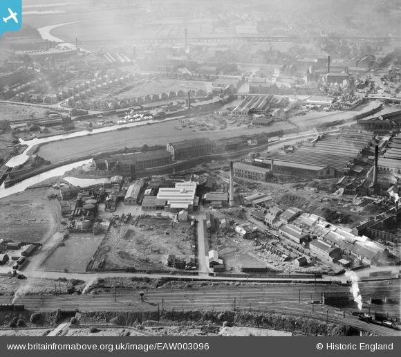
EAW003096 ENGLAND (1946). The Brotherton and Co Ammonia Works and the surrounding industrial area, Wakefield, 1946
© Copyright OpenStreetMap contributors and licensed by the OpenStreetMap Foundation. 2026. Cartography is licensed as CC BY-SA.
Nearby Images (17)
Details
| Title | [EAW003096] The Brotherton and Co Ammonia Works and the surrounding industrial area, Wakefield, 1946 |
| Reference | EAW003096 |
| Date | 11-October-1946 |
| Link | |
| Place name | WAKEFIELD |
| Parish | |
| District | |
| Country | ENGLAND |
| Easting / Northing | 434199, 419999 |
| Longitude / Latitude | -1.4822431387567, 53.67511051114 |
| National Grid Reference | SE342200 |
Pins

redmist |
Tuesday 6th of November 2018 07:10:01 PM | |

sirdouglas |
Tuesday 24th of March 2015 09:29:24 PM | |

sirdouglas |
Tuesday 24th of March 2015 09:29:04 PM |


![[EAW003096] The Brotherton and Co Ammonia Works and the surrounding industrial area, Wakefield, 1946](http://britainfromabove.org.uk/sites/all/libraries/aerofilms-images/public/100x100/EAW/003/EAW003096.jpg)
![[EAW003094] The Brotherton and Co Ammonia Works and Stennard Island, Wakefield, 1946. This image was marked by Aerofilms Ltd for photo editing.](http://britainfromabove.org.uk/sites/all/libraries/aerofilms-images/public/100x100/EAW/003/EAW003094.jpg)
![[EPW032579] The City Saw Mills, Fall Ings and the Stennard Diamond Coal Cutter Works, Wakefield, 1930](http://britainfromabove.org.uk/sites/all/libraries/aerofilms-images/public/100x100/EPW/032/EPW032579.jpg)
![[EAW003093] The Brotherton and Co Ammonia Works and the surrounding industrial area, Wakefield, 1946](http://britainfromabove.org.uk/sites/all/libraries/aerofilms-images/public/100x100/EAW/003/EAW003093.jpg)
![[EAW003090] The Brotherton and Co Ammonia Works, the Phoenix Engineering Works and Stennard Island, Wakefield, 1946](http://britainfromabove.org.uk/sites/all/libraries/aerofilms-images/public/100x100/EAW/003/EAW003090.jpg)
![[EPW032574] The Stennard Diamond Coal Cutter Works, the Phoenix Engineering Works and Fall Ings, Wakefield, 1930](http://britainfromabove.org.uk/sites/all/libraries/aerofilms-images/public/100x100/EPW/032/EPW032574.jpg)
![[EPW032576] The Stennard Diamond Coal Cutter Works, the Phoenix Engineering Works and Fall Ings, Wakefield, 1930](http://britainfromabove.org.uk/sites/all/libraries/aerofilms-images/public/100x100/EPW/032/EPW032576.jpg)
![[EAW003095] The Brotherton and Co Ammonia Works, Wakefield, 1946. This image was marked by Aerofilms Ltd for photo editing.](http://britainfromabove.org.uk/sites/all/libraries/aerofilms-images/public/100x100/EAW/003/EAW003095.jpg)
![[EAW003092] The Brotherton and Co Ammonia Works, the Phoenix Engineering Works and Stennard Island, Wakefield, 1946](http://britainfromabove.org.uk/sites/all/libraries/aerofilms-images/public/100x100/EAW/003/EAW003092.jpg)
![[EAW003091] The Brotherton and Co Ammonia Works, Wakefield, from the north-east, 1946](http://britainfromabove.org.uk/sites/all/libraries/aerofilms-images/public/100x100/EAW/003/EAW003091.jpg)
![[EAW002604] E. Green and Son Phoenix Works, Wakefield, 1946](http://britainfromabove.org.uk/sites/all/libraries/aerofilms-images/public/100x100/EAW/002/EAW002604.jpg)
![[EAW002601] E. Green and Son Phoenix Works, Wakefield, 1946](http://britainfromabove.org.uk/sites/all/libraries/aerofilms-images/public/100x100/EAW/002/EAW002601.jpg)
![[EAW002600] E. Green and Son Phoenix Works, Wakefield, 1946](http://britainfromabove.org.uk/sites/all/libraries/aerofilms-images/public/100x100/EAW/002/EAW002600.jpg)
![[EAW002605] E. Green and Son Phoenix Works, Wakefield, 1946](http://britainfromabove.org.uk/sites/all/libraries/aerofilms-images/public/100x100/EAW/002/EAW002605.jpg)
![[EAW002602] E. Green and Son Phoenix Works, Wakefield, 1946](http://britainfromabove.org.uk/sites/all/libraries/aerofilms-images/public/100x100/EAW/002/EAW002602.jpg)
![[EAW003097] The Brotherton and Co Ammonia Works and the surrounding area, Wakefield, 1946](http://britainfromabove.org.uk/sites/all/libraries/aerofilms-images/public/100x100/EAW/003/EAW003097.jpg)
![[EAW002603] E. Green and Son Phoenix Works and environs, Wakefield, 1946](http://britainfromabove.org.uk/sites/all/libraries/aerofilms-images/public/100x100/EAW/002/EAW002603.jpg)