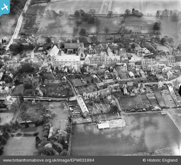
EPW031884 ENGLAND (1930). Uppingham School and environs, Uppingham, 1930
© Copyright OpenStreetMap contributors and licensed by the OpenStreetMap Foundation. 2026. Cartography is licensed as CC BY-SA.
Nearby Images (14)
Details
| Title | [EPW031884] Uppingham School and environs, Uppingham, 1930 |
| Reference | EPW031884 |
| Date | May-1930 |
| Link | |
| Place name | UPPINGHAM |
| Parish | UPPINGHAM |
| District | |
| Country | ENGLAND |
| Easting / Northing | 486478, 299729 |
| Longitude / Latitude | -0.72337006000454, 52.588120146859 |
| National Grid Reference | SP865997 |
Pins
Be the first to add a comment to this image!


![[EPW031884] Uppingham School and environs, Uppingham, 1930](http://britainfromabove.org.uk/sites/all/libraries/aerofilms-images/public/100x100/EPW/031/EPW031884.jpg)
![[EPW047305] Uppingham School and environs, Uppingham, 1935](http://britainfromabove.org.uk/sites/all/libraries/aerofilms-images/public/100x100/EPW/047/EPW047305.jpg)
![[EPW047304] Uppingham School and environs, Uppingham, 1935](http://britainfromabove.org.uk/sites/all/libraries/aerofilms-images/public/100x100/EPW/047/EPW047304.jpg)
![[EPW031887] Uppingham School and the town, Uppingham, 1930](http://britainfromabove.org.uk/sites/all/libraries/aerofilms-images/public/100x100/EPW/031/EPW031887.jpg)
![[EPW047307] Uppingham School and the High Street, Uppingham, 1935](http://britainfromabove.org.uk/sites/all/libraries/aerofilms-images/public/100x100/EPW/047/EPW047307.jpg)
![[EPW047306] Uppingham School and the High Street, Uppingham, 1935](http://britainfromabove.org.uk/sites/all/libraries/aerofilms-images/public/100x100/EPW/047/EPW047306.jpg)
![[EPW047303] Uppingham School and the High Street, Uppingham, 1935](http://britainfromabove.org.uk/sites/all/libraries/aerofilms-images/public/100x100/EPW/047/EPW047303.jpg)
![[EPW058208] Uppingham School and the town, Uppingham, 1938](http://britainfromabove.org.uk/sites/all/libraries/aerofilms-images/public/100x100/EPW/058/EPW058208.jpg)
![[EPW047308] Uppingham School, Uppingham, 1935](http://britainfromabove.org.uk/sites/all/libraries/aerofilms-images/public/100x100/EPW/047/EPW047308.jpg)
![[EPW031886] Uppingham School and the town, Uppingham, 1930](http://britainfromabove.org.uk/sites/all/libraries/aerofilms-images/public/100x100/EPW/031/EPW031886.jpg)
![[EPW031883] Uppingham School, Uppingham, 1930](http://britainfromabove.org.uk/sites/all/libraries/aerofilms-images/public/100x100/EPW/031/EPW031883.jpg)
![[EPW031861] Uppingham School and environs, Uppingham, 1930](http://britainfromabove.org.uk/sites/all/libraries/aerofilms-images/public/100x100/EPW/031/EPW031861.jpg)
![[EPW031888] St Peter and St Paul's Church, the Market Place and environs, Uppingham, 1930](http://britainfromabove.org.uk/sites/all/libraries/aerofilms-images/public/100x100/EPW/031/EPW031888.jpg)
![[EPW031857] St Peter and St Paul's Church and the town centre, Uppingham, 1930](http://britainfromabove.org.uk/sites/all/libraries/aerofilms-images/public/100x100/EPW/031/EPW031857.jpg)