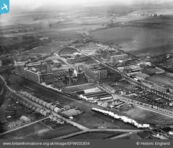
EPW031834 ENGLAND (1930). Gramophone Company (HMV) factory buildings and environs, Hayes, from the south-east, 1930
© Copyright OpenStreetMap contributors and licensed by the OpenStreetMap Foundation. 2026. Cartography is licensed as CC BY-SA.
Nearby Images (22)
Details
| Title | [EPW031834] Gramophone Company (HMV) factory buildings and environs, Hayes, from the south-east, 1930 |
| Reference | EPW031834 |
| Date | 7-May-1930 |
| Link | |
| Place name | HAYES |
| Parish | |
| District | |
| Country | ENGLAND |
| Easting / Northing | 509431, 179454 |
| Longitude / Latitude | -0.42317677609475, 51.502930172316 |
| National Grid Reference | TQ094795 |
Pins
Be the first to add a comment to this image!


![[EPW031834] Gramophone Company (HMV) factory buildings and environs, Hayes, from the south-east, 1930](http://britainfromabove.org.uk/sites/all/libraries/aerofilms-images/public/100x100/EPW/031/EPW031834.jpg)
![[EPW031821] Gramophone Company (HMV) factory buildings and environs, Hayes, 1930](http://britainfromabove.org.uk/sites/all/libraries/aerofilms-images/public/100x100/EPW/031/EPW031821.jpg)
![[EPW031820] Gramophone Company (HMV) factory buildings and environs, Hayes, 1930](http://britainfromabove.org.uk/sites/all/libraries/aerofilms-images/public/100x100/EPW/031/EPW031820.jpg)
![[EPW031819] Gramophone Company (HMV) factory buildings and environs, Hayes, 1930](http://britainfromabove.org.uk/sites/all/libraries/aerofilms-images/public/100x100/EPW/031/EPW031819.jpg)
![[EPW008026] His Master's Voice Gramophone Works, Hayes, 1922](http://britainfromabove.org.uk/sites/all/libraries/aerofilms-images/public/100x100/EPW/008/EPW008026.jpg)
![[EPW037590] The HMV Gramophone Factories, Hayes, 1932](http://britainfromabove.org.uk/sites/all/libraries/aerofilms-images/public/100x100/EPW/037/EPW037590.jpg)
![[EPW008027] His Master's Voice Gramophone Works, Hayes, 1922](http://britainfromabove.org.uk/sites/all/libraries/aerofilms-images/public/100x100/EPW/008/EPW008027.jpg)
![[EPW031817] Blyth Road, Gramophone Company (HMV) factory buildings and environs, Hayes, 1930](http://britainfromabove.org.uk/sites/all/libraries/aerofilms-images/public/100x100/EPW/031/EPW031817.jpg)
![[EPW005151] His Master's Voice Gramophone Factories, Hayes, 1920](http://britainfromabove.org.uk/sites/all/libraries/aerofilms-images/public/100x100/EPW/005/EPW005151.jpg)
![[EPW031839] Gramophone Company (HMV) factory buildings and environs, Hayes, 1930](http://britainfromabove.org.uk/sites/all/libraries/aerofilms-images/public/100x100/EPW/031/EPW031839.jpg)
![[EPW015337] Gramophone Factories, Hayes, 1926](http://britainfromabove.org.uk/sites/all/libraries/aerofilms-images/public/100x100/EPW/015/EPW015337.jpg)
![[EPW031822] Gramophone Company (HMV) factory buildings and environs, Hayes, from the south, 1930](http://britainfromabove.org.uk/sites/all/libraries/aerofilms-images/public/100x100/EPW/031/EPW031822.jpg)
![[EPW031818] Hayes and Harlington railway station, Gramophone Company (HMV) factory buildings and environs, Hayes, 1930](http://britainfromabove.org.uk/sites/all/libraries/aerofilms-images/public/100x100/EPW/031/EPW031818.jpg)
![[EPW015336] Gramophone Factories, Hayes, 1926](http://britainfromabove.org.uk/sites/all/libraries/aerofilms-images/public/100x100/EPW/015/EPW015336.jpg)
![[EPW031823] Gramophone Company (HMV) factory buildings and environs, Hayes, 1930](http://britainfromabove.org.uk/sites/all/libraries/aerofilms-images/public/100x100/EPW/031/EPW031823.jpg)
![[EPW008028] His Master's Voice Gramophone Works, Hayes, 1922](http://britainfromabove.org.uk/sites/all/libraries/aerofilms-images/public/100x100/EPW/008/EPW008028.jpg)
![[EPW005150] His Master's Voice Gramophone Factories, Hayes, 1920](http://britainfromabove.org.uk/sites/all/libraries/aerofilms-images/public/100x100/EPW/005/EPW005150.jpg)
![[EPW037573] The HMV Gramophone Factories, Hayes, from the south, 1932](http://britainfromabove.org.uk/sites/all/libraries/aerofilms-images/public/100x100/EPW/037/EPW037573.jpg)
![[EPW031825] Gramophone Company (HMV) factory buildings and environs, Hayes, 1930](http://britainfromabove.org.uk/sites/all/libraries/aerofilms-images/public/100x100/EPW/031/EPW031825.jpg)
![[EPW037589] The HMV Gramophone Factories, Hayes, from the south-east, 1932](http://britainfromabove.org.uk/sites/all/libraries/aerofilms-images/public/100x100/EPW/037/EPW037589.jpg)
![[EPW031824] Gramophone Company (HMV) factory buildings and environs, Hayes, 1930](http://britainfromabove.org.uk/sites/all/libraries/aerofilms-images/public/100x100/EPW/031/EPW031824.jpg)
![[EPW031837] Gramophone Company (HMV) factory buildings and environs, Hayes, from the south-east, 1930](http://britainfromabove.org.uk/sites/all/libraries/aerofilms-images/public/100x100/EPW/031/EPW031837.jpg)