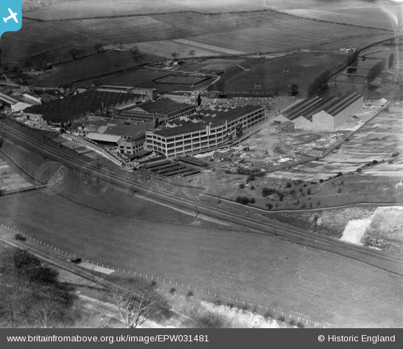
EPW031481 ENGLAND (1930). The Vauxhall Motor Car Works, Luton, 1930
© Copyright OpenStreetMap contributors and licensed by the OpenStreetMap Foundation. 2026. Cartography is licensed as CC BY-SA.
Nearby Images (42)
Details
| Title | [EPW031481] The Vauxhall Motor Car Works, Luton, 1930 |
| Reference | EPW031481 |
| Date | February-1930 |
| Link | |
| Place name | LUTON |
| Parish | |
| District | |
| Country | ENGLAND |
| Easting / Northing | 510745, 220471 |
| Longitude / Latitude | -0.39123195201609, 51.871363711378 |
| National Grid Reference | TL107205 |
Pins
Be the first to add a comment to this image!


![[EPW031481] The Vauxhall Motor Car Works, Luton, 1930](http://britainfromabove.org.uk/sites/all/libraries/aerofilms-images/public/100x100/EPW/031/EPW031481.jpg)
![[EPW040903] The Vauxhall Motor Car Works, Luton, 1933](http://britainfromabove.org.uk/sites/all/libraries/aerofilms-images/public/100x100/EPW/040/EPW040903.jpg)
![[EPW031484] The Vauxhall Motor Car Works and Allotments, Luton, 1930](http://britainfromabove.org.uk/sites/all/libraries/aerofilms-images/public/100x100/EPW/031/EPW031484.jpg)
![[EPW031478] The Vauxhall Motor Car Works, Luton, 1930](http://britainfromabove.org.uk/sites/all/libraries/aerofilms-images/public/100x100/EPW/031/EPW031478.jpg)
![[EPW031487] The Vauxhall Motor Car Works, Luton, 1930](http://britainfromabove.org.uk/sites/all/libraries/aerofilms-images/public/100x100/EPW/031/EPW031487.jpg)
![[EPW040908] The Vauxhall Motor Car Works and surrounding countryside, Luton, from the south, 1933](http://britainfromabove.org.uk/sites/all/libraries/aerofilms-images/public/100x100/EPW/040/EPW040908.jpg)
![[EAW050186B] Vauxhall Motors Ltd Works and environs, Luton, from the south-east, 1953. This image was marked by Aerofilms Ltd for photo editing.](http://britainfromabove.org.uk/sites/all/libraries/aerofilms-images/public/100x100/EAW/050/EAW050186B.jpg)
![[EPW031486] The Vauxhall Motor Car Works, Luton, 1930](http://britainfromabove.org.uk/sites/all/libraries/aerofilms-images/public/100x100/EPW/031/EPW031486.jpg)
![[EPW019222] Vauxhall Motor Works, Luton, 1927](http://britainfromabove.org.uk/sites/all/libraries/aerofilms-images/public/100x100/EPW/019/EPW019222.jpg)
![[EPW031475] The Vauxhall Motor Car Works, Luton, 1930](http://britainfromabove.org.uk/sites/all/libraries/aerofilms-images/public/100x100/EPW/031/EPW031475.jpg)
![[EPW031473] The Vauxhall Motor Car Works, Luton, 1930](http://britainfromabove.org.uk/sites/all/libraries/aerofilms-images/public/100x100/EPW/031/EPW031473.jpg)
![[EPW031477] The Vauxhall Motor Car Works and Allotments, Luton, 1930](http://britainfromabove.org.uk/sites/all/libraries/aerofilms-images/public/100x100/EPW/031/EPW031477.jpg)
![[EPW031479] The Vauxhall Motor Car Works, Luton, 1930](http://britainfromabove.org.uk/sites/all/libraries/aerofilms-images/public/100x100/EPW/031/EPW031479.jpg)
![[EPW048408] Vauxhall Motor Works, Luton, 1935](http://britainfromabove.org.uk/sites/all/libraries/aerofilms-images/public/100x100/EPW/048/EPW048408.jpg)
![[EPW022399] The Vauxhall Motors Ltd Engineering Works, Luton, 1928](http://britainfromabove.org.uk/sites/all/libraries/aerofilms-images/public/100x100/EPW/022/EPW022399.jpg)
![[EAW050179] Vauxhall Motors Ltd Works and Hart Hill, Luton, from the south-east, 1953. This image was marked by Aerofilms Ltd for photo editing.](http://britainfromabove.org.uk/sites/all/libraries/aerofilms-images/public/100x100/EAW/050/EAW050179.jpg)
![[EPW031476] The Vauxhall Motor Car Works and Kimpton Road, Luton, 1930](http://britainfromabove.org.uk/sites/all/libraries/aerofilms-images/public/100x100/EPW/031/EPW031476.jpg)
![[EAW050186] Vauxhall Motors Ltd Works and environs, Luton, from the south-east, 1953. This image was marked by Aerofilms Ltd for photo editing.](http://britainfromabove.org.uk/sites/all/libraries/aerofilms-images/public/100x100/EAW/050/EAW050186.jpg)
![[EPW031474] The Vauxhall Motor Car Works, Luton, 1930](http://britainfromabove.org.uk/sites/all/libraries/aerofilms-images/public/100x100/EPW/031/EPW031474.jpg)
![[EPW040911] The Vauxhall Motor Car Works, Luton, 1933](http://britainfromabove.org.uk/sites/all/libraries/aerofilms-images/public/100x100/EPW/040/EPW040911.jpg)
![[EPW040904] The Vauxhall Motor Car Works, Luton, 1933](http://britainfromabove.org.uk/sites/all/libraries/aerofilms-images/public/100x100/EPW/040/EPW040904.jpg)
![[EPR000042] Vauxhall Motors Ltd Engineering Works, Luton, from the south, 1934](http://britainfromabove.org.uk/sites/all/libraries/aerofilms-images/public/100x100/EPR/000/EPR000042.jpg)
![[EPW019223] Vauxhall Motor Works, Luton, 1927](http://britainfromabove.org.uk/sites/all/libraries/aerofilms-images/public/100x100/EPW/019/EPW019223.jpg)
![[EPR000041] Vauxhall Motors Ltd Engineering Works beyond the northern end of Luton Hoo Park, Luton, 1934. This image was marked by Aero Pictorial Ltd for photo editing.](http://britainfromabove.org.uk/sites/all/libraries/aerofilms-images/public/100x100/EPR/000/EPR000041.jpg)
![[EPW022403] The Vauxhall Motors Ltd Engineering Works, Luton, 1928](http://britainfromabove.org.uk/sites/all/libraries/aerofilms-images/public/100x100/EPW/022/EPW022403.jpg)
![[EPW046837] The Vauxhall Motor Car Works and the town, Luton, 1935](http://britainfromabove.org.uk/sites/all/libraries/aerofilms-images/public/100x100/EPW/046/EPW046837.jpg)
![[EPW046592] The Vauxhall Motor Works, Luton, 1935](http://britainfromabove.org.uk/sites/all/libraries/aerofilms-images/public/100x100/EPW/046/EPW046592.jpg)
![[EPW040906] The Vauxhall Motor Car Works and surrounding countryside, Luton, 1933](http://britainfromabove.org.uk/sites/all/libraries/aerofilms-images/public/100x100/EPW/040/EPW040906.jpg)
![[EPW046838] The Vauxhall Motor Car Works, Luton, 1935](http://britainfromabove.org.uk/sites/all/libraries/aerofilms-images/public/100x100/EPW/046/EPW046838.jpg)
![[EPR000043] Vauxhall Motors Ltd Engineering Works, Luton, from the south-west, 1934](http://britainfromabove.org.uk/sites/all/libraries/aerofilms-images/public/100x100/EPR/000/EPR000043.jpg)
![[EPR000044] Vauxhall Motors Ltd Engineering Works, Luton, from the south, 1934](http://britainfromabove.org.uk/sites/all/libraries/aerofilms-images/public/100x100/EPR/000/EPR000044.jpg)
![[EPR000045] Vauxhall Motors Ltd Engineering Works beyond the northern end of Luton Hoo Park, Luton, 1934](http://britainfromabove.org.uk/sites/all/libraries/aerofilms-images/public/100x100/EPR/000/EPR000045.jpg)
![[EPW048406] Vauxhall Motor Works, Luton. 1935](http://britainfromabove.org.uk/sites/all/libraries/aerofilms-images/public/100x100/EPW/048/EPW048406.jpg)
![[EPW048407] Vauxhall Motor Works, the Luton Corporation Sewage Farm and environs, Luton, 1935](http://britainfromabove.org.uk/sites/all/libraries/aerofilms-images/public/100x100/EPW/048/EPW048407.jpg)
![[EPW046589] The Vauxhall Motor Works, Luton, 1935](http://britainfromabove.org.uk/sites/all/libraries/aerofilms-images/public/100x100/EPW/046/EPW046589.jpg)
![[EPW048414] Vauxhall Motor Works and environs, Luton, from the south, 1935](http://britainfromabove.org.uk/sites/all/libraries/aerofilms-images/public/100x100/EPW/048/EPW048414.jpg)
![[EPW048415] Vauxhall Motor Works and environs, Luton, from the south-east, 1935](http://britainfromabove.org.uk/sites/all/libraries/aerofilms-images/public/100x100/EPW/048/EPW048415.jpg)
![[EPW046835] The Vauxhall Motor Car Works, Luton, 1935](http://britainfromabove.org.uk/sites/all/libraries/aerofilms-images/public/100x100/EPW/046/EPW046835.jpg)
![[EPW046836] The Vauxhall Motor Car Works and the town, Luton, 1935](http://britainfromabove.org.uk/sites/all/libraries/aerofilms-images/public/100x100/EPW/046/EPW046836.jpg)
![[EAW000079] The Vauxhall Motor Works painted in camouflage, Luton, 1946](http://britainfromabove.org.uk/sites/all/libraries/aerofilms-images/public/100x100/EAW/000/EAW000079.jpg)
![[EPW046586] The Vauxhall Motor Works, Luton, 1935](http://britainfromabove.org.uk/sites/all/libraries/aerofilms-images/public/100x100/EPW/046/EPW046586.jpg)
![[EPW031482] The Vauxhall Motor Car Works, Luton Hoo Park, from the south, 1930](http://britainfromabove.org.uk/sites/all/libraries/aerofilms-images/public/100x100/EPW/031/EPW031482.jpg)