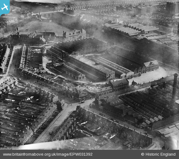
EPW031392 ENGLAND (1930). The East Motor Works, Bordesley Green, 1930
© Copyright OpenStreetMap contributors and licensed by the OpenStreetMap Foundation. 2026. Cartography is licensed as CC BY-SA.
Nearby Images (48)
Details
| Title | [EPW031392] The East Motor Works, Bordesley Green, 1930 |
| Reference | EPW031392 |
| Date | February-1930 |
| Link | |
| Place name | BORDESLEY GREEN |
| Parish | |
| District | |
| Country | ENGLAND |
| Easting / Northing | 409908, 287387 |
| Longitude / Latitude | -1.8540822011708, 52.483944899126 |
| National Grid Reference | SP099874 |
Pins
User Comment Contributions

Brasspot |
Tuesday 26th of June 2012 07:48:11 PM |


![[EPW031392] The East Motor Works, Bordesley Green, 1930](http://britainfromabove.org.uk/sites/all/libraries/aerofilms-images/public/100x100/EPW/031/EPW031392.jpg)
![[EPW045024] The Morris Motor Works, the Adderley Park Brick Works and the surrounding residential area, Saltley, 1934](http://britainfromabove.org.uk/sites/all/libraries/aerofilms-images/public/100x100/EPW/045/EPW045024.jpg)
![[EPW031386] The East Motor Works, Arden Road and surroundings, Bordesley Green, 1930](http://britainfromabove.org.uk/sites/all/libraries/aerofilms-images/public/100x100/EPW/031/EPW031386.jpg)
![[EPW044599] The Durex Abrasives Works, the Morris Motor Car Works and Adderley Park, Saltley, 1934](http://britainfromabove.org.uk/sites/all/libraries/aerofilms-images/public/100x100/EPW/044/EPW044599.jpg)
![[EPW036126] The Wolseley Tool and Motor Car Works, Birmingham, 1931](http://britainfromabove.org.uk/sites/all/libraries/aerofilms-images/public/100x100/EPW/036/EPW036126.jpg)
![[EPW037048] The Wolseley Motor Works and environs, Saltley, 1931](http://britainfromabove.org.uk/sites/all/libraries/aerofilms-images/public/100x100/EPW/037/EPW037048.jpg)
![[EPW037052] The Adderley Varnish Works, Wolseley Motor Works and environs, Saltley, 1931](http://britainfromabove.org.uk/sites/all/libraries/aerofilms-images/public/100x100/EPW/037/EPW037052.jpg)
![[EPW036918] The Wolseley Motor Works and environs, Birmingham, 1931](http://britainfromabove.org.uk/sites/all/libraries/aerofilms-images/public/100x100/EPW/036/EPW036918.jpg)
![[EPW037042] Cherrywood Road, The Wolseley Motor Works and environs, Saltley, 1931](http://britainfromabove.org.uk/sites/all/libraries/aerofilms-images/public/100x100/EPW/037/EPW037042.jpg)
![[EPW031389] The East Motor Works, Bordesley Green Road and surroundings, Bordesley Green, 1930](http://britainfromabove.org.uk/sites/all/libraries/aerofilms-images/public/100x100/EPW/031/EPW031389.jpg)
![[EPW036920] The Wolseley Motor Works, Adderley Park and environs, Birmingham, 1931](http://britainfromabove.org.uk/sites/all/libraries/aerofilms-images/public/100x100/EPW/036/EPW036920.jpg)
![[EPW031296] The Adderley Park Motor Works and the Adderley Park Brick Works, Birmingham, 1930](http://britainfromabove.org.uk/sites/all/libraries/aerofilms-images/public/100x100/EPW/031/EPW031296.jpg)
![[EPW036917] The Wolseley Motor Works and environs, Birmingham, 1931](http://britainfromabove.org.uk/sites/all/libraries/aerofilms-images/public/100x100/EPW/036/EPW036917.jpg)
![[EPW036922] The Wolseley Motor Works and environs, Birmingham, 1931](http://britainfromabove.org.uk/sites/all/libraries/aerofilms-images/public/100x100/EPW/036/EPW036922.jpg)
![[EPW044606] The Morris Motor Car Works, the Durex Abrasives Works and Adderley Park, Saltley, 1934](http://britainfromabove.org.uk/sites/all/libraries/aerofilms-images/public/100x100/EPW/044/EPW044606.jpg)
![[EPW031298] The Adderley Park Motor Works and Cherrywood Road, Birmingham, 1930](http://britainfromabove.org.uk/sites/all/libraries/aerofilms-images/public/100x100/EPW/031/EPW031298.jpg)
![[EPW044603] The Morris Motor Car Works, Adderley Park and St Saviour's Church, Saltley, 1934](http://britainfromabove.org.uk/sites/all/libraries/aerofilms-images/public/100x100/EPW/044/EPW044603.jpg)
![[EPW031297] The Adderley Park Motor Works and Cherrywood Road, Birmingham, 1930](http://britainfromabove.org.uk/sites/all/libraries/aerofilms-images/public/100x100/EPW/031/EPW031297.jpg)
![[EPW044605] The Morris Motor Car Works, the Durex Abrasives Works and Adderley Park, Saltley, 1934](http://britainfromabove.org.uk/sites/all/libraries/aerofilms-images/public/100x100/EPW/044/EPW044605.jpg)
![[EPW036136] The Wolseley Tool and Motor Car Works, Birmingham, 1931](http://britainfromabove.org.uk/sites/all/libraries/aerofilms-images/public/100x100/EPW/036/EPW036136.jpg)
![[EPW045022] The Morris Motor Works, Adderley Park and the surrounding residential area, Saltley, 1934](http://britainfromabove.org.uk/sites/all/libraries/aerofilms-images/public/100x100/EPW/045/EPW045022.jpg)
![[EPW036127] The Wolseley Tool and Motor Car Works, Birmingham, 1931](http://britainfromabove.org.uk/sites/all/libraries/aerofilms-images/public/100x100/EPW/036/EPW036127.jpg)
![[EPW044604] The Morris Motor Car Works and the Durex Abrasives Works, Saltley, 1934](http://britainfromabove.org.uk/sites/all/libraries/aerofilms-images/public/100x100/EPW/044/EPW044604.jpg)
![[EPW045020] The Morris Motor Works, Adderley Park and the surrounding residential area, Saltley, 1934](http://britainfromabove.org.uk/sites/all/libraries/aerofilms-images/public/100x100/EPW/045/EPW045020.jpg)
![[EPW045019] The Morris Motor Works, Adderley Park and the surrounding residential area, Saltley, 1934](http://britainfromabove.org.uk/sites/all/libraries/aerofilms-images/public/100x100/EPW/045/EPW045019.jpg)
![[EPW036132] The Wolseley Tool and Motor Car Works, Birmingham, 1931](http://britainfromabove.org.uk/sites/all/libraries/aerofilms-images/public/100x100/EPW/036/EPW036132.jpg)
![[EPW036923] The Wolseley Motor Works and environs, Birmingham, 1931](http://britainfromabove.org.uk/sites/all/libraries/aerofilms-images/public/100x100/EPW/036/EPW036923.jpg)
![[EPW045023] The Morris Motor Works, Adderley Park and the surrounding residential area, Saltley, 1934](http://britainfromabove.org.uk/sites/all/libraries/aerofilms-images/public/100x100/EPW/045/EPW045023.jpg)
![[EPW045501] The Durex Abrasives Works and environs, Saltley, 1934. This image has been produced from a damaged negative.](http://britainfromabove.org.uk/sites/all/libraries/aerofilms-images/public/100x100/EPW/045/EPW045501.jpg)
![[EPW036137] The Wolseley Tool and Motor Car Works and Adderley Park Brick Works, Birmingham, 1931](http://britainfromabove.org.uk/sites/all/libraries/aerofilms-images/public/100x100/EPW/036/EPW036137.jpg)
![[EPW036133] The Wolseley Tool and Motor Car Works, Birmingham, 1931](http://britainfromabove.org.uk/sites/all/libraries/aerofilms-images/public/100x100/EPW/036/EPW036133.jpg)
![[EPW036924] The Wolseley Motor Works and environs, Birmingham, 1931](http://britainfromabove.org.uk/sites/all/libraries/aerofilms-images/public/100x100/EPW/036/EPW036924.jpg)
![[EPW005705] Wolseley Motor Works and Adderley Park Brick Works, Adderley Park Station, 1921](http://britainfromabove.org.uk/sites/all/libraries/aerofilms-images/public/100x100/EPW/005/EPW005705.jpg)
![[EPW037049] The Wolseley Motor Works and Adderley Park Brick Works, Saltley, 1931](http://britainfromabove.org.uk/sites/all/libraries/aerofilms-images/public/100x100/EPW/037/EPW037049.jpg)
![[EPW036130] The Wolseley Tool and Motor Car Works, Birmingham, 1931](http://britainfromabove.org.uk/sites/all/libraries/aerofilms-images/public/100x100/EPW/036/EPW036130.jpg)
![[EPW044600] The Durex Abrasives Works, the Morris Motor Car Works and Adderley Park, Saltley, 1934](http://britainfromabove.org.uk/sites/all/libraries/aerofilms-images/public/100x100/EPW/044/EPW044600.jpg)
![[EPW031294] The Adderley Park Motor Works and the Adderley Park Brick Works, Birmingham, 1930](http://britainfromabove.org.uk/sites/all/libraries/aerofilms-images/public/100x100/EPW/031/EPW031294.jpg)
![[EPW031295] The Adderley Park Motor Works and the Adderley Park Brick Works, Birmingham, 1930](http://britainfromabove.org.uk/sites/all/libraries/aerofilms-images/public/100x100/EPW/031/EPW031295.jpg)
![[EPW037050] The Wolseley Motor Works and Adderley Park Brick Works, Saltley, 1931](http://britainfromabove.org.uk/sites/all/libraries/aerofilms-images/public/100x100/EPW/037/EPW037050.jpg)
![[EPW045021] The Morris Motor Works, Adderley Park and the surrounding residential area, Saltley, 1934](http://britainfromabove.org.uk/sites/all/libraries/aerofilms-images/public/100x100/EPW/045/EPW045021.jpg)
![[EPW037047] The Wolseley Motor Works and Adderley Park Brick Works, Saltley, 1931](http://britainfromabove.org.uk/sites/all/libraries/aerofilms-images/public/100x100/EPW/037/EPW037047.jpg)
![[EPW036131] The Wolseley Tool and Motor Car Works, Birmingham, 1931](http://britainfromabove.org.uk/sites/all/libraries/aerofilms-images/public/100x100/EPW/036/EPW036131.jpg)
![[EPW037051] The Wolseley Motor Works and Adderley Park Brick Works, Saltley, 1931](http://britainfromabove.org.uk/sites/all/libraries/aerofilms-images/public/100x100/EPW/037/EPW037051.jpg)
![[EPW036925] The Wolseley Motor Works and environs, Birmingham, 1931](http://britainfromabove.org.uk/sites/all/libraries/aerofilms-images/public/100x100/EPW/036/EPW036925.jpg)
![[EPW036129] The Wolseley Tool and Motor Car Works, Birmingham, 1931](http://britainfromabove.org.uk/sites/all/libraries/aerofilms-images/public/100x100/EPW/036/EPW036129.jpg)
![[EPW036921] The Wolseley Motor Works, Adderley Park Brick Works and environs, Birmingham, 1931](http://britainfromabove.org.uk/sites/all/libraries/aerofilms-images/public/100x100/EPW/036/EPW036921.jpg)
![[EPW037041] The Wolseley Motor Works and Adderley Park Brick Works, Saltley, 1931](http://britainfromabove.org.uk/sites/all/libraries/aerofilms-images/public/100x100/EPW/037/EPW037041.jpg)
![[EPW036134] The Wolseley Tool and Motor Car Works, Birmingham, 1931](http://britainfromabove.org.uk/sites/all/libraries/aerofilms-images/public/100x100/EPW/036/EPW036134.jpg)
